
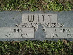
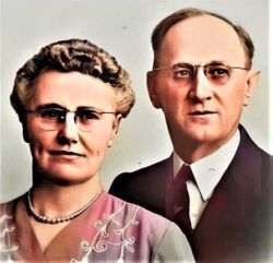
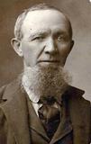
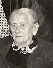
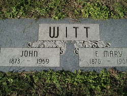
Fredricka Mary Brunken Witt
| Birth | : | 16 Jul 1876 Passaic, Passaic County, New Jersey, USA |
| Death | : | 14 Dec 1968 Genoa, Nance County, Nebraska, USA |
| Burial | : | Desert Lawn Memorial Park, Kennewick, Benton County, USA |
| Coordinate | : | 46.1983643, -119.1785507 |
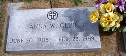
| Description | : | She often went by the name "Mary" rather than Fredricka and also called "Ricki or Rickie". Educated in rural Platte county Nebraska schools. Married John Witt on October 20, 1898. They resided in Scribner, Leigh, Potter and Columbus, Nebraska. Survivors included six children, Mrs. Clara Muir of Fremont, George Witt of San Fernando, Calif., Mrs. Jacob (Anna) Glur of Columbus, Harry Witt of Long Beach, Calif., Leroy of Bonners Ferry, Idaho and Clifford of Planda, Calif., 25 grandchildren and 39 great grandchildren. ~~~ Children not yet linked (1-8-2018) are: Harry J. Witt (born July 8,... Read More |
frequently asked questions (FAQ):
-
Where is Fredricka Mary Brunken Witt's memorial?
Fredricka Mary Brunken Witt's memorial is located at: Desert Lawn Memorial Park, Kennewick, Benton County, USA.
-
When did Fredricka Mary Brunken Witt death?
Fredricka Mary Brunken Witt death on 14 Dec 1968 in Genoa, Nance County, Nebraska, USA
-
Where are the coordinates of the Fredricka Mary Brunken Witt's memorial?
Latitude: 46.1983643
Longitude: -119.1785507
Family Members:
Parent
Spouse
Siblings

Children
Flowers:


Nearby Cemetories:
1. Desert Lawn Memorial Park
Kennewick, Benton County, USA
Coordinate: 46.1983643, -119.1785507
2. Saint Paul's Episcopal Church Columbarium
Kennewick, Benton County, USA
Coordinate: 46.1978264, -119.1408081
3. Riverview Heights Cemetery
Kennewick, Benton County, USA
Coordinate: 46.1977768, -119.1400986
4. Saint Joseph Catholic Church Columbarium
Kennewick, Benton County, USA
Coordinate: 46.2041750, -119.1281330
5. Columbia Memorial Gardens
Pasco, Franklin County, USA
Coordinate: 46.2294006, -119.1216965
6. City View Cemetery
Pasco, Franklin County, USA
Coordinate: 46.2496986, -119.0852966
7. Resthaven Cemetery
Richland, Benton County, USA
Coordinate: 46.2861023, -119.2804413
8. All Saints Episcopal Church Memorial Garden
Richland, Benton County, USA
Coordinate: 46.2875000, -119.2824000
9. Sunset Memorial Gardens
Richland, Benton County, USA
Coordinate: 46.2825127, -119.3098602
10. Burbank Cemetery
Walla Walla County, USA
Coordinate: 46.1975365, -118.9809036
11. Country Christian Center Cemetery
Pasco, Franklin County, USA
Coordinate: 46.3873600, -119.1831800
12. Horse Heaven Hills Cemetery
Benton County, USA
Coordinate: 46.1551018, -119.4826736
13. Old German Baptist Brethren Church Cemetery
Pasco, Franklin County, USA
Coordinate: 46.4156800, -119.1566600
14. Wallula Cemetery
Wallula, Walla Walla County, USA
Coordinate: 46.0844400, -118.8997200
15. Evergreen Cemetery
Benton City, Benton County, USA
Coordinate: 46.2867012, -119.4938965
16. Eltopia Cemetery
Eltopia, Franklin County, USA
Coordinate: 46.4608002, -119.0222015
17. Pioneer Memorial Cemetery
Umatilla, Umatilla County, USA
Coordinate: 45.9164009, -119.3486023
18. Sunset Hills Cemetery
Umatilla, Umatilla County, USA
Coordinate: 45.9077988, -119.3507996
19. Holdman Cemetery
Holdman, Umatilla County, USA
Coordinate: 45.8744011, -118.9443970
20. Desert Lawn Memorial Cemetery
Irrigon, Morrow County, USA
Coordinate: 45.8972015, -119.4721985
21. Paterson Memorial Cemetery
Paterson, Benton County, USA
Coordinate: 45.9437943, -119.5705566
22. Stanfield Hutterite Cemetery
Stanfield, Umatilla County, USA
Coordinate: 45.8271307, -119.0798728
23. Country View Cemetery
Basin City, Franklin County, USA
Coordinate: 46.5768210, -119.1484080
24. Hermiston Cemetery
Hermiston, Umatilla County, USA
Coordinate: 45.8236008, -119.2806015