

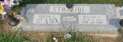
Frieda Elaine Buss Straube
| Birth | : | 15 Apr 1932 Adams, Gage County, Nebraska, USA |
| Death | : | 28 Dec 2012 Syracuse, Otoe County, Nebraska, USA |
| Burial | : | Hope Lutheran Cemetery, Burr, Otoe County, USA |
| Coordinate | : | 40.5525017, -96.2938995 |
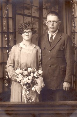
| Description | : | Frieda married Ralph N. Straube on March 8, 1953 at the American Lutheran Church in Adams, Nebraska. They are the parents of Lyle, Joyce, Doris, Lee & Jim. |
frequently asked questions (FAQ):
-
Where is Frieda Elaine Buss Straube's memorial?
Frieda Elaine Buss Straube's memorial is located at: Hope Lutheran Cemetery, Burr, Otoe County, USA.
-
When did Frieda Elaine Buss Straube death?
Frieda Elaine Buss Straube death on 28 Dec 2012 in Syracuse, Otoe County, Nebraska, USA
-
Where are the coordinates of the Frieda Elaine Buss Straube's memorial?
Latitude: 40.5525017
Longitude: -96.2938995
Family Members:
Parent
Spouse
Siblings

Flowers:


Nearby Cemetories:
1. Hope Lutheran Cemetery
Burr, Otoe County, USA
Coordinate: 40.5525017, -96.2938995
2. Wilcox Cemetery
Burr, Otoe County, USA
Coordinate: 40.5254478, -96.2708740
3. Dughman Cemetery
Douglas, Otoe County, USA
Coordinate: 40.5705986, -96.3452988
4. Hopewell Presbyterian Church Cemetery
Otoe County, USA
Coordinate: 40.6090150, -96.2930630
5. Helena Cemetery
Johnson County, USA
Coordinate: 40.5085983, -96.2457962
6. Saint Martins Cemetery
Douglas, Otoe County, USA
Coordinate: 40.5844002, -96.3861008
7. Rosehill Cemetery
Douglas, Otoe County, USA
Coordinate: 40.5845940, -96.3867900
8. Dudley Cemetery
Syracuse, Otoe County, USA
Coordinate: 40.6082993, -96.1988983
9. Grace Lutheran Church Cemetery
Cook, Johnson County, USA
Coordinate: 40.5178000, -96.1799500
10. Cook Cemetery
Cook, Johnson County, USA
Coordinate: 40.5168991, -96.1797028
11. Sterling Cemetery
Sterling, Johnson County, USA
Coordinate: 40.4585991, -96.3582993
12. Saint Pauls Cemetery
Otoe County, USA
Coordinate: 40.5372330, -96.1524720
13. Saint John North Lutheran Cemetery
Sterling, Johnson County, USA
Coordinate: 40.4689500, -96.3878500
14. Solon Cemetery
Otoe County, USA
Coordinate: 40.5917015, -96.4436035
15. Holy Rosary Catholic Cemetery
Saint Mary, Johnson County, USA
Coordinate: 40.4280000, -96.2905000
16. Schacht Cemetery
Otoe County, USA
Coordinate: 40.5447006, -96.1271973
17. Latrobe Cemetery
Sterling, Johnson County, USA
Coordinate: 40.5151000, -96.4557000
18. Immanuel Cemetery
Sterling, Johnson County, USA
Coordinate: 40.4692001, -96.4253006
19. Weber Cemetery
Sterling, Johnson County, USA
Coordinate: 40.4581000, -96.4177000
20. Mount Zion Cemetery
Otoe County, USA
Coordinate: 40.6250000, -96.4449997
21. South Saint John Lutheran Cemetery
Sterling, Johnson County, USA
Coordinate: 40.4355500, -96.3858000
22. Livingston Cemetery
Cook, Johnson County, USA
Coordinate: 40.5080986, -96.1235962
23. Park Hill Cemetery
Syracuse, Otoe County, USA
Coordinate: 40.6693993, -96.1875000
24. Unadilla Cemetery
Unadilla, Otoe County, USA
Coordinate: 40.6974983, -96.2818985