
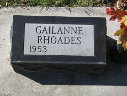
Gailanne “Gail” Lehrkamp Rhoades
| Birth | : | 17 Feb 1953 Carroll, Carroll County, Iowa, USA |
| Death | : | 12 Apr 2021 Blair, Washington County, Nebraska, USA |
| Burial | : | Mount Olivet Cemetery, Carroll, Carroll County, USA |
| Coordinate | : | 42.0536340, -94.8595510 |
| Description | : | Gailanne (Lehrkamp) Rhoades, 68 February 17, 1953 ~ April 12, 2021 #1 After graduating from high school in Carroll, IA she worked at First Data as a key punch operator. She went on to work at First National Bank. In the summer of 1988 she worked construction, then she worked at the Specialty Clinic at Memorial Community Health Service before moving on to Mutual of Omaha. Gail was dedicated to her family and friends; always putting their wellbeing ahead of her own. She was always there for those who needed her. Gail's love of spending time... Read More |
frequently asked questions (FAQ):
-
Where is Gailanne “Gail” Lehrkamp Rhoades's memorial?
Gailanne “Gail” Lehrkamp Rhoades's memorial is located at: Mount Olivet Cemetery, Carroll, Carroll County, USA.
-
When did Gailanne “Gail” Lehrkamp Rhoades death?
Gailanne “Gail” Lehrkamp Rhoades death on 12 Apr 2021 in Blair, Washington County, Nebraska, USA
-
Where are the coordinates of the Gailanne “Gail” Lehrkamp Rhoades's memorial?
Latitude: 42.0536340
Longitude: -94.8595510
Family Members:
Parent

Flowers:


Nearby Cemetories:
1. Mount Olivet Cemetery
Carroll, Carroll County, USA
Coordinate: 42.0536340, -94.8595510
2. Carroll City Cemetery
Carroll, Carroll County, USA
Coordinate: 42.0560963, -94.8599856
3. Holy Angels Cemetery
Carroll County, USA
Coordinate: 42.0014000, -94.9141998
4. Saint Francis Cemetery
Maple River, Carroll County, USA
Coordinate: 42.0969009, -94.9372025
5. Saint Marys Catholic Cemetery
Willey, Carroll County, USA
Coordinate: 41.9783363, -94.8212204
6. Holy Family Cemetery
Lidderdale, Carroll County, USA
Coordinate: 42.1178017, -94.7839966
7. West Lawn Cemetery
Glidden, Carroll County, USA
Coordinate: 42.0649986, -94.7406006
8. Immanuel Cemetery
Lidderdale, Carroll County, USA
Coordinate: 42.1389008, -94.8022003
9. Saint Augustine Cemetery
Halbur, Carroll County, USA
Coordinate: 42.0066986, -94.9744034
10. Our Lady Of Mount Carmel Cemetery
Mount Carmel, Carroll County, USA
Coordinate: 42.1547012, -94.9088974
11. Arcadia Cemetery
Arcadia Township, Carroll County, USA
Coordinate: 42.1000680, -95.0130550
12. East Liberty Cemetery
Lidderdale, Carroll County, USA
Coordinate: 42.1591988, -94.7636032
13. McCurdy Cemetery
Carroll County, USA
Coordinate: 41.9403000, -94.7649994
14. Saint Johns Catholic Cemetery
Arcadia, Carroll County, USA
Coordinate: 42.0855406, -95.0341577
15. Dickson Cemetery
Glidden Township, Carroll County, USA
Coordinate: 42.1074982, -94.6939011
16. Saint Bernards Cemetery
Breda, Carroll County, USA
Coordinate: 42.1786003, -94.9732971
17. Elba Cemetery
Templeton, Carroll County, USA
Coordinate: 41.9068985, -94.9131012
18. Sacred Heart Cemetery
Templeton, Carroll County, USA
Coordinate: 41.9138746, -94.9460994
19. Dedham Cemetery
Dedham, Carroll County, USA
Coordinate: 41.8993988, -94.8225021
20. Saint Josephs Cemetery
Dedham, Carroll County, USA
Coordinate: 41.8993988, -94.8210983
21. North Coon Cemetery
Carroll County, USA
Coordinate: 42.1260986, -94.6716995
22. Old Carrollton Cemetery
Carrollton, Carroll County, USA
Coordinate: 41.9233017, -94.7403030
23. Lanesboro Cemetery
Lanesboro, Carroll County, USA
Coordinate: 42.1810989, -94.7230988
24. Luckow Cemetery
Auburn, Sac County, USA
Coordinate: 42.2168999, -94.9266968