

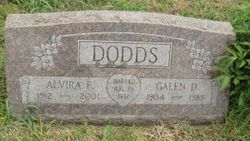
Galen D Dodds
| Birth | : | 18 May 1904 Neuchatel, Nemaha County, Kansas, USA |
| Death | : | 23 Feb 1985 Onaga, Pottawatomie County, Kansas, USA |
| Burial | : | Neuchatel Cemetery, Neuchatel, Nemaha County, USA |
| Coordinate | : | 39.5685196, -96.2015381 |
| Description | : | THE TOPEKA CAPITAL-JOURNAL, Feb. 25, 1985 ONAGA--Galen Dodds, 80, Onaga, died Feb. 23 at an Onaga hospital. Mr. Dodds was a farmer and stockman, and owned the Town and Country Market at Onaga from 1960 to 1968. He had served as chairman of Pottawatomie-Nemaha-Marshal Fire District No. 3. He was born May 18, 1904, in the Neuchatel community north of Onaga, the son of Carl and Irma Surdez Dodds. He was a member of the Congregational Church at Onaga. He married Alvira Talley Aug. 29, 1932, at Lawrence. She survives. Other survivors include a son, Clayton Dodds, Onaga; a daughter, Mrs. Patricia Wagner, Leavenworth;... Read More |
frequently asked questions (FAQ):
-
Where is Galen D Dodds's memorial?
Galen D Dodds's memorial is located at: Neuchatel Cemetery, Neuchatel, Nemaha County, USA.
-
When did Galen D Dodds death?
Galen D Dodds death on 23 Feb 1985 in Onaga, Pottawatomie County, Kansas, USA
-
Where are the coordinates of the Galen D Dodds's memorial?
Latitude: 39.5685196
Longitude: -96.2015381
Family Members:
Parent

Spouse
Siblings
Children
Flowers:


Nearby Cemetories:
1. Saint Pauls Lutheran Cemetery
Duluth, Pottawatomie County, USA
Coordinate: 39.5257988, -96.2311020
2. Saint Patricks Cemetery
Nemaha County, USA
Coordinate: 39.6029091, -96.1459122
3. Mulberry Cemetery
Nemaha County, USA
Coordinate: 39.6314011, -96.2014008
4. Onaga Cemetery
Onaga, Pottawatomie County, USA
Coordinate: 39.5083008, -96.1763992
5. Suterland Cemetery
Onaga, Pottawatomie County, USA
Coordinate: 39.5156600, -96.1542000
6. Home Cemetery
Pottawatomie County, USA
Coordinate: 39.5052986, -96.2219009
7. Pleasant Hill Cemetery
Wheaton, Pottawatomie County, USA
Coordinate: 39.5508000, -96.2864000
8. Regar Cemetery
Onaga, Pottawatomie County, USA
Coordinate: 39.5153008, -96.1358032
9. Saint Josephs Catholic Cemetery
Lillis, Marshall County, USA
Coordinate: 39.6020100, -96.3141800
10. Havensville Cemetery
Havensville, Pottawatomie County, USA
Coordinate: 39.5119019, -96.0828018
11. Saint Luke Lutheran North Cemetery
Wheaton, Pottawatomie County, USA
Coordinate: 39.5037003, -96.3143997
12. Saint Michaels Cemetery
Wheaton, Pottawatomie County, USA
Coordinate: 39.4972000, -96.3146973
13. Wheaton Congregational Cemetery
Wheaton, Pottawatomie County, USA
Coordinate: 39.4935989, -96.3133011
14. America City Cemetery
America City, Nemaha County, USA
Coordinate: 39.5727997, -96.0421982
15. Saint Lukes Lutheran Cemetery
Pottawatomie County, USA
Coordinate: 39.4500008, -96.2581024
16. Vienna Cemetery
Pottawatomie County, USA
Coordinate: 39.4472198, -96.1466675
17. Maple Grove Cemetery
Wheaton, Pottawatomie County, USA
Coordinate: 39.5233002, -96.3591995
18. Rose Hill Cemetery
Nemaha County, USA
Coordinate: 39.5811005, -96.0130997
19. Berg Cemetery
Blaine, Pottawatomie County, USA
Coordinate: 39.5370800, -96.3883700
20. Fairview Cemetery
Onaga, Pottawatomie County, USA
Coordinate: 39.4356600, -96.1101300
21. Saint Patricks Cemetery
Corning, Nemaha County, USA
Coordinate: 39.6521988, -96.0250015
22. Corning Cemetery
Corning, Nemaha County, USA
Coordinate: 39.6632996, -96.0314026
23. Mount Hope Cemetery
Frankfort, Marshall County, USA
Coordinate: 39.6025009, -96.4072037
24. Vermillion Cemetery
Vermillion, Marshall County, USA
Coordinate: 39.7235985, -96.2763977