
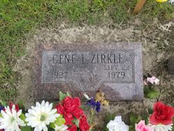
Gene L. Zirkle
| Birth | : | 8 Apr 1927 Topeka, Shawnee County, Kansas, USA |
| Death | : | Sep 1979 Topeka, Shawnee County, Kansas, USA |
| Burial | : | Pinegrove Memorial Park, Minchinbury, Blacktown City, Australia |
| Coordinate | : | -33.7886400, 150.8478990 |
| Description | : | Son Verla Faye Allensworth and Edward Everette Zirkle. 2nd husband of M. Dolores Griffin. Married on 17 May 1948. *************************************** Obituary: Gene L. Zirkle Gene L. Zirkle, 52, Burlingame [KS], died Saturday night in a Topeka hospital. He had cancer. He was born April 8, 1927 in Topeka. Mr. Zirkle served in the U.S. Navy for two years and then served in the Army Reserve for five years. He was a construction worker for several years, worked with Topeka Supply Depot, and worked for the last 14 years at Goodyear Rubber and Tire Co. He was a member of the First Southern Baptist Church, Burlingame. On May 7, 1948,... Read More |
frequently asked questions (FAQ):
-
Where is Gene L. Zirkle's memorial?
Gene L. Zirkle's memorial is located at: Pinegrove Memorial Park, Minchinbury, Blacktown City, Australia.
-
When did Gene L. Zirkle death?
Gene L. Zirkle death on Sep 1979 in Topeka, Shawnee County, Kansas, USA
-
Where are the coordinates of the Gene L. Zirkle's memorial?
Latitude: -33.7886400
Longitude: 150.8478990
Family Members:
Parent

Spouse
Siblings
Flowers:


Nearby Cemetories:
1. Pinegrove Memorial Park
Minchinbury, Blacktown City, Australia
Coordinate: -33.7886400, 150.8478990
2. Rooty Hill Presbyterian
Rooty Hill, Blacktown City, Australia
Coordinate: -33.7806700, 150.8513800
3. St Marys General Cemetery
St Marys, Penrith City, Australia
Coordinate: -33.7727050, 150.7878490
4. St. Bartholomew's Anglican Church Cemetery
Prospect, Blacktown City, Australia
Coordinate: -33.8045110, 150.9175750
5. St Mary Magdalene Anglican Churchyard
St Marys, Penrith City, Australia
Coordinate: -33.7705630, 150.7776050
6. Smithfield General Cemetery
Smithfield, Fairfield City, Australia
Coordinate: -33.8497800, 150.9252800
7. Smithfield Uniting Church Cemetery
Smithfield, Fairfield City, Australia
Coordinate: -33.8525100, 150.9373500
8. Smithfield Baptist Churchyard
Smithfield, Fairfield City, Australia
Coordinate: -33.8529380, 150.9374430
9. Smithfield Anglican
Smithfield, Fairfield City, Australia
Coordinate: -33.8536220, 150.9383850
10. Riverstone Cemetery
Riverstone, Blacktown City, Australia
Coordinate: -33.6853450, 150.8480790
11. Clydesdale Property
Marsden Park, Blacktown City, Australia
Coordinate: -33.6848034, 150.8077757
12. Castlebrook Memorial Park
Rouse Hill, Blacktown City, Australia
Coordinate: -33.6948310, 150.9219790
13. Penrith General Cemetery
Kingswood, Penrith City, Australia
Coordinate: -33.7561290, 150.7186600
14. St Phillips Church Cemetery
Marsden Park, Blacktown City, Australia
Coordinate: -33.6793810, 150.8167060
15. Animal Memorial Cemetery & Crematorium
Berkshire Park, Penrith City, Australia
Coordinate: -33.6887690, 150.7850410
16. Kemps Creek Cemetery and Crematorium
Kemps Creek, Liverpool City, Australia
Coordinate: -33.8958260, 150.7793870
17. Rouse Hill Anglican Cemetery
Rouse Hill, Blacktown City, Australia
Coordinate: -33.6810100, 150.9174190
18. St. Stephen's Penrith Anglican Church Columbarium
Penrith, Penrith City, Australia
Coordinate: -33.7552554, 150.7036009
19. St Stephens Anglican Cemetery
Penrith, Penrith City, Australia
Coordinate: -33.7558960, 150.7030470
20. Mays Hill Cemetery
Cumberland Council, Australia
Coordinate: -33.8193430, 150.9934850
21. Merrylands Anglican Church Columbarium
Merrylands, Cumberland Council, Australia
Coordinate: -33.8401100, 150.9870800
22. Lone Graves
Parramatta, City of Parramatta Council, Australia
Coordinate: -33.8186610, 150.9967800
23. St Nicholas of Myra Catholic Church, Penrith
Penrith, Penrith City, Australia
Coordinate: -33.7544695, 150.7000862
24. St. John's Cemetery
Parramatta, City of Parramatta Council, Australia
Coordinate: -33.8168010, 150.9983310