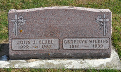
Geneieve Bluel Wilkins
| Birth | : | 18 Aug 1867 Key West, Dubuque County, Iowa, USA |
| Death | : | 30 Jan 1939 Rockwell, Cerro Gordo County, Iowa, USA |
| Burial | : | Sacred Heart Cemetery, Rockwell, Cerro Gordo County, USA |
| Coordinate | : | 42.9592018, -93.1913986 |
| Description | : | Genevieve Bluel Wilkins was listed as the mother of Elizabeth A. Josman in the 1925 Iowa State Census and her father was listed as Jerry Wilkins. Elizabeth was born in the state of Washington and in 1900, she was living with Jim B. Wilkins (transcription error by Ancestry and with further review, it is actually Jerry B). There is no mother listed; however, Jennie Gross is listed as a widowed housekeeper living with the family. Her birth date was Aug 1867 and she was born in Iowa. Her father was born in Iowa and her mother was born... Read More |
frequently asked questions (FAQ):
-
Where is Geneieve Bluel Wilkins's memorial?
Geneieve Bluel Wilkins's memorial is located at: Sacred Heart Cemetery, Rockwell, Cerro Gordo County, USA.
-
When did Geneieve Bluel Wilkins death?
Geneieve Bluel Wilkins death on 30 Jan 1939 in Rockwell, Cerro Gordo County, Iowa, USA
-
Where are the coordinates of the Geneieve Bluel Wilkins's memorial?
Latitude: 42.9592018
Longitude: -93.1913986
Family Members:
Parent
Siblings
Flowers:
Nearby Cemetories:
1. Sacred Heart Cemetery
Rockwell, Cerro Gordo County, USA
Coordinate: 42.9592018, -93.1913986
2. Rockwell Cemetery
Rockwell, Cerro Gordo County, USA
Coordinate: 42.9786000, -93.1919000
3. Hillside Cemetery
Sheffield, Franklin County, USA
Coordinate: 42.9006004, -93.2007980
4. Saint John Zion Cemetery
Sheffield, Franklin County, USA
Coordinate: 42.8969002, -93.1472015
5. Shobes Grove Cemetery
Franklin County, USA
Coordinate: 42.9000015, -93.2722168
6. Pleasant Valley Township Cemetery
Swaledale, Cerro Gordo County, USA
Coordinate: 42.9505615, -93.3216705
7. West Fork Cemetery
Franklin County, USA
Coordinate: 42.8918991, -93.0836029
8. Mount Vernon Cemetery
Mount Vernon Township, Cerro Gordo County, USA
Coordinate: 43.0374985, -93.3181000
9. Saint Patricks Catholic Cemetery
Dougherty, Cerro Gordo County, USA
Coordinate: 42.9227791, -93.0294418
10. Way Side Cemetery
Chapin, Franklin County, USA
Coordinate: 42.8293991, -93.2225037
11. Owens Grove Cemetery
Cerro Gordo County, USA
Coordinate: 43.0825005, -93.1144180
12. Richland Lutheran Cemetery
Thornton, Cerro Gordo County, USA
Coordinate: 42.9086113, -93.3683319
13. Pleasant View Cemetery
Thornton, Cerro Gordo County, USA
Coordinate: 42.9524994, -93.3897018
14. Old Chapin Cemetery
Chapin, Franklin County, USA
Coordinate: 42.8232994, -93.2624969
15. Zion Reformed Church Cemetery
Franklin County, USA
Coordinate: 42.8413887, -93.3188934
16. IOOF Cemetery
Mason City, Cerro Gordo County, USA
Coordinate: 43.1336975, -93.2139130
17. Elmwood Saint Joseph Cemetery
Mason City, Cerro Gordo County, USA
Coordinate: 43.1399994, -93.2067032
18. Saint Johns Episcopal Church Columbarium
Mason City, Cerro Gordo County, USA
Coordinate: 43.1528900, -93.1980730
19. First Congregational UCC Columbarium
Mason City, Cerro Gordo County, USA
Coordinate: 43.1529720, -93.1990410
20. Trinity Lutheran Cemetery
Hampton, Franklin County, USA
Coordinate: 42.7667007, -93.2518997
21. Memorial Park Cemetery
Mason City, Cerro Gordo County, USA
Coordinate: 43.1469002, -93.2936020
22. Hansell Cemetery
Franklin County, USA
Coordinate: 42.7666702, -93.1047211
23. Riverside Cemetery
Rockford, Floyd County, USA
Coordinate: 43.0578003, -92.9464035
24. Marion Center Cemetery
Latimer, Franklin County, USA
Coordinate: 42.7738991, -93.3178024


