

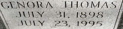
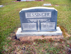
Genora Oleigan Thomas Bessinger
| Birth | : | 31 Jul 1898 Orangeburg County, South Carolina, USA |
| Death | : | 23 Jul 1995 Charleston, Charleston County, South Carolina, USA |
| Burial | : | Millicent Cemetery, Millicent, Wattle Range Council, Australia |
| Coordinate | : | -37.6184335, 140.3770980 |
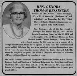
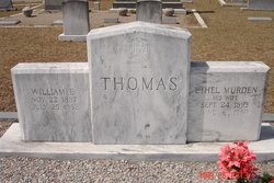
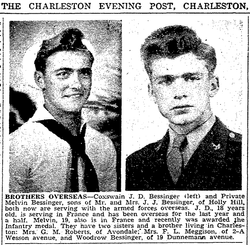
| Description | : | Genora Thomas Bessinger, 96, of Charleston, died Sunday in a local hospital. The funeral will be at 11 a.m. Wednesday in Pinecrest Baptist Church. Burial, directed by Stuhr's Downtown Chapel, will be at 2 p.m. in Holly Hill Cemetery. Mrs. Bessinger was born in Orangeburg County, a daughter of Richard Thomas and Mary E. Sturkey Thomas. She attended Orangeburg County schools and was a member of Pinecrest Baptist Church. She was the widow of Joe Jacob Bessinger. Surviving are five sons, Melvin Bessinger of James Island, Joe D. Bessinger of Mount Pleasant, L. Maurice Bessinger of Columbia, Thomas E. Bessinger... Read More |
frequently asked questions (FAQ):
-
Where is Genora Oleigan Thomas Bessinger's memorial?
Genora Oleigan Thomas Bessinger's memorial is located at: Millicent Cemetery, Millicent, Wattle Range Council, Australia.
-
When did Genora Oleigan Thomas Bessinger death?
Genora Oleigan Thomas Bessinger death on 23 Jul 1995 in Charleston, Charleston County, South Carolina, USA
-
Where are the coordinates of the Genora Oleigan Thomas Bessinger's memorial?
Latitude: -37.6184335
Longitude: 140.3770980
Family Members:
Parent

Spouse
Siblings
Children

Flowers:


Nearby Cemetories:
1. Millicent Cemetery
Millicent, Wattle Range Council, Australia
Coordinate: -37.6184335, 140.3770980
2. Kalangadoo Cemetery
Kalangadoo, Wattle Range Council, Australia
Coordinate: -37.5694190, 140.7045780
3. Beachport Cemetery
Beachport, Wattle Range Council, Australia
Coordinate: -37.4725340, 140.0475120
4. Carinya Gardens
Mount Gambier, Mount Gambier City, Australia
Coordinate: -37.8370330, 140.7494970
5. Pioneer Park
Mount Gambier, Mount Gambier City, Australia
Coordinate: -37.8348290, 140.7840010
6. Mieschel Park
Mount Gambier, Mount Gambier City, Australia
Coordinate: -37.8374980, 140.7855890
7. Lake Terrace Cemetery
Mount Gambier, Mount Gambier City, Australia
Coordinate: -37.8425950, 140.7854720
8. Penola Cemetery
Penola, Wattle Range Council, Australia
Coordinate: -37.4009210, 140.8362800
9. Penola Old Cemetery
Penola, Wattle Range Council, Australia
Coordinate: -37.3670740, 140.8412400
10. Port MacDonnell Lighthouse Cemetery
Port MacDonnell, District Council of Grant, Australia
Coordinate: -38.0558330, 140.6630560
11. Moyhall Homestead
Naracoorte Lucindale Council, Australia
Coordinate: -37.0585750, 140.6699470
12. Heathfield Cemetery
Lake Mundi, Glenelg Shire, Australia
Coordinate: -37.5713233, 141.1436213
13. Strathdownie Cemetery
Strathdownie, Glenelg Shire, Australia
Coordinate: -37.7174000, 141.1676280
14. Lucindale Cemetery
Lucindale, Naracoorte Lucindale Council, Australia
Coordinate: -36.9696190, 140.3797090
15. Nelson Cemetery
Nelson, Glenelg Shire, Australia
Coordinate: -38.0359977, 141.0123516
16. Robe Cemetery
Robe, District Council of Robe, Australia
Coordinate: -37.1676290, 139.7506190
17. Dergholm Cemetery
Dergholm, West Wimmera Shire, Australia
Coordinate: -37.3717520, 141.2253000
18. Naracoorte Cemetery
Naracoorte, Naracoorte Lucindale Council, Australia
Coordinate: -36.9460270, 140.7302250
19. Dartmoor Cemetery
Dartmoor, Glenelg Shire, Australia
Coordinate: -37.9148220, 141.2491380
20. Hynam Cemetery
Naracoorte Lucindale Council, Australia
Coordinate: -36.9393410, 140.8490120
21. Casterton Old Cemetery
Casterton, Glenelg Shire, Australia
Coordinate: -37.5948850, 141.3700380
22. Drik Drik Cemetery
Drik Drik, Glenelg Shire, Australia
Coordinate: -37.9858333, 141.2952778
23. Casterton Cemetery
Casterton, Glenelg Shire, Australia
Coordinate: -37.5992440, 141.4088270
24. Sandford Cemetery
Sandford, Glenelg Shire, Australia
Coordinate: -37.6290998, 141.4562576