
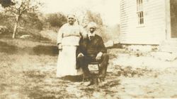
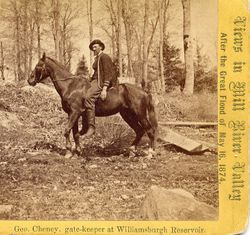
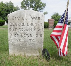

George Cheney
| Birth | : | Jun 1844 |
| Death | : | 8 Oct 1918 |
| Burial | : | Thompsonville Cemetery, Enfield, Hartford County, USA |
| Coordinate | : | 42.0054893, -72.6010895 |
| Description | : | The first recorded dam failure in the United States occurred on May 16, 1874, in Williamsburg, Massachusetts. A landslide shattered a 43-foot dam on the Mill Creek, a tributary of the Connecticut River, resulting in the death of 144 people and $1 million in damage. Surely this is a small number compared to what could have been without the heroic actions of Mr Cheney. Known as the Revere of Williamsburg, MA, Mr Cheney, age 35, was the gatekeeper for the Williamsburg dam that provided power for several factories in the towns downstream. On the morning of May 16, 1874,... Read More |
frequently asked questions (FAQ):
-
Where is George Cheney's memorial?
George Cheney's memorial is located at: Thompsonville Cemetery, Enfield, Hartford County, USA.
-
When did George Cheney death?
George Cheney death on 8 Oct 1918 in
-
Where are the coordinates of the George Cheney's memorial?
Latitude: 42.0054893
Longitude: -72.6010895
Family Members:
Parent
Spouse

Children
Flowers:


Nearby Cemetories:
1. Thompsonville Cemetery
Enfield, Hartford County, USA
Coordinate: 42.0054893, -72.6010895
2. Old Saint Patricks Cemetery
Enfield, Hartford County, USA
Coordinate: 42.0052528, -72.6022186
3. Austin Cemetery
Suffield, Hartford County, USA
Coordinate: 42.0075333, -72.6083833
4. Holy Cross Cemetery
Enfield, Hartford County, USA
Coordinate: 42.0035362, -72.5912170
5. Saint Adalbert Cemetery
Enfield, Hartford County, USA
Coordinate: 42.0026207, -72.5878754
6. Enfield Street Cemetery
Enfield, Hartford County, USA
Coordinate: 41.9844017, -72.5916977
7. Sikes Cemetery
Suffield, Hartford County, USA
Coordinate: 42.0268010, -72.6153050
8. Woodlawn Cemetery
Suffield, Hartford County, USA
Coordinate: 41.9771996, -72.6311035
9. Massachusetts Veterans Memorial Cemetery
Agawam, Hampden County, USA
Coordinate: 42.0461884, -72.6164169
10. Old Center Cemetery
Suffield, Hartford County, USA
Coordinate: 41.9828186, -72.6527100
11. New Hazardville Cemetery
Hazardville, Hartford County, USA
Coordinate: 41.9883804, -72.5450592
12. Longmeadow Cemetery
Longmeadow, Hampden County, USA
Coordinate: 42.0495262, -72.5791397
13. Islamic Center Cemetery
Enfield, Hartford County, USA
Coordinate: 41.9968109, -72.5389862
14. Old Hazardville Cemetery
Hazardville, Hartford County, USA
Coordinate: 41.9867897, -72.5409393
15. New Saint Patricks Cemetery
Enfield, Hartford County, USA
Coordinate: 41.9558100, -72.6030700
16. Saint Josephs Cemetery
Suffield, Hartford County, USA
Coordinate: 41.9947014, -72.6750031
17. Saint Bernard's Cemetery
Enfield, Hartford County, USA
Coordinate: 41.9930992, -72.5274963
18. First Baptist Church Cemetery
Suffield, Hartford County, USA
Coordinate: 42.0131658, -72.6775383
19. Zions Hill Cemetery
Suffield, Hartford County, USA
Coordinate: 42.0132713, -72.6775894
20. Saint Andrews Episcopal Church Columbarium
Longmeadow, Hampden County, USA
Coordinate: 42.0616680, -72.5793800
21. Agawam Center Cemetery
Agawam, Hampden County, USA
Coordinate: 42.0659700, -72.6162000
22. Shaker Cemetery
Enfield, Hartford County, USA
Coordinate: 42.0141400, -72.5161600
23. Smith Family Cemetery
Feeding Hills, Hampden County, USA
Coordinate: 42.0412460, -72.6722860
24. King Street Cemetery
Enfield, Hartford County, USA
Coordinate: 41.9389000, -72.6055984