
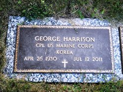
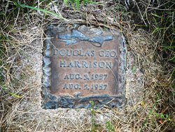
George Harrison
| Birth | : | 26 Apr 1930 Emmetsburg, Palo Alto County, Iowa, USA |
| Death | : | 12 Jul 2011 Clay County, Iowa, USA |
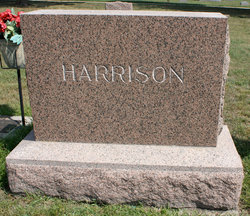
| Burial | : | North Lawn Cemetery, Spencer, Clay County, USA |
| Coordinate | : | 43.1600000, -95.1470000 |
| Description | : | George Harrison, the son of George and Myrtle (Harvey) Harrison was born April 27, 1930 in Emmetsburg, Iowa. He attended school in Cylinder and graduated from Cylinder High School in 1948. He served in the U.S. Marine Corp from 1952 until his honorable discharge in 1954. George married Donna Fiedler on April 28, 1952. After his discharge from the Marines, he worked on a farm near Milford, Iowa. In 1960, they moved to Peterson, Iowa, where he worked for the Peterson Hatchery. He then worked for Wetherell Sand and Gravel in Peterson, until his retirement in 2009. George was a... Read More |
frequently asked questions (FAQ):
-
Where is George Harrison's memorial?
George Harrison's memorial is located at: North Lawn Cemetery, Spencer, Clay County, USA.
-
When did George Harrison death?
George Harrison death on 12 Jul 2011 in Clay County, Iowa, USA
-
Where are the coordinates of the George Harrison's memorial?
Latitude: 43.1600000
Longitude: -95.1470000
Family Members:
Parent

Spouse
Siblings


Children
Flowers:


Nearby Cemetories:
1. North Lawn Cemetery
Spencer, Clay County, USA
Coordinate: 43.1600000, -95.1470000
2. Dewey Readmore Books Memorial
Spencer, Clay County, USA
Coordinate: 43.1403999, -95.1443024
3. Riverside Cemetery
Spencer, Clay County, USA
Coordinate: 43.1441994, -95.1671982
4. Fairview Cemetery
Clay County, USA
Coordinate: 43.1899986, -95.0800018
5. Evergreen Cemetery
Clay County, USA
Coordinate: 43.2052994, -95.2086029
6. Dickens Cemetery
Dickens, Clay County, USA
Coordinate: 43.1280000, -95.0155000
7. Swedish Lutheran Cemetery
Royal, Clay County, USA
Coordinate: 43.0683000, -95.2350000
8. Little Sioux Lutheran Cemetery
Milford, Dickinson County, USA
Coordinate: 43.2702065, -95.2109528
9. Rosehill Cemetery
Clay County, USA
Coordinate: 43.0368996, -95.0919037
10. First Reformed Cemetery
Clay County, USA
Coordinate: 43.2399500, -95.2889000
11. Lone Tree Cemetery
Everly, Clay County, USA
Coordinate: 43.1411018, -95.3347015
12. Milford Cemetery
Milford, Dickinson County, USA
Coordinate: 43.3092003, -95.1481018
13. Lincoln Cemetery
Rossie, Clay County, USA
Coordinate: 43.0111008, -95.2313995
14. Calvary Cemetery
Milford, Dickinson County, USA
Coordinate: 43.3213997, -95.1688995
15. Logan Township Cemetery
Clay County, USA
Coordinate: 43.0489006, -94.9747009
16. Liberty Cemetery
Greenville, Clay County, USA
Coordinate: 42.9897003, -95.1417007
17. Willow Creek Cemetery
Royal, Clay County, USA
Coordinate: 43.0214005, -95.2885971
18. Clay Center Cemetery
Royal, Clay County, USA
Coordinate: 43.0410995, -95.3272018
19. TriMello Cemetery
Royal, Clay County, USA
Coordinate: 43.0682983, -95.3728027
20. Crown Hill Cemetery
Ruthven, Palo Alto County, USA
Coordinate: 43.1328011, -94.8878021
21. Calvary Cemetery
Ruthven, Palo Alto County, USA
Coordinate: 43.1314011, -94.8869019
22. Zion Methodist Cemetery
Clay County, USA
Coordinate: 42.9808006, -95.2497025
23. Westport Cemetery
Dickinson County, USA
Coordinate: 43.3130989, -95.3289032
24. Okoboji Cemetery
Arnolds Park, Dickinson County, USA
Coordinate: 43.3649406, -95.1303558