
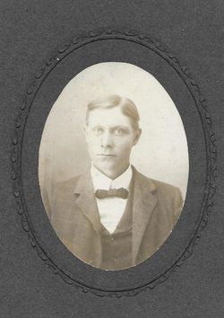
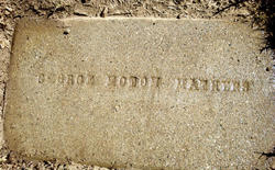
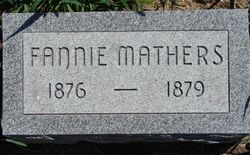
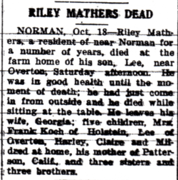
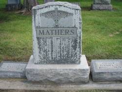
George Nolton Mathers
| Birth | : | 17 Mar 1880 Heartwell, Kearney County, Nebraska, USA |
| Death | : | 1 Dec 1946 Patterson, Stanislaus County, California, USA |
| Burial | : | Patterson District Cemetery, Patterson, Stanislaus County, USA |
| Coordinate | : | 37.5268135, -121.1728287 |
| Plot | : | D3 33 |
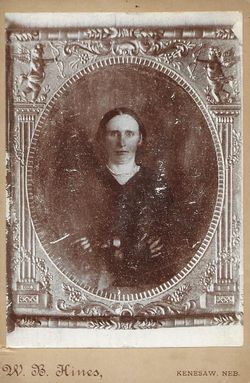
| Description | : | George was the son of Josiah and Mary Jane (Conyers) Mathers. He moved to Stanislaus Co., CA in 1927. |
frequently asked questions (FAQ):
-
Where is George Nolton Mathers's memorial?
George Nolton Mathers's memorial is located at: Patterson District Cemetery, Patterson, Stanislaus County, USA.
-
When did George Nolton Mathers death?
George Nolton Mathers death on 1 Dec 1946 in Patterson, Stanislaus County, California, USA
-
Where are the coordinates of the George Nolton Mathers's memorial?
Latitude: 37.5268135
Longitude: -121.1728287
Family Members:
Parent
Siblings

Flowers:


Nearby Cemetories:
1. Patterson District Cemetery
Patterson, Stanislaus County, USA
Coordinate: 37.5268135, -121.1728287
2. Grayson Cemetery
Grayson, Stanislaus County, USA
Coordinate: 37.5594559, -121.1802826
3. Good Shepherd Catholic Cemetery
Modesto, Stanislaus County, USA
Coordinate: 37.6853130, -121.0672890
4. Ceres Memorial Park
Ceres, Stanislaus County, USA
Coordinate: 37.5958214, -120.9634399
5. Wood Colony Cemetery
Salida, Stanislaus County, USA
Coordinate: 37.6893730, -121.0682144
6. Modesto Citizens Cemetery
Modesto, Stanislaus County, USA
Coordinate: 37.6472930, -120.9845570
7. Modesto Pioneer Cemetery
Modesto, Stanislaus County, USA
Coordinate: 37.6473350, -120.9829040
8. Acacia Memorial Park
Modesto, Stanislaus County, USA
Coordinate: 37.6481080, -120.9836610
9. Saint Stanislaus Catholic Cemetery
Modesto, Stanislaus County, USA
Coordinate: 37.6473610, -120.9808440
10. Modesto County Cemetery
Modesto, Stanislaus County, USA
Coordinate: 37.6492400, -120.9813800
11. Brichetto Tomb
San Joaquin County, USA
Coordinate: 37.6272011, -121.3871994
12. Hills Ferry Cemetery
Newman, Stanislaus County, USA
Coordinate: 37.3321991, -121.0496979
13. Ripon Cemetery
Ripon, San Joaquin County, USA
Coordinate: 37.7420311, -121.1238708
14. Lakewood Memorial Park
Hughson, Stanislaus County, USA
Coordinate: 37.6199760, -120.8975983
15. Turlock Memorial Park
Turlock, Stanislaus County, USA
Coordinate: 37.4937592, -120.8659821
16. North Hilmar Cemetery
Hilmar, Merced County, USA
Coordinate: 37.4146614, -120.8864288
17. Saint Francis Episcopal Church Columbarium
Turlock, Stanislaus County, USA
Coordinate: 37.5014300, -120.8368400
18. Colonel James J Stevinson Cemetery
Stevinson, Merced County, USA
Coordinate: 37.3572044, -120.9112320
19. South Hilmar Cemetery
Hilmar, Merced County, USA
Coordinate: 37.3802681, -120.8868408
20. Tracy Mausoleum
Tracy, San Joaquin County, USA
Coordinate: 37.7250214, -121.4150696
21. Tracy Public Cemetery
Tracy, San Joaquin County, USA
Coordinate: 37.7251358, -121.4189453
22. Denair Cemetery
Denair, Stanislaus County, USA
Coordinate: 37.5293999, -120.8199997
23. Stevinson Sunnyside Cemetery
Stevinson, Merced County, USA
Coordinate: 37.3292007, -120.9231033
24. Saint John's Catholic Cemetery
Escalon, San Joaquin County, USA
Coordinate: 37.7994537, -121.0705185