

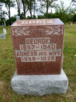
George Roop
| Birth | : | 6 Jan 1857 DeKalb County, Indiana, USA |
| Death | : | 20 Jan 1940 Garrett, DeKalb County, Indiana, USA |
| Burial | : | St. Giles Churchyard, Colby, North Norfolk District, England |
| Coordinate | : | 52.8318190, 1.2945700 |
frequently asked questions (FAQ):
-
Where is George Roop's memorial?
George Roop's memorial is located at: St. Giles Churchyard, Colby, North Norfolk District, England.
-
When did George Roop death?
George Roop death on 20 Jan 1940 in Garrett, DeKalb County, Indiana, USA
-
Where are the coordinates of the George Roop's memorial?
Latitude: 52.8318190
Longitude: 1.2945700
Family Members:

Flowers:


Nearby Cemetories:
1. St. Giles Churchyard
Colby, North Norfolk District, England
Coordinate: 52.8318190, 1.2945700
2. St. Botolph Churchyard
Banningham, North Norfolk District, England
Coordinate: 52.8170850, 1.2865060
3. St. Mary's Churchyard
Erpingham, North Norfolk District, England
Coordinate: 52.8338580, 1.2626100
4. St. Ethelbert's Church Burial Ground
Alby with Thwaite, North Norfolk District, England
Coordinate: 52.8548760, 1.2701850
5. St Andrew's Churchyard
Gunton, North Norfolk District, England
Coordinate: 52.8584910, 1.3097280
6. All Saints Churchyard
Alby with Thwaite, North Norfolk District, England
Coordinate: 52.8533000, 1.2555000
7. St. Andrews Church Burial Ground
Felmingham, North Norfolk District, England
Coordinate: 52.8139100, 1.3391320
8. St. Mary's Churchyard
Antingham, North Norfolk District, England
Coordinate: 52.8464655, 1.3436395
9. Our Lady and St. Margaret's Churchyard
Calthorpe, North Norfolk District, England
Coordinate: 52.8391540, 1.2373828
10. St Peter & St Paul's Church
Tuttington, Broadland District, England
Coordinate: 52.7962090, 1.3009760
11. St. Bartholomew Churchyard
Hanworth, North Norfolk District, England
Coordinate: 52.8664290, 1.2718830
12. St. Mary's Churchyard
Aldborough, North Norfolk District, England
Coordinate: 52.8575340, 1.2354660
13. St Andrew Churchyard
Blickling, Broadland District, England
Coordinate: 52.8095370, 1.2311760
14. Blickling Hall
Blickling, Broadland District, England
Coordinate: 52.8095474, 1.2310860
15. St. Michael and All Angels Churchyard
Aylsham, Broadland District, England
Coordinate: 52.7960690, 1.2506530
16. Silvergate Lane Cemetery
Blickling, Broadland District, England
Coordinate: 52.8075334, 1.2305140
17. St Giles Churchyard
Bradfield, North Norfolk District, England
Coordinate: 52.8493740, 1.3667290
18. St. Mary Churchyard
Roughton, North Norfolk District, England
Coordinate: 52.8801901, 1.2976948
19. Aylsham Cemetery
Aylsham, Broadland District, England
Coordinate: 52.7883400, 1.2540900
20. St. Mary's Churchyard
Burgh Next Aylsham, Broadland District, England
Coordinate: 52.7775114, 1.2865926
21. Saint Nicholas Churchyard
North Walsham, North Norfolk District, England
Coordinate: 52.8216050, 1.3873600
22. St. Peter's Churchyard
Brampton, Broadland District, England
Coordinate: 52.7733970, 1.2891100
23. St. Andrew's Churchyard
Metton, North Norfolk District, England
Coordinate: 52.8880460, 1.2670590
24. North Walsham New Cemetery
North Walsham, North Norfolk District, England
Coordinate: 52.8242410, 1.3913360