
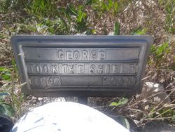
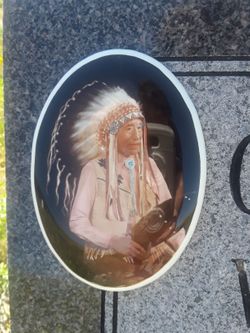
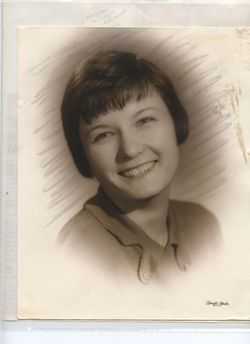
George “Sonny” Took the shield Jr.
| Birth | : | 21 Jan 1947 Savoy, Blaine County, Montana, USA |
| Death | : | 26 Jan 2000 Fort Belknap Agency, Blaine County, Montana, USA |
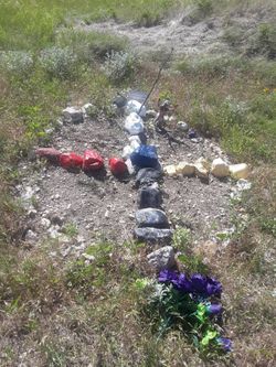
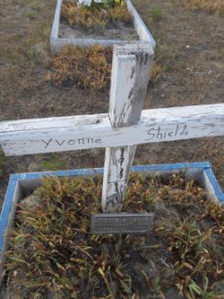
| Burial | : | Big Warm Cemetery, Blaine County, USA |
| Coordinate | : | 48.0071983, -108.4655991 |
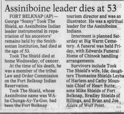
| Description | : | George "Sonny" Took the Shield, 53, was the son of George Shields Sr. and Elizabeth Lodge. Married to Ida Took the Shield. |
frequently asked questions (FAQ):
-
Where is George “Sonny” Took the shield Jr.'s memorial?
George “Sonny” Took the shield Jr.'s memorial is located at: Big Warm Cemetery, Blaine County, USA.
-
When did George “Sonny” Took the shield Jr. death?
George “Sonny” Took the shield Jr. death on 26 Jan 2000 in Fort Belknap Agency, Blaine County, Montana, USA
-
Where are the coordinates of the George “Sonny” Took the shield Jr.'s memorial?
Latitude: 48.0071983
Longitude: -108.4655991
Family Members:
Parent
Spouse
Siblings


Nearby Cemetories:
1. Big Warm Cemetery
Blaine County, USA
Coordinate: 48.0071983, -108.4655991
2. Chopwoid Cemetery
Blaine County, USA
Coordinate: 48.0071983, -108.4772034
3. Kirkaldie Cemetery
Blaine County, USA
Coordinate: 48.0266991, -108.4505997
4. Lodge Pole Cemetery
Lodge Pole, Blaine County, USA
Coordinate: 48.0371430, -108.5260870
5. Messerly Cemetery
Blaine County, USA
Coordinate: 48.0630989, -108.4385986
6. Zortman Cemetery
Phillips County, USA
Coordinate: 47.9185710, -108.5166620
7. Saint Pauls Mission Cemetery
Hays, Blaine County, USA
Coordinate: 47.9745000, -108.6718000
8. Hawley Family Cemetery
Hays, Blaine County, USA
Coordinate: 47.9889984, -108.6940002
9. Landusky Cemetery
Landusky, Phillips County, USA
Coordinate: 47.8958015, -108.6294022
10. Hays Cemetery
Hays, Blaine County, USA
Coordinate: 47.9894200, -108.7123900
11. Pike Landusky Gravesite
Phillips County, USA
Coordinate: 47.8821500, -108.6291000
12. Midale Cemetery
Phillips County, USA
Coordinate: 47.9096985, -108.1063995
13. Graveyard Hill Cemetery
Phillips County, USA
Coordinate: 48.3847008, -108.3638992
14. Fort Belknap Cemetery
Harlem, Blaine County, USA
Coordinate: 48.4347210, -108.5595860
15. Hillside Cemetery
Dodson, Phillips County, USA
Coordinate: 48.4122009, -108.2352982
16. Sacred Heart Catholic Cemetery
Fort Belknap Agency, Blaine County, USA
Coordinate: 48.4489000, -108.6582000
17. Scandia Lutheran Cemetery
Malta, Phillips County, USA
Coordinate: 48.1885210, -107.7866940
18. Agency Cemetery
Fort Belknap Agency, Blaine County, USA
Coordinate: 48.4767000, -108.7702000
19. Malta City Cemetery
Malta, Phillips County, USA
Coordinate: 48.3516150, -107.8667200
20. Cleveland Cemetery
Cleveland, Blaine County, USA
Coordinate: 48.2714500, -109.1517000
21. Harlem Cemetery
Harlem, Blaine County, USA
Coordinate: 48.5444700, -108.7817200
22. North Harlem Colony Cemetery
North Harlem Colony, Blaine County, USA
Coordinate: 48.5855560, -108.7558330
23. Bear Paw Battlefield
Chinook, Blaine County, USA
Coordinate: 48.3780070, -109.2121290
24. Alice Nash Memorial Cemetery
Blaine County, USA
Coordinate: 47.8850000, -109.3748000