
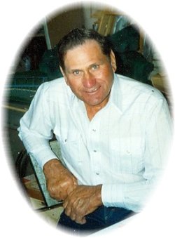
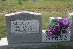


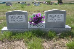
Gerald Richard Gibbs
| Birth | : | 23 Jul 1925 Miles City, Custer County, Montana, USA |
| Death | : | 21 Mar 2015 Glendive, Dawson County, Montana, USA |
| Burial | : | Pioneer Cemetery, Jordan, Garfield County, USA |
| Coordinate | : | 47.3244019, -106.9238968 |
| Description | : | Gerald R. Gibbs, age 89, of Jordan, MT passed away on March 21, 2015 at the Eastern Montana Veteran Home in Glendive, MT. Gerald Richard Gibbs was born on July 23, 1925 in Miles City, MT, the son of Roy and Nora (Leibole) Gibbs. Gerald grew up on the family ranch near Jordan where he attended various country schools; he also attended school in Miles City for a short period of time. From an early age Gerald was an independent hard worker. The cold winter of 1935 he began a paper route so he could earn money for... Read More |
frequently asked questions (FAQ):
-
Where is Gerald Richard Gibbs's memorial?
Gerald Richard Gibbs's memorial is located at: Pioneer Cemetery, Jordan, Garfield County, USA.
-
When did Gerald Richard Gibbs death?
Gerald Richard Gibbs death on 21 Mar 2015 in Glendive, Dawson County, Montana, USA
-
Where are the coordinates of the Gerald Richard Gibbs's memorial?
Latitude: 47.3244019
Longitude: -106.9238968
Family Members:
Parent

Spouse
Siblings

Flowers:


Nearby Cemetories:
1. Pioneer Cemetery
Jordan, Garfield County, USA
Coordinate: 47.3244019, -106.9238968
2. Greenridge Cemetery
Jordan, Garfield County, USA
Coordinate: 47.3389015, -106.8946991
3. Hinther Cemetery
Garfield County, USA
Coordinate: 47.2685000, -107.0218000
4. Butte Creek Cemetery
Garfield County, USA
Coordinate: 47.4777985, -107.2341995
5. Steve Forks Cemetery
Garfield County, USA
Coordinate: 47.2627983, -107.3321991
6. Cohagen Cemetery
Cohagen, Garfield County, USA
Coordinate: 47.0772018, -106.6232986
7. Darnall-Armbruster-Hubbard Family Cemetery
Garfield County, USA
Coordinate: 47.6407000, -107.0645200
8. Neudorfer Cemetery
Jordan, Garfield County, USA
Coordinate: 47.2095000, -106.2772000
9. Hearts at Peace Cemetery
Brusett, Garfield County, USA
Coordinate: 47.5441900, -107.5399200
10. Wolf Cemetery
Garfield County, USA
Coordinate: 47.1528015, -107.5924988
11. Vanstel Cemetery
Rosebud County, USA
Coordinate: 46.7872009, -106.8942032
12. Haglunds Ritchie Cemetery
McCone County, USA
Coordinate: 47.3246994, -106.0639038
13. Biebers Cemetery
McCone County, USA
Coordinate: 47.2386100, -106.0348800
14. Biebers Cemetery
McCone County, USA
Coordinate: 47.2257600, -106.0220400
15. Watkins Cemetery
McCone County, USA
Coordinate: 47.1808014, -105.9811020
16. Coon Cemetery
Garfield County, USA
Coordinate: 47.3263790, -107.9323320
17. Gilfeather Cemetery
Benzien, Garfield County, USA
Coordinate: 47.2348310, -107.9476920
18. Fort Peck Cemetery
Valley County, USA
Coordinate: 48.0069008, -106.4599991
19. Rock Springs Cemetery
Rock Springs, Rosebud County, USA
Coordinate: 46.7847800, -106.1411500
20. Fort Peck Dam Disaster Memorial
Valley County, USA
Coordinate: 48.0083000, -106.4003000
21. Brockway Cemetery
McCone County, USA
Coordinate: 47.2963982, -105.7514038
22. Brost Cemetery
McCone County, USA
Coordinate: 47.2971992, -105.7457962
23. Galpin Cemetery
Valley County, USA
Coordinate: 48.0732994, -106.4692001
24. Sumatra Cemetery
Rosebud County, USA
Coordinate: 46.6136017, -107.5674973