
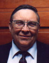

Gerald Smith Oswald
| Birth | : | 4 May 1928 Hamilton County, Nebraska, USA |
| Death | : | 24 Mar 2001 Aurora, Hamilton County, Nebraska, USA |
| Burial | : | Sunny Slope Cemetery, West Point, King William County, USA |
| Coordinate | : | 37.5477982, -76.8031006 |
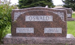
| Description | : | Gerald S. Oswald, descendant of four pioneer Hamilton County families-Smith, Oswald, Springer and Toof---was born 7 miles southwest of Aurora, to Raymond and Alice (Smith) Oswald on May 4, 1928 and died in Aurora, Nebraska on March 24, 2001, at the age of 72 years. As a young man, he was baptized into the Mennonite Church. Fifty-seven years were spent in education. Elementary education was at Hamilton County and at Denair, California. High School was at Turlock, California, and completed at Aurora from 1942-1945. With the help of a scholarship, he attended Kearney State Teacher's College from 1945-1948. Graduate... Read More |
frequently asked questions (FAQ):
-
Where is Gerald Smith Oswald's memorial?
Gerald Smith Oswald's memorial is located at: Sunny Slope Cemetery, West Point, King William County, USA.
-
When did Gerald Smith Oswald death?
Gerald Smith Oswald death on 24 Mar 2001 in Aurora, Hamilton County, Nebraska, USA
-
Where are the coordinates of the Gerald Smith Oswald's memorial?
Latitude: 37.5477982
Longitude: -76.8031006
Family Members:
Parent

Siblings
Flowers:


Nearby Cemetories:
1. Sunny Slope Cemetery
West Point, King William County, USA
Coordinate: 37.5477982, -76.8031006
2. Saint Theresas Cemetery
West Point, King William County, USA
Coordinate: 37.5466995, -76.8032990
3. Pamunkey Neck Chapel Cemetery
West Point, King William County, USA
Coordinate: 37.5300962, -76.7955810
4. Saint Luke's Baptist Church Cemetery
New Kent County, USA
Coordinate: 37.5200700, -76.8193130
5. Dixon Cemetery
Mattaponi, King and Queen County, USA
Coordinate: 37.5801570, -76.7693140
6. Ephesus Baptist Church Cemetery
West Point, King William County, USA
Coordinate: 37.5790700, -76.8454120
7. Oliver Russell Cemetery
Eltham, New Kent County, USA
Coordinate: 37.4993100, -76.8087500
8. Poroporone Baptist Church Cemetery
Shacklefords, King and Queen County, USA
Coordinate: 37.5514890, -76.7337300
9. Wahrani African-American Burial Ground
Barhamsville, New Kent County, USA
Coordinate: 37.5008230, -76.8502090
10. Warreneye Church Cemetery
Walkers, New Kent County, USA
Coordinate: 37.5001830, -76.8494500
11. Old Church United Methodist Church Cemetery
Shanghai, King and Queen County, USA
Coordinate: 37.6025320, -76.7704280
12. Olivet Baptist Church Cemetery
Shanghai, King and Queen County, USA
Coordinate: 37.6052130, -76.7752000
13. First Baptist Church Cemetery
Shacklefords, King and Queen County, USA
Coordinate: 37.5072460, -76.7377920
14. Saint John of Kanti Cemetery
Barhamsville, New Kent County, USA
Coordinate: 37.4881400, -76.8420300
15. Hrubienski Family Cemetery
Barhamsville, New Kent County, USA
Coordinate: 37.4958200, -76.8568500
16. Mount Olive Baptist Church Cemetery
Barhamsville, New Kent County, USA
Coordinate: 37.4770830, -76.7909470
17. Appleton Farm Cemetery
New Kent County, USA
Coordinate: 37.4809420, -76.8375590
18. Mount Nebo Baptist Church Cemetery
Barhamsville, New Kent County, USA
Coordinate: 37.4822070, -76.8420460
19. Eames Family Cemetery
New Kent County, USA
Coordinate: 37.5168953, -76.8864136
20. Angel View Baptist Church Cemetery
Lanexa, New Kent County, USA
Coordinate: 37.5023230, -76.8752810
21. Escobrook Baptist Church Cemetery
Mattaponi, King and Queen County, USA
Coordinate: 37.5947980, -76.7298300
22. Second Elam Baptist Church Cemetery
Lanexa, New Kent County, USA
Coordinate: 37.5225650, -76.8999570
23. Sweet Hall Cemetery
King William County, USA
Coordinate: 37.5700360, -76.9037120
24. Burton Cemetery
Mascot, King and Queen County, USA
Coordinate: 37.6084490, -76.7299050