
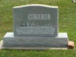
Geraldean “Gerry” Harnack Kuehl McNeal
| Birth | : | 4 Dec 1927 Clayton, Clayton County, Iowa, USA |
| Death | : | 18 Jul 2015 Strawberry Point, Clayton County, Iowa, USA |
| Burial | : | Hansel Cemetery, Mallory Township, Clayton County, USA |
| Coordinate | : | 42.7066994, -91.2433014 |
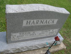
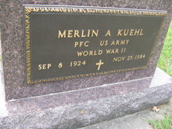
| Description | : | Geraldean “Gerry” Kuehl McNeal, 87, of Elkader, died with family by her side, Saturday, July 18, 2015, at the Strawberry Point Lutheran Home. She was born December 4, 1927, in Clayton, to LeRoy and Tillie (Koehn) Harnack. Gerry graduated from Elkader High School with the Class of 1946, and then attended Elkader Junior College for two years. Gerry was united in marriage to Merlin Arthur Kuehl on November 22, 1947. One son was born to this union. Merlin died in November of 1984. She worked as office manager for Walch Ford, Dittmer Dodge and McNeal Auto, all in Elkader. On February... Read More |
frequently asked questions (FAQ):
-
Where is Geraldean “Gerry” Harnack Kuehl McNeal's memorial?
Geraldean “Gerry” Harnack Kuehl McNeal's memorial is located at: Hansel Cemetery, Mallory Township, Clayton County, USA.
-
When did Geraldean “Gerry” Harnack Kuehl McNeal death?
Geraldean “Gerry” Harnack Kuehl McNeal death on 18 Jul 2015 in Strawberry Point, Clayton County, Iowa, USA
-
Where are the coordinates of the Geraldean “Gerry” Harnack Kuehl McNeal's memorial?
Latitude: 42.7066994
Longitude: -91.2433014
Family Members:
Parent

Spouse
Siblings

Flowers:


Nearby Cemetories:
1. Hansel Cemetery
Mallory Township, Clayton County, USA
Coordinate: 42.7066994, -91.2433014
2. Mount Harmony Cemetery
Elkport, Clayton County, USA
Coordinate: 42.7181015, -91.2799988
3. Immanuel Lutheran Cemetery
Elkport, Clayton County, USA
Coordinate: 42.7433014, -91.2733002
4. Saint Michaels Cemetery
Elkport, Clayton County, USA
Coordinate: 42.7433014, -91.2733002
5. Elk Creek Cemetery
Elk Township, Clayton County, USA
Coordinate: 42.6711006, -91.2897034
6. Old Garber Cemetery
Garber, Clayton County, USA
Coordinate: 42.7560005, -91.2580032
7. Bethel Cemetery
Osterdock, Clayton County, USA
Coordinate: 42.7041702, -91.1688919
8. Lewis Cemetery
Osterdock, Clayton County, USA
Coordinate: 42.7416000, -91.1834000
9. Asbury Cemetery
Elkport, Clayton County, USA
Coordinate: 42.7106018, -91.3202972
10. Brown Cemetery
Mallory Township, Clayton County, USA
Coordinate: 42.6530991, -91.2005997
11. Saint Paula Cemetery
Osterdock, Clayton County, USA
Coordinate: 42.7635994, -91.1992035
12. Ebenezer Cemetery
Elk Township, Clayton County, USA
Coordinate: 42.6782990, -91.3249969
13. Zion Cemetery
Colesburg, Delaware County, USA
Coordinate: 42.6380997, -91.2493973
14. Hamlett Cemetery
Elk Township, Clayton County, USA
Coordinate: 42.6581001, -91.3099976
15. Noggle Cemetery
Clayton County, USA
Coordinate: 42.6666580, -91.1654100
16. Musfeldt Cemetery
Littleport, Clayton County, USA
Coordinate: 42.7402992, -91.3339005
17. Storck Cemetery
Guttenberg, Clayton County, USA
Coordinate: 42.7694335, -91.1834638
18. Oak Hill Cemetery
Colesburg, Delaware County, USA
Coordinate: 42.6391983, -91.1924973
19. Bolsinger Cemetery
Mallory Township, Clayton County, USA
Coordinate: 42.6776340, -91.1424090
20. Eberhard Cemetery
Littleport, Clayton County, USA
Coordinate: 42.7583201, -91.3418020
21. Saint Patricks Cemetery
Colesburg, Delaware County, USA
Coordinate: 42.6241989, -91.1928024
22. Blanchaine Cemetery
Volga, Clayton County, USA
Coordinate: 42.7676210, -91.3389040
23. Graham Cemetery
Millville, Clayton County, USA
Coordinate: 42.6833172, -91.1195685
24. Krumm Cemetery
Garber, Clayton County, USA
Coordinate: 42.7913760, -91.3023559