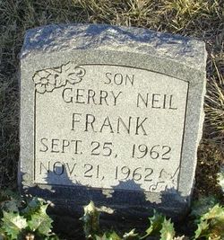
Gerry Neil Frank
| Birth | : | 25 Sep 1962 Excelsior Springs, Clay County, Missouri, USA |
| Death | : | 21 Nov 1962 Excelsior Springs, Clay County, Missouri, USA |
| Burial | : | Forest City Cemetery, South Portland, Cumberland County, USA |
| Coordinate | : | 43.6333008, -70.2799988 |
| Inscription | : | SON |
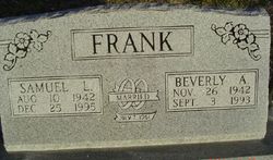
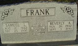
| Description | : | MO Death Cert # 62-046250 Father = Samuel Leroy Frank Mother = Beverly McCrary Informant = Samuel L. Frank COD = Gastro Malformation |
frequently asked questions (FAQ):
-
Where is Gerry Neil Frank's memorial?
Gerry Neil Frank's memorial is located at: Forest City Cemetery, South Portland, Cumberland County, USA.
-
When did Gerry Neil Frank death?
Gerry Neil Frank death on 21 Nov 1962 in Excelsior Springs, Clay County, Missouri, USA
-
Where are the coordinates of the Gerry Neil Frank's memorial?
Latitude: 43.6333008
Longitude: -70.2799988
Family Members:
Parent
Siblings
Flowers:
Nearby Cemetories:
1. Forest City Cemetery
South Portland, Cumberland County, USA
Coordinate: 43.6333008, -70.2799988
2. Brown's Hill Cemetery
South Portland, Cumberland County, USA
Coordinate: 43.6292114, -70.2839584
3. Calvary Cemetery
South Portland, Cumberland County, USA
Coordinate: 43.6323100, -70.2902700
4. Western Cemetery
Portland, Cumberland County, USA
Coordinate: 43.6450005, -70.2746964
5. Highland Memorial Gardens
South Portland, Cumberland County, USA
Coordinate: 43.6166992, -70.2799988
6. Memorial Garden at Cathedral Church of Saint Luke
Portland, Cumberland County, USA
Coordinate: 43.6523222, -70.2648576
7. Micah Dyer Plot
South Portland, Cumberland County, USA
Coordinate: 43.6196650, -70.2554380
8. Wescott Cemetery
South Portland, Cumberland County, USA
Coordinate: 43.6244389, -70.3093639
9. Bay View Cemetery
South Portland Gardens, Cumberland County, USA
Coordinate: 43.6259960, -70.2477840
10. Long Creek Cemetery
South Portland, Cumberland County, USA
Coordinate: 43.6328166, -70.3181143
11. Mount Pleasant Cemetery
South Portland, Cumberland County, USA
Coordinate: 43.6356010, -70.2403030
12. First Parish Church
Portland, Cumberland County, USA
Coordinate: 43.6583142, -70.2580524
13. Meeting House Hill
South Portland, Cumberland County, USA
Coordinate: 43.6354030, -70.2391200
14. Brooklawn Memorial Park
Portland, Cumberland County, USA
Coordinate: 43.6501274, -70.3214493
15. Stroudwater Burying Ground
Portland, Cumberland County, USA
Coordinate: 43.6582000, -70.3147100
16. Smith Street Cemetery
South Portland, Cumberland County, USA
Coordinate: 43.6414940, -70.2314440
17. Eastern Cemetery
Portland, Cumberland County, USA
Coordinate: 43.6624985, -70.2506027
18. Temple Beth El Memorial Park
Portland, Cumberland County, USA
Coordinate: 43.6503060, -70.3243020
19. Old Settlers Cemetery
South Portland, Cumberland County, USA
Coordinate: 43.6457110, -70.2274690
20. 1812 Memorial
Portland, Cumberland County, USA
Coordinate: 43.6704930, -70.2466300
21. Skillin Cemetery
South Portland, Cumberland County, USA
Coordinate: 43.6363000, -70.3451100
22. Evergreen Cemetery
Portland, Cumberland County, USA
Coordinate: 43.6800003, -70.3016968
23. Fort Scammel
Portland, Cumberland County, USA
Coordinate: 43.6492500, -70.2132800
24. Pine Grove Cemetery
Portland, Cumberland County, USA
Coordinate: 43.6836014, -70.2985992


