
Gertrude A Bibber Smith
| Birth | : | 18 Oct 1870 Harpswell, Cumberland County, Maine, USA |
| Death | : | 18 Dec 1898 Brockton, Plymouth County, Massachusetts, USA |
| Burial | : | West Harpswell Cemetery, West Harpswell, Cumberland County, USA |
| Coordinate | : | 43.7663480, -70.0124730 |
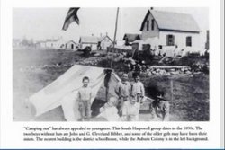
| Description | : | Buried with her brother John - her death certificate lists her burial as Union Cemetery which is incorrect. Gertrude A. Bibber married Jan, 23, 1892, William E. Smith of Manchester, Maine I think William E.was born in 1867 and I think he was the son of Mary and Elias Smith. I think his siblings were George M., and Mary O. Smith. Name: Gertrude A. Bibber Smith Event Date: 18 Dec 1898 Event Place: Brockton, Massachusetts Residence: Brockton Street Address: 79 Denton St. Gender: Female Age: 28 years 2 months Marital Status: Married Birthplace: So. Harpswell, Me Estimated Birth Year: 1870 Cause of death: General Tuberculosis Husband is listed as... Read More |
frequently asked questions (FAQ):
-
Where is Gertrude A Bibber Smith's memorial?
Gertrude A Bibber Smith's memorial is located at: West Harpswell Cemetery, West Harpswell, Cumberland County, USA.
-
When did Gertrude A Bibber Smith death?
Gertrude A Bibber Smith death on 18 Dec 1898 in Brockton, Plymouth County, Massachusetts, USA
-
Where are the coordinates of the Gertrude A Bibber Smith's memorial?
Latitude: 43.7663480
Longitude: -70.0124730
Family Members:
Parent

Siblings

Flowers:


Nearby Cemetories:
1. West Harpswell Cemetery
West Harpswell, Cumberland County, USA
Coordinate: 43.7663480, -70.0124730
2. Graveyard Point Cemetery
Harpswell Center, Cumberland County, USA
Coordinate: 43.7408560, -70.0147960
3. Orrs Island Cemetery
Orrs Island, Cumberland County, USA
Coordinate: 43.7682800, -69.9711838
4. Bailey Island Cemetery
Bailey Island, Cumberland County, USA
Coordinate: 43.7384987, -69.9942474
5. Old Harpswell Common Burying Ground
Harpswell Center, Cumberland County, USA
Coordinate: 43.7999150, -69.9876840
6. Hillcrest Cemetery
Harpswell, Cumberland County, USA
Coordinate: 43.7989200, -69.9834680
7. James Dunning Cemetery
Harpswell, Cumberland County, USA
Coordinate: 43.8222500, -69.9627800
8. Pote Cemetery
Freeport, Cumberland County, USA
Coordinate: 43.8306570, -70.0848340
9. Flying Point Cemetery
Freeport, Cumberland County, USA
Coordinate: 43.8417015, -70.0607986
10. Dunning Cemetery
Freeport, Cumberland County, USA
Coordinate: 43.8472560, -70.0398440
11. Chebeague Island Cemetery
Chebeague Island, Cumberland County, USA
Coordinate: 43.7351799, -70.1233215
12. Cliff Island Cemetery
Cliff Island, Cumberland County, USA
Coordinate: 43.6981530, -70.1052800
13. South Freeport Cemetery
South Freeport, Cumberland County, USA
Coordinate: 43.8286018, -70.1130981
14. Porters Landing Cemetery
Freeport, Cumberland County, USA
Coordinate: 43.8500250, -70.1023420
15. Bartlett Family Cemetery
Sebasco, Sagadahoc County, USA
Coordinate: 43.7874985, -69.8683014
16. Cranberry Horn Cemetery
East Harpswell, Cumberland County, USA
Coordinate: 43.8367004, -69.8989029
17. Woodlawn Cemetery
Freeport, Cumberland County, USA
Coordinate: 43.8518982, -70.1046982
18. Randall Cemetery
Freeport, Cumberland County, USA
Coordinate: 43.8432503, -70.1183777
19. Harris Cemetery
Sagadahoc County, USA
Coordinate: 43.7916985, -69.8653030
20. First Parish Cemetery
Freeport, Cumberland County, USA
Coordinate: 43.8487850, -70.1128630
21. Mast Landing Cemetery
Freeport, Cumberland County, USA
Coordinate: 43.8641400, -70.0872300
22. West Point Cemetery
Sebasco, Sagadahoc County, USA
Coordinate: 43.7542000, -69.8569031
23. Lane Cemetery
Freeport, Cumberland County, USA
Coordinate: 43.8729200, -70.0668150
24. Grove Cemetery
Freeport, Cumberland County, USA
Coordinate: 43.8742620, -70.0651360