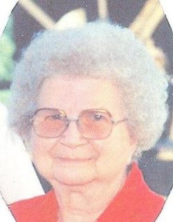
Gertrude Maxine Burk Ogden
| Birth | : | 1918 |
| Death | : | 11 Aug 2010 |
| Burial | : | Beaconsfield General Cemetery, Beaconsfield, West Tamar Council, Australia |
| Coordinate | : | -41.1848620, 146.8087650 |
| Plot | : | Sec 3 |
| Description | : | Mrs Gertrude Maxine (Burk) Ogden, of Union City, passed away at her home on August 11, 2010. She was born June 7, 1918 in Sherwood Township, Branch County, MI to Hary and Martha (Byers) Burk. She attended school at Urbandale Schools until the 5th grade then to Athens School until she graduated in 1938. She married Milo Wilfred Ogden on January 1, 1940 in Burlington by Rev. J.C. Cook. Milo was the son of Lyman Ogden and Iva (Atwood-Ogden) Smith. Maxine worked on the farm, at Cherrie Hill Restaurant near her home and drove a... Read More |
frequently asked questions (FAQ):
-
Where is Gertrude Maxine Burk Ogden's memorial?
Gertrude Maxine Burk Ogden's memorial is located at: Beaconsfield General Cemetery, Beaconsfield, West Tamar Council, Australia.
-
When did Gertrude Maxine Burk Ogden death?
Gertrude Maxine Burk Ogden death on 11 Aug 2010 in
-
Where are the coordinates of the Gertrude Maxine Burk Ogden's memorial?
Latitude: -41.1848620
Longitude: 146.8087650
Family Members:
Flowers:
Nearby Cemetories:
1. Beaconsfield General Cemetery
Beaconsfield, West Tamar Council, Australia
Coordinate: -41.1848620, 146.8087650
2. Riverlinks Anglican Church Cemetery
George Town, George Town Council, Australia
Coordinate: -41.1075360, 146.8240910
3. Auld Kirk Uniting Cemetery
Sidmouth, West Tamar Council, Australia
Coordinate: -41.2130230, 146.9058730
4. George Town General Cemetery
George Town, George Town Council, Australia
Coordinate: -41.1030870, 146.8384460
5. Winkleigh General Cemetery
Winkleigh, West Tamar Council, Australia
Coordinate: -41.2983150, 146.8543860
6. Supply River Methodist Church Cemetery
Winkleigh, West Tamar Council, Australia
Coordinate: -41.2943060, 146.8975210
7. St. Canice Catholic Cemetery
Glengarry, West Tamar Council, Australia
Coordinate: -41.3350250, 146.8701150
8. Lefroy Public Cemetery
Lefroy, George Town Council, Australia
Coordinate: -41.0989400, 146.9926300
9. Frankford Cemetery
Frankford, West Tamar Council, Australia
Coordinate: -41.3611110, 146.8022220
10. St. Matthias Churchyard
Windermere, Launceston City, Australia
Coordinate: -41.3162000, 147.0040000
11. Harford Methodist Cemetery
Harford, Latrobe Council, Australia
Coordinate: -41.2391390, 146.5463210
12. Pipers River St. Albans Anglican Cemetery
Pipers River, George Town Council, Australia
Coordinate: -41.1012446, 147.0914777
13. St. George’s Anglican Church Cemetery New Ground
Thirlstane, Latrobe Council, Australia
Coordinate: -41.2178020, 146.5069040
14. Uniting Church Cemetery
Moriarty, Latrobe Council, Australia
Coordinate: -41.2344220, 146.4977560
15. Sassafras Uniting Church Cemetery
Sassafras, Latrobe Council, Australia
Coordinate: -41.2841730, 146.5071220
16. St. James Anglican Cemetery
Northdown, Latrobe Council, Australia
Coordinate: -41.1801780, 146.4771670
17. Bangor Cemetery
Bangor, Launceston City, Australia
Coordinate: -41.2172070, 147.1384410
18. Sassafras Baptist Church Cemetery
Sassafras East, Latrobe Council, Australia
Coordinate: -41.2892740, 146.5059210
19. Turners Marsh Uniting Church Cemetery
Karoola, Launceston City, Australia
Coordinate: -41.2475306, 147.1341972
20. Wesley Vale Uniting Church New Cemetery
Wesley Vale, Latrobe Council, Australia
Coordinate: -41.1898130, 146.4635470
21. Karoola Sacred Heart Catholic Church Cemetery
Karoola, Launceston City, Australia
Coordinate: -41.2597310, 147.1431340
22. Wesley Vale Uniting Church Old Cemetery
Wesley Vale, Latrobe Council, Australia
Coordinate: -41.1906560, 146.4563100
23. Tunnel Methodist Cemetery
Tunnel, Launceston City, Australia
Coordinate: -41.1942330, 147.1820610
24. Latrobe Cemetery
Latrobe, Latrobe Council, Australia
Coordinate: -41.2378800, 146.4248200


