
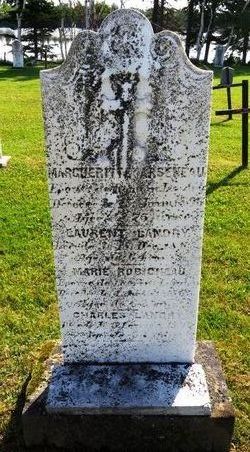
| Birth | : | 21 Jun 1830 Pokemouche, Gloucester County, New Brunswick, Canada |
| Death | : | 17 Sep 1896 Pokemouche, Gloucester County, New Brunswick, Canada |
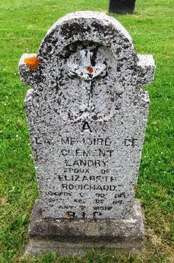
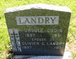
| Burial | : | Immaculate Conception Roman Catholic Cemetery, Pokemouche, Gloucester County, Canada |
| Coordinate | : | 47.6676080, -64.8751900 |
| Plot | : | St-Marc |
frequently asked questions (FAQ):
-
Where is Gervais Landry's memorial?
Gervais Landry's memorial is located at: Immaculate Conception Roman Catholic Cemetery, Pokemouche, Gloucester County, Canada.
-
When did Gervais Landry death?
Gervais Landry death on 17 Sep 1896 in Pokemouche, Gloucester County, New Brunswick, Canada
-
Where are the coordinates of the Gervais Landry's memorial?
Latitude: 47.6676080
Longitude: -64.8751900
Family Members:
Parent

Spouse

Siblings

Children
Flowers:


Nearby Cemetories:
1. Immaculate Conception Roman Catholic Cemetery
Pokemouche, Gloucester County, Canada
Coordinate: 47.6676080, -64.8751900
2. Cimetière Saint-Michel
Inkerman, Gloucester County, Canada
Coordinate: 47.6714880, -64.8206830
3. Saint Simon Roman Catholic Cemetery
Saint-Simon, Gloucester County, Canada
Coordinate: 47.7375340, -64.8413940
4. Sainte-Rose-de-Lima Cemetery
Sainte-Rose, Gloucester County, Canada
Coordinate: 47.6236430, -64.9848620
5. Sainte-Rose-de-Lima
Sainte-Rose, Gloucester County, Canada
Coordinate: 47.6237300, -64.9856000
6. Cimetière Saints-Martyrs-Canadiens
Pont-Landry, Gloucester County, Canada
Coordinate: 47.5757530, -64.9509600
7. Cimetière Marie-Médiatrice
Le Goulet, Gloucester County, Canada
Coordinate: 47.7091180, -64.6987660
8. Cimetière protestant de Caraquet
Caraquet, Gloucester County, Canada
Coordinate: 47.7926670, -64.9267930
9. Cimetière Thomas-Cooke
Caraquet, Gloucester County, Canada
Coordinate: 47.7890530, -64.9636060
10. Saint Jerome Catholic Cemetery
Shippagan, Gloucester County, Canada
Coordinate: 47.7465401, -64.7105484
11. St. Paul Roman Catholic Church Cemetery
Caraquet, Gloucester County, Canada
Coordinate: 47.8002630, -64.8295610
12. L'ancien Cimetière Paroissial Paroisse Saint-Jérôm
Shippagan, Gloucester County, Canada
Coordinate: 47.7475600, -64.7108400
13. Saint John's Cemetery
Shippagan, Gloucester County, Canada
Coordinate: 47.7431084, -64.7060347
14. Cimetière Saint-Pierre-aux-Liens
Caraquet, Gloucester County, Canada
Coordinate: 47.7897840, -64.9678210
15. Cimetière du Bocage
Caraquet, Gloucester County, Canada
Coordinate: 47.7743340, -65.0103260
16. Cimetière Saint-Augustin
Paquetville, Gloucester County, Canada
Coordinate: 47.6676590, -65.1066270
17. Cimetière des Religieuses Hospitalières
Tracadie-Sheila, Gloucester County, Canada
Coordinate: 47.5126040, -64.9081060
18. Cimetiere Saint-Jean-Baptiste-et-Saint-Joseph
Tracadie-Sheila, Gloucester County, Canada
Coordinate: 47.5129090, -64.9111320
19. Cimetière Lazaret de Tracadie
Tracadie-Sheila, Gloucester County, Canada
Coordinate: 47.5109520, -64.9052360
20. Cimetiere Saint-Jean-Baptiste-et-Saint-Joseph
Tracadie-Sheila, Gloucester County, Canada
Coordinate: 47.5121620, -64.9180760
21. Cimetière Saint-Joachim
Bertrand, Gloucester County, Canada
Coordinate: 47.7486560, -65.0778140
22. Cimetière Protestant Tracadie 1825 à 1950
Tracadie, Gloucester County, Canada
Coordinate: 47.5094560, -64.9090300
23. Cimetière des Fondateurs
Tracadie-Sheila, Gloucester County, Canada
Coordinate: 47.5084940, -64.9043870
24. Saint-Isidore Roman Catholic Cemetery
Saint-Isidore, Gloucester County, Canada
Coordinate: 47.5537330, -65.0567650