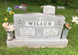
Glenda Mae Clark Wilson
| Birth | : | 26 Feb 1941 Miller County, Missouri, USA |
| Death | : | 14 Oct 2016 Tuscumbia, Miller County, Missouri, USA |
| Burial | : | Capps Cemetery, Miller County, USA |
| Coordinate | : | 38.2426300, -92.3159100 |
| Description | : | Glenda Mae (Clark) Wilson (February 26, 1941 - October 14, 2016) Glenda Mae (Clark) Wilson, was born February 26,1941 to T.A. & Millie Clark in Miller County, Missouri. She departed from this life surrounded by her children at the Miller County Nursing Home in Tuscumbia on October 14, 2016. She was married to Sherrill Wilson on June 21, 1958 at her parents’ home. He preceded her in death on January 7, 2008. Her hobbies included taking care of her many grandchildren, collecting antiques, and planting and maintaining her various flowers. Glenda was a lifelong member of Humphrey's Creek Christian Church. Survivors include... Read More |
frequently asked questions (FAQ):
-
Where is Glenda Mae Clark Wilson's memorial?
Glenda Mae Clark Wilson's memorial is located at: Capps Cemetery, Miller County, USA.
-
When did Glenda Mae Clark Wilson death?
Glenda Mae Clark Wilson death on 14 Oct 2016 in Tuscumbia, Miller County, Missouri, USA
-
Where are the coordinates of the Glenda Mae Clark Wilson's memorial?
Latitude: 38.2426300
Longitude: -92.3159100
Family Members:
Parent
Spouse
Siblings
Flowers:
Nearby Cemetories:
1. Capps Cemetery
Miller County, USA
Coordinate: 38.2426300, -92.3159100
2. King Family Cemetery
Capps, Miller County, USA
Coordinate: 38.2328400, -92.3298000
3. Saint Lawrence Catholic Cemetery
Saint Elizabeth, Miller County, USA
Coordinate: 38.2542200, -92.2708900
4. Bilyeu Cemetery
Tuscumbia, Miller County, USA
Coordinate: 38.1959114, -92.3347626
5. Davy Jones Cemetery
Cole County, USA
Coordinate: 38.2743000, -92.2606000
6. Amos Cemetery
Jefferson City, Cole County, USA
Coordinate: 38.2921000, -92.2824000
7. Old Saint Elizabeth Cemetery
Saint Elizabeth, Miller County, USA
Coordinate: 38.2952900, -92.2860600
8. Ramsey Cemetery
Miller County, USA
Coordinate: 38.1889000, -92.3641968
9. Our Lady of the Snows Cemetery
Marys Home, Miller County, USA
Coordinate: 38.3038440, -92.3567560
10. Musick Family Cemetery
Tuscumbia, Miller County, USA
Coordinate: 38.2659300, -92.4004200
11. Old Berry - McCann Cemetery
Russellville, Cole County, USA
Coordinate: 38.2759000, -92.2342000
12. Stark Cemetery
Miller County, USA
Coordinate: 38.1998200, -92.3935900
13. Jenkins-Bungart Cemetery
Marys Home, Miller County, USA
Coordinate: 38.3133011, -92.3480988
14. Wilson Cemetery
Miller County, USA
Coordinate: 38.1706009, -92.3507996
15. Rush Chapel Cemetery
Miller County, USA
Coordinate: 38.2950600, -92.3902100
16. Hopewell Cemetery
Tuscumbia, Miller County, USA
Coordinate: 38.2024800, -92.4023100
17. Barnhart Cemetery
Miller County, USA
Coordinate: 38.2338982, -92.2086029
18. Bear Cemetery
Miller County, USA
Coordinate: 38.2244070, -92.4236610
19. Saint Anthony Cemetery
Miller County, USA
Coordinate: 38.1583100, -92.2744400
20. Mount Zion Cemetery
Tuscumbia, Miller County, USA
Coordinate: 38.2083900, -92.4254600
21. Nixdorf Cemetery
Tuscumbia, Miller County, USA
Coordinate: 38.1786200, -92.4033300
22. Jarrett Cemetery
Iberia, Miller County, USA
Coordinate: 38.1475300, -92.3125300
23. Bates Burial
Saint Thomas, Cole County, USA
Coordinate: 38.2820000, -92.2016000
24. Smiths Cemetery
Tuscumbia, Miller County, USA
Coordinate: 38.2551651, -92.4403381


