
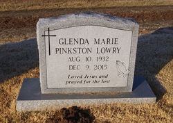
Glenda Marie Pinkston Lowry
| Birth | : | 10 Aug 1932 St. Francois County, Missouri, USA |
| Death | : | 9 Dec 2015 Huntsville, Madison County, Alabama, USA |
| Burial | : | Marvin Chapel Cemetery, Bonne Terre, St. Francois County, USA |
| Coordinate | : | 37.9299000, -90.4530000 |
| Description | : | Glenda Marie Lowry, 83, of Huntsville, passed away at her home on Wednesday, December 9, 2015. Visitation will be at First Church of the Nazarene on Monday, December 14 from 12:30 to 2:00 pm. Funeral service will be at 2:00 p.m. Burial will be in Marvin Chapel United Methodist Cemetery in Bonne Terre, Missouri on December 16. Rev. Scott K. Lowry and Rev. Levi S. Lowry will be officiating. Berryhill Funeral Home is assisting the family. courtesy of berryhillfh.com |
frequently asked questions (FAQ):
-
Where is Glenda Marie Pinkston Lowry's memorial?
Glenda Marie Pinkston Lowry's memorial is located at: Marvin Chapel Cemetery, Bonne Terre, St. Francois County, USA.
-
When did Glenda Marie Pinkston Lowry death?
Glenda Marie Pinkston Lowry death on 9 Dec 2015 in Huntsville, Madison County, Alabama, USA
-
Where are the coordinates of the Glenda Marie Pinkston Lowry's memorial?
Latitude: 37.9299000
Longitude: -90.4530000
Family Members:
Parent

Siblings
Flowers:


Nearby Cemetories:
1. Marvin Chapel Cemetery
Bonne Terre, St. Francois County, USA
Coordinate: 37.9299000, -90.4530000
2. Ashburn Cemetery
East Bonne Terre, St. Francois County, USA
Coordinate: 37.9338500, -90.4727000
3. Richardson Cemetery
Bonne Terre, St. Francois County, USA
Coordinate: 37.9525330, -90.4501500
4. Byington Cemetery
Bonne Terre, St. Francois County, USA
Coordinate: 37.9519005, -90.4456024
5. McCreary Cemetery
St. Francois County, USA
Coordinate: 37.9417000, -90.4178009
6. Cruncleton Cemetery
St. Francois County, USA
Coordinate: 37.9474983, -90.4139023
7. Mostiller Cemetery
St. Francois County, USA
Coordinate: 37.9672012, -90.4403000
8. Perret Cemetery
St. Francois County, USA
Coordinate: 37.9667015, -90.4768982
9. Aulsbury Chapel Cemetery
Bonne Terre, St. Francois County, USA
Coordinate: 37.9432983, -90.3993988
10. Cedar Falls Cemetery
Desloge, St. Francois County, USA
Coordinate: 37.8866000, -90.4743000
11. Herod Cemetery
Bonne Terre, St. Francois County, USA
Coordinate: 37.8866997, -90.4982986
12. Kerlagon Cemetery
St. Francois County, USA
Coordinate: 37.9488983, -90.3861008
13. Hill Cemetery
Bonne Terre, St. Francois County, USA
Coordinate: 37.9185104, -90.5278091
14. Saint Francois Memorial Park
Bonne Terre, St. Francois County, USA
Coordinate: 37.8931000, -90.5136000
15. Baker Cemetery
Desloge, St. Francois County, USA
Coordinate: 37.8963280, -90.5206528
16. McHenry Cemetery
Desloge, St. Francois County, USA
Coordinate: 37.8697014, -90.4850006
17. Hall Cemetery
St. Francois County, USA
Coordinate: 37.9880981, -90.4132996
18. Saint Anne Cemetery
French Village, St. Francois County, USA
Coordinate: 37.9732340, -90.3894550
19. Cunningham Cemetery
Esther, St. Francois County, USA
Coordinate: 37.8616982, -90.4672012
20. Bonne Terre Cemetery
Bonne Terre, St. Francois County, USA
Coordinate: 37.9173000, -90.5393000
21. Wheelehon Cemetery
St. Francois County, USA
Coordinate: 37.9399790, -90.5412120
22. Saint Joseph Cemetery
Bonne Terre, St. Francois County, USA
Coordinate: 37.9282990, -90.5441971
23. Highley-McHenry Cemetery
Esther, St. Francois County, USA
Coordinate: 37.8609220, -90.4842740
24. Smallpox Cemetery
St. Francois County, USA
Coordinate: 37.8891983, -90.5306015