
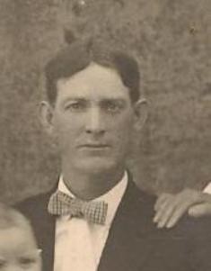


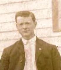
Golden Safe Brewer
| Birth | : | 28 Mar 1891 Oregon County, Missouri, USA |
| Death | : | 20 Mar 1946 Oregon County, Missouri, USA |
| Burial | : | Charters Towers Pioneer Cemetery, Charters Towers, Charters Towers Region, Australia |
| Coordinate | : | -20.0855180, 146.2695370 |
| Description | : | Known by Safe. Son of Josephus C. Brewer and Mary Jane (Sisk) Brewer. Married Bertha 'Ella' Luella Wheeler 01/Jan/1913. Farmer. Missionary Baptist faith. Per MO Death certificate #13992, burial 24/Mar/1946. Death certificate gives birth year as 1890. ~~~~~ Safe Brewer was the son of J.C. and Mary Jane Sisk Brewer. He was a prominent farmer, carpenter and school bus driver in the Myrtle and Couch area. He had four brothers, Doc, Felix, Cletus, and Eklund; and three sisters, Virginia, Temm, and Virgle. The children of Safe and Ella Wheeler were Carl, Hanford, Floyd, Irene Dail, and Earnestine Regan.... Read More |
frequently asked questions (FAQ):
-
Where is Golden Safe Brewer's memorial?
Golden Safe Brewer's memorial is located at: Charters Towers Pioneer Cemetery, Charters Towers, Charters Towers Region, Australia.
-
When did Golden Safe Brewer death?
Golden Safe Brewer death on 20 Mar 1946 in Oregon County, Missouri, USA
-
Where are the coordinates of the Golden Safe Brewer's memorial?
Latitude: -20.0855180
Longitude: 146.2695370
Family Members:
Parent
Spouse
Siblings
Children


Nearby Cemetories:
1. Charters Towers Pioneer Cemetery
Charters Towers, Charters Towers Region, Australia
Coordinate: -20.0855180, 146.2695370
2. Charters Towers Monumental & Lawn Cemetery
Charters Towers, Charters Towers Region, Australia
Coordinate: -20.0441050, 146.2456630
3. Sellheim Cemetery
Sellheim, Charters Towers Region, Australia
Coordinate: -20.0096093, 146.4013893
4. Macrossan Cemetery
Macrossan, Charters Towers Region, Australia
Coordinate: -20.0021640, 146.4439990
5. Ravenswood Cemetery
Ravenswood, Charters Towers Region, Australia
Coordinate: -20.1116040, 146.8872210
6. Manton Cemetery
Manton, Townsville City, Australia
Coordinate: -19.6511300, 146.8335700
7. Range Hotel
Townsville City, Australia
Coordinate: -19.3514510, 146.4871560
8. Stewart's Creek Penal Establishment Cemetery
Stuart, Townsville City, Australia
Coordinate: -19.3524684, 146.8498339
9. Giru-Woodstock Road Homestead Cemetery
Giru, Burdekin Shire, Australia
Coordinate: -19.5477500, 147.0598300
10. Woongarra Crematorium
Townsville, Townsville City, Australia
Coordinate: -19.3580935, 146.8756311
11. Pentland Cemetery
Pentland, Charters Towers Region, Australia
Coordinate: -20.5237240, 145.3916070
12. West End Cemetery
West End, Townsville City, Australia
Coordinate: -19.2657130, 146.8011430
13. Belgian Gardens Cemetery
Belgian Gardens, Townsville City, Australia
Coordinate: -19.2431100, 146.7826400
14. Sacred Heart Cathedral
Townsville, Townsville City, Australia
Coordinate: -19.2589000, 146.8118000
15. North Queensland Garden of Remembrance
Townsville, Townsville City, Australia
Coordinate: -19.2554030, 146.8240260
16. West Point Cemetery
Magnetic Island, Townsville City, Australia
Coordinate: -19.1334561, 146.7864305
17. Magnetic Island Memorial Gardens
Townsville, Townsville City, Australia
Coordinate: -19.1562722, 146.8551167
18. Florence Bay Scout Chapel Cemetery
Magnetic Island, Townsville City, Australia
Coordinate: -19.1239643, 146.8765564
19. St Helens Anglican Church Columbarium Wall
Home Hill, Burdekin Shire, Australia
Coordinate: -19.6572720, 147.4130880
20. Home Hill General Cemetery
Home Hill, Burdekin Shire, Australia
Coordinate: -19.6630800, 147.4259200
21. Ayr Cemetery
Ayr, Burdekin Shire, Australia
Coordinate: -19.5641000, 147.3909940
22. Cunningham Family Cemetery
Collinsville, Whitsunday Region, Australia
Coordinate: -20.4982000, 147.6299000
23. Torrens Creek Cemetery
Torrens Creek, Flinders Shire, Australia
Coordinate: -20.7641800, 145.0247870
24. Palm Island
Palm Island, Palm Island Shire, Australia
Coordinate: -18.7354000, 146.5778575