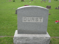
| Birth | : | 22 Dec 1899 Mason County, West Virginia, USA |
| Death | : | 16 Jul 1969 Charleston, Kanawha County, West Virginia, USA |
| Burial | : | Montague Dutch Reformed Churchyard, Montague, Sussex County, USA |
| Coordinate | : | 41.3056984, -74.7930984 |
| Description | : | NOTE from Find A Grave contributor Audrey Clendenin. According to the 1899 Register of Births for Mason County, p. 968, line 41, Goldie E. Durst was born in Mason County on December 22, 1899 to J. W. Durst and Addie. West Virginia, Deaths Index, 1853-1973 reveals that Addie's maiden name was Rollins and J. W. stands for John W. The Deaths Index reveals that Goldia Elsie Durst Ankrum died on July 16, 1969 in Kanawha County, West Virginia at the age of 69 years 6 months 24 days. Her spouse was Sidney Elroy "Roy" Ankrum and his years... Read More |
frequently asked questions (FAQ):
-
Where is Goldia Elsie Durst Ankrum's memorial?
Goldia Elsie Durst Ankrum's memorial is located at: Montague Dutch Reformed Churchyard, Montague, Sussex County, USA.
-
When did Goldia Elsie Durst Ankrum death?
Goldia Elsie Durst Ankrum death on 16 Jul 1969 in Charleston, Kanawha County, West Virginia, USA
-
Where are the coordinates of the Goldia Elsie Durst Ankrum's memorial?
Latitude: 41.3056984
Longitude: -74.7930984
Family Members:
Parent
Spouse
Siblings
Flowers:
Nearby Cemetories:
1. Montague Dutch Reformed Churchyard
Montague, Sussex County, USA
Coordinate: 41.3056984, -74.7930984
2. Milford Cemetery
Milford, Pike County, USA
Coordinate: 41.3143997, -74.8031006
3. Kurtz Farm Cemetery
Milford, Pike County, USA
Coordinate: 41.3007000, -74.8212000
4. Tom Quick Monument
Milford, Pike County, USA
Coordinate: 41.3271400, -74.7979230
5. Old Dimmick Cemetery
Pike County, USA
Coordinate: 41.3263340, -74.8076720
6. Cliff Park Road Cemetery
Milford, Pike County, USA
Coordinate: 41.3120500, -74.8287800
7. Laurel Hill Cemetery
Milford, Pike County, USA
Coordinate: 41.3300000, -74.8187000
8. Quicktown Cemetery
Westfall Township, Pike County, USA
Coordinate: 41.3404980, -74.7671760
9. Hainesville Cemetery
Hainesville, Sussex County, USA
Coordinate: 41.2557983, -74.7944031
10. Travis Cemetery
Milford, Pike County, USA
Coordinate: 41.3333015, -74.8681030
11. Rosetown Cemetery
Matamoras, Pike County, USA
Coordinate: 41.3551300, -74.7080900
12. Pine Grove Cemetery
Matamoras, Pike County, USA
Coordinate: 41.3556099, -74.7072983
13. Mettler Cemetery
Sandyston Township, Sussex County, USA
Coordinate: 41.2326776, -74.8506294
14. Old Frenchtown Cemetery
Pike County, USA
Coordinate: 41.3280510, -74.9034410
15. Cemetery on Bell Farm
Matamoras, Pike County, USA
Coordinate: 41.3619490, -74.7008840
16. Layton Cemetery
Layton, Sussex County, USA
Coordinate: 41.2175789, -74.8220673
17. Laurel Grove Cemetery
Port Jervis, Orange County, USA
Coordinate: 41.3600006, -74.6893997
18. Delaware Cemetery
Dingmans Ferry, Pike County, USA
Coordinate: 41.2268982, -74.8705978
19. Magagkamack Churchyard
Port Jervis, Orange County, USA
Coordinate: 41.3647881, -74.6839294
20. Saint Marys Cemetery
Port Jervis, Orange County, USA
Coordinate: 41.3652992, -74.6813965
21. Brink-Colesville Cemetery
Colesville, Sussex County, USA
Coordinate: 41.2709618, -74.6592102
22. Saint Johns Cemetery (Defunct)
Port Jervis, Orange County, USA
Coordinate: 41.3772070, -74.6870030
23. Deerpark Reformed Churchyard
Port Jervis, Orange County, USA
Coordinate: 41.3774320, -74.6861870
24. Sparrowbush Pine Hill Cemetery
Sparrow Bush, Orange County, USA
Coordinate: 41.4060100, -74.7296910


