Goldie Mae Racus Holland
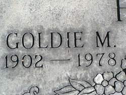
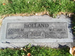
| Birth | : | 11 Mar 1902 Kansas, USA |
| Death | : | 26 May 1978 Wenatchee, Chelan County, Washington, USA |
| Burial | : | Anthony Community Cemetery, Anthony, Doña Ana County, USA |
| Coordinate | : | 32.0095000, -106.6025000 |
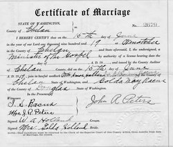
| Description | : | m: 15 Jun 1919 in Chelan Co, WA |
frequently asked questions (FAQ):
-
Where is Goldie Mae Racus Holland's memorial?
Goldie Mae Racus Holland's memorial is located at: Anthony Community Cemetery, Anthony, Doña Ana County, USA.
-
When did Goldie Mae Racus Holland death?
Goldie Mae Racus Holland death on 26 May 1978 in Wenatchee, Chelan County, Washington, USA
-
Where are the coordinates of the Goldie Mae Racus Holland's memorial?
Latitude: 32.0095000
Longitude: -106.6025000
Family Members:
Parent
Spouse
Siblings
Children
Flowers:
Nearby Cemetories:
1. Anthony Community Cemetery
Anthony, Doña Ana County, USA
Coordinate: 32.0095000, -106.6025000
2. Anthony Catholic Cemetery
Anthony, Doña Ana County, USA
Coordinate: 32.0102000, -106.5996000
3. Saint Anthony's Catholic Cemetery
Anthony, Doña Ana County, USA
Coordinate: 32.0027290, -106.6023290
4. Story Cemetery
Anthony, Doña Ana County, USA
Coordinate: 32.0025770, -106.6029420
5. Saint Anthony's Columbarium
Anthony, Doña Ana County, USA
Coordinate: 32.0016900, -106.6037700
6. Berino Cemetery
Berino, Doña Ana County, USA
Coordinate: 32.0686750, -106.6159270
7. Old Berino Cemetery
Doña Ana County, USA
Coordinate: 32.0708008, -106.6207962
8. Chamberino Cemetery
Chamberino, Doña Ana County, USA
Coordinate: 32.0334000, -106.6870000
9. La Union Cemetery
La Union, Doña Ana County, USA
Coordinate: 31.9483500, -106.6640660
10. Canutillo Cemetery
El Paso County, USA
Coordinate: 31.9167614, -106.5948029
11. Saint Luke's Episcopal Church Columbarium
La Union, Doña Ana County, USA
Coordinate: 31.9190930, -106.6319730
12. Vado Riverview Cemetery
Vado, Doña Ana County, USA
Coordinate: 32.1185000, -106.6373000
13. San Jose Cemetery
La Mesa, Doña Ana County, USA
Coordinate: 32.1154400, -106.7048200
14. Tompkins Family Cemetery
Chaparral, Doña Ana County, USA
Coordinate: 32.0159760, -106.4282670
15. Memory Gardens of the Valley
Santa Teresa, Doña Ana County, USA
Coordinate: 31.8387080, -106.6191660
16. Saint Francis on the Hill Episcopal Church Columba
El Paso, El Paso County, USA
Coordinate: 31.8429910, -106.5307440
17. Desert View Cemetery
Chaparral, Doña Ana County, USA
Coordinate: 32.0400490, -106.3949600
18. San Miguel Cemetery
San Miguel, Doña Ana County, USA
Coordinate: 32.1622440, -106.7278000
19. Memorial Pines Cemetery
Sunland Park, Doña Ana County, USA
Coordinate: 31.8207000, -106.6058500
20. Missionary Ridge Cemetery
Mesquite, Doña Ana County, USA
Coordinate: 32.1858020, -106.6857560
21. Restlawn Memorial Park
El Paso, El Paso County, USA
Coordinate: 31.8626790, -106.4325110
22. McGill County Cemetery
El Paso, El Paso County, USA
Coordinate: 31.8574333, -106.4262543
23. Smeltertown Cemetery
El Paso County, USA
Coordinate: 31.7869950, -106.5214060
24. Fort Bliss National Cemetery
El Paso, El Paso County, USA
Coordinate: 31.8236008, -106.4222031

