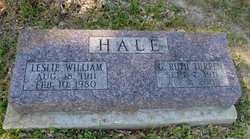
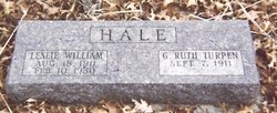
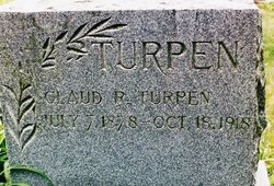
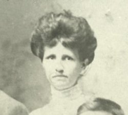
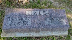
Grace Ruth Turpen Hale
| Birth | : | 7 Sep 1911 Pleasanton, Decatur County, Iowa, USA |
| Death | : | 4 Apr 2009 Decatur County, Iowa, USA |
| Burial | : | Mellösa Kyrkogård, Mellosa, Flens kommun, Sweden |
| Coordinate | : | 59.1000073, 16.5500845 |
| Description | : | Grace "Ruth" lived most of her life in Council Bluffs, Iowa. She was a member of The Community of Christ Church, formerly Reorganized Church of Jesus Christ of Later Day Saints. She and her sister-in-law Thelma Turpin were involved in the women's service groups. Ruth was a organist for her church as well as other churches. She was a very accomplished musician and in her spare time taught piano to many students. Ruth and her husband, Leslie were parents to son Leslie Jr. Contributor: Dixie P (48916457) |
frequently asked questions (FAQ):
-
Where is Grace Ruth Turpen Hale's memorial?
Grace Ruth Turpen Hale's memorial is located at: Mellösa Kyrkogård, Mellosa, Flens kommun, Sweden.
-
When did Grace Ruth Turpen Hale death?
Grace Ruth Turpen Hale death on 4 Apr 2009 in Decatur County, Iowa, USA
-
Where are the coordinates of the Grace Ruth Turpen Hale's memorial?
Latitude: 59.1000073
Longitude: 16.5500845
Family Members:
Parent
Spouse
Siblings
Flowers:
Nearby Cemetories:
1. Mellösa Kyrkogård
Mellosa, Flens kommun, Sweden
Coordinate: 59.1000073, 16.5500845
2. Mellösa Församling Kvarter 3
Halleforsnas, Flens kommun, Sweden
Coordinate: 59.1518570, 16.4938092
3. Lilla Malma gamla kyrkogård
Malmkoping, Flens kommun, Sweden
Coordinate: 59.1349594, 16.7263983
4. Vadsbro Kyrka
Vadsbro, Flens kommun, Sweden
Coordinate: 58.9773068, 16.5663294
5. Dunker Church Cemetery
Dunker, Flens kommun, Sweden
Coordinate: 59.1663160, 16.7819595
6. Blacksta Church Cemetery
Blacksta, Gnesta kommun, Sweden
Coordinate: 58.9582100, 16.6340809
7. Ådala Kyrkogård
Bettna, Flens kommun, Sweden
Coordinate: 58.9939522, 16.8291178
8. Skogskyrkogården
Katrineholms kommun, Sweden
Coordinate: 58.9816400, 16.2290490
9. Katrineholm Kyrkogård
Katrineholm, Katrineholms kommun, Sweden
Coordinate: 58.9919670, 16.1948670
10. Husby-Rekarne kyrkogård
Eskilstuna kommun, Sweden
Coordinate: 59.3142240, 16.4520100
11. Husby-Oppunda kyrkogård
Vrena, Nyköpings kommun, Sweden
Coordinate: 58.9087626, 16.8041195
12. Halla kyrkogård
Vrena, Nyköpings kommun, Sweden
Coordinate: 58.8593901, 16.6252792
13. Julita gård
Strängnäs kommun, Sweden
Coordinate: 59.1483600, 16.0449400
14. Öja kyrka
Öja, Eskilstuna kommun, Sweden
Coordinate: 59.2865367, 16.1595214
15. Länna kyrkogård
Strängnäs, Strängnäs kommun, Sweden
Coordinate: 59.2814570, 16.9839330
16. Mikaelikyrkan
Västerås, Västerås kommun, Sweden
Coordinate: 59.3619490, 16.3149200
17. Kjula Kyrka
Eskilstuna, Eskilstuna kommun, Sweden
Coordinate: 59.3970139, 16.6746663
18. Hammarby Kyrka
Hammarby, Eskilstuna kommun, Sweden
Coordinate: 59.4059215, 16.5946144
19. Västermo kyrkogård
Eskilstuna kommun, Sweden
Coordinate: 59.2910527, 16.0797507
20. Jäders kyrka
Eskilstuna, Eskilstuna kommun, Sweden
Coordinate: 59.4096640, 16.6910280
21. Vallby Kyrka
Vallby, Eskilstuna kommun, Sweden
Coordinate: 59.4217961, 16.5652439
22. Sundby kyrka
Eskilstuna kommun, Sweden
Coordinate: 59.4337788, 16.6338627
23. Vingaker Kyrkogård
Vingaker, Vingåkers kommun, Sweden
Coordinate: 59.0531448, 15.8784793
24. Strängnäs södra kyrkogård
Strängnäs, Strängnäs kommun, Sweden
Coordinate: 59.3556780, 17.0148080

