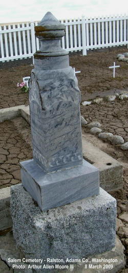
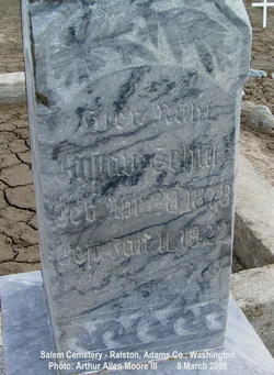
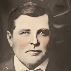
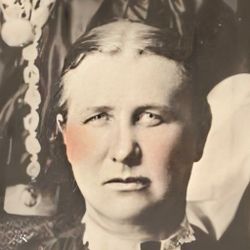
Gustave “George” Schutz
| Birth | : | 28 Apr 1878 |
| Death | : | 11 Jan 1922 Paha, Adams County, Washington, USA |
| Burial | : | Loxton Cemetery, Loxton, District Council of Loxton Waikerie, Australia |
| Coordinate | : | -34.4556160, 140.5714420 |
| Description | : | Born: Kulm, Bessarabia, South Russia (German speaking Russia) Age at Death: 43yr 8mo 13da Married 6 DEC 1901 to Emilia Teschner Schutz Children 1. Theodore Schutz 2. Alexander Schutz 3. Elsie Schutz 4. Raymond Schutz 5. Gertruce Erma Schutz ____________________ Farmer Shot Near Paha George Schutz, a farmer living near Paha, was fatally wounded yesterday afternoon by the accidental discharge of a shotgun during a rabbit drive held in the Paha country. He died about six o'clock through profuse bleeding. The drive was over and the men were standing around, according to the report received here, Schutz happened to swing his gun around it struck the gun of... Read More |
frequently asked questions (FAQ):
-
Where is Gustave “George” Schutz's memorial?
Gustave “George” Schutz's memorial is located at: Loxton Cemetery, Loxton, District Council of Loxton Waikerie, Australia.
-
When did Gustave “George” Schutz death?
Gustave “George” Schutz death on 11 Jan 1922 in Paha, Adams County, Washington, USA
-
Where are the coordinates of the Gustave “George” Schutz's memorial?
Latitude: -34.4556160
Longitude: 140.5714420
Family Members:
Parent
Spouse
Siblings
Children
Flowers:
Nearby Cemetories:
1. Loxton North Cemetery
Loxton, District Council of Loxton Waikerie, Australia
Coordinate: -34.3939900, 140.6017800
2. Bookpurnong Pilgrims of Zion Lutheran Cemetery
Berri, Berri Barmera Council, Australia
Coordinate: -34.3281160, 140.6062620
3. New Residence Trinity Lutheran Church Cemetery
Moorook, District Council of Loxton Waikerie, Australia
Coordinate: -34.3726190, 140.4054430
4. Berri General Cemetery
Berri, Berri Barmera Council, Australia
Coordinate: -34.2764387, 140.5888914
5. Bugle Hut Lutheran Cemetery
Loxton, District Council of Loxton Waikerie, Australia
Coordinate: -34.3607730, 140.7801570
6. Myrla Lutheran Cemetery
Wunkar, District Council of Loxton Waikerie, Australia
Coordinate: -34.4513750, 140.3225740
7. Barmera Cemetery
Barmera, Berri Barmera Council, Australia
Coordinate: -34.2642300, 140.4435640
8. Moorook Cemetery
Moorook, District Council of Loxton Waikerie, Australia
Coordinate: -34.2919660, 140.3523210
9. Alawoona Cemetery
Alawoona, District Council of Loxton Waikerie, Australia
Coordinate: -34.7335890, 140.5090860
10. Kingston on Murray
Kingston, District Council of Loxton Waikerie, Australia
Coordinate: -34.2330100, 140.3493100
11. Paruna Cemetery
District Council of Loxton Waikerie, Australia
Coordinate: -34.7251500, 140.7405500
12. Renmark Cemetery
Renmark, Renmark Paringa Council, Australia
Coordinate: -34.1723650, 140.7225840
13. Stoeckel Family Cemetery
Paringa, Renmark Paringa Council, Australia
Coordinate: -34.1785780, 140.7803160
14. Paringa Cemetery
Paringa, Renmark Paringa Council, Australia
Coordinate: -34.1628170, 140.7821640
15. Meribah Cemetery
Meribah, District Council of Loxton Waikerie, Australia
Coordinate: -34.7060680, 140.8637590
16. Overland Corner Cemetery
Barmera, Berri Barmera Council, Australia
Coordinate: -34.1475900, 140.3426400
17. Wanbi Cemetery
Wanbi, District Council of Karoonda East Murray, Australia
Coordinate: -34.7634610, 140.2968910
18. Taplan Saint John Lutheran Cemetery
Taplan, District Council of Loxton Waikerie, Australia
Coordinate: -34.5455690, 140.0000000
19. Saint Paul's Lutheran Churchyard
Lowbank, District Council of Loxton Waikerie, Australia
Coordinate: -34.1906660, 140.0813100
20. Galga Cemetery
Waikerie, District Council of Loxton Waikerie, Australia
Coordinate: -34.6889690, 140.0567010
21. Sandalwood Cemetery
Karoonda, District Council of Karoonda East Murray, Australia
Coordinate: -34.9348120, 140.1251510
22. Meringur Cemetery
Mildura, Mildura Rural City, Australia
Coordinate: -34.3714000, 141.3343000
23. Bakara Cemetery
Bakara, District Council of Karoonda East Murray, Australia
Coordinate: -34.6538500, 139.7838500
24. Borrika Cemetery
Borrika, District Council of Karoonda East Murray, Australia
Coordinate: -35.0288060, 140.0479410


