
Hannah A. Sanders Allen
| Birth | : | 7 Feb 1825 Wilmot, Merrimack County, New Hampshire, USA |
| Death | : | 6 Jan 1847 Wallingford, Rutland County, Vermont, USA |
| Burial | : | Dickens Cemetery, Chestnut Mound, Smith County, USA |
| Coordinate | : | 36.2372017, -85.8443985 |
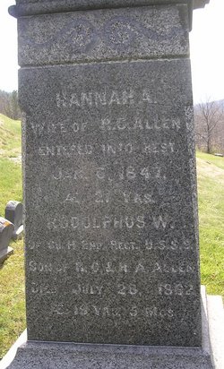
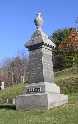
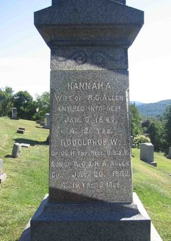
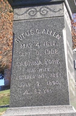
| Description | : | Dea. Rufus Cady Allen, b. May 4, 1817; m. Aug. 15, 1841, Adeline Hannah Sanders, b. in Wilmot, N. H., Feb. 7, 1825, dau. of Rev. John and Hannah (Barron) Sanders. She d. in Wallingford, Vt., Jan. 6, 1847. Children born in Wallingford, Vt.: -Rodolphus Warrington, b. Feb. 26, 1843. -Adelaide Hannah, b. Oct. 9, 1844; m. Dec. 24, 1871, Perkins M. Brown, b. Nov. 1, 1844, son of Archibald and Lydia M. Brown of Boscawen, N.H. (from "The Allen Memorial, First Series: Descendants of Edward Allen of Nantucket, Mass. 1690-1905" by Orrin Peer Allen; pub. by C.B. Fiske & Co.,... Read More |
frequently asked questions (FAQ):
-
Where is Hannah A. Sanders Allen's memorial?
Hannah A. Sanders Allen's memorial is located at: Dickens Cemetery, Chestnut Mound, Smith County, USA.
-
When did Hannah A. Sanders Allen death?
Hannah A. Sanders Allen death on 6 Jan 1847 in Wallingford, Rutland County, Vermont, USA
-
Where are the coordinates of the Hannah A. Sanders Allen's memorial?
Latitude: 36.2372017
Longitude: -85.8443985
Family Members:
Spouse
Children
Flowers:


Nearby Cemetories:
1. Dickens Cemetery
Chestnut Mound, Smith County, USA
Coordinate: 36.2372017, -85.8443985
2. Anderson Cemetery
Chestnut Mound, Smith County, USA
Coordinate: 36.2363400, -85.8391700
3. Apple-McDonald Cemetery
Chestnut Mound, Smith County, USA
Coordinate: 36.2266900, -85.8413000
4. Overstreet Cemetery #859
Elmwood, Smith County, USA
Coordinate: 36.2330580, -85.8607510
5. Overstreet Cemetery #858
Elmwood, Smith County, USA
Coordinate: 36.2334560, -85.8622960
6. Grisham Cemetery
Elmwood, Smith County, USA
Coordinate: 36.2416080, -85.8645270
7. McDonald Cemetery
Chestnut Mound, Smith County, USA
Coordinate: 36.2332360, -85.8230760
8. Harville Cemetery
Smith County, USA
Coordinate: 36.2512400, -85.8581100
9. McKinney Cemetery
Chestnut Mound, Smith County, USA
Coordinate: 36.2523045, -85.8563200
10. Ferrell Cemetery
Elmwood, Smith County, USA
Coordinate: 36.2231530, -85.8587870
11. Woodard Cemetery
Elmwood, Smith County, USA
Coordinate: 36.2342700, -85.8681300
12. Bush Cemetery
Elmwood, Smith County, USA
Coordinate: 36.2541630, -85.8310640
13. Dr. Eli P. Hawthorne Cemetery
Chestnut Mound, Smith County, USA
Coordinate: 36.2573200, -85.8406800
14. McKinney Cemetery
Chestnut Mound, Smith County, USA
Coordinate: 36.2166800, -85.8378000
15. Glover Cemetery
Chestnut Mound, Smith County, USA
Coordinate: 36.2196870, -85.8278670
16. Draper Cemetery
Chestnut Mound, Smith County, USA
Coordinate: 36.2219610, -85.8237250
17. Conditt Cemetery
Elmwood, Smith County, USA
Coordinate: 36.2347300, -85.8748300
18. High Cemetery
Chestnut Mound, Smith County, USA
Coordinate: 36.2097800, -85.8452900
19. Vaden Cemetery
Chestnut Mound, Smith County, USA
Coordinate: 36.2096020, -85.8484130
20. Hawthorne Cemetery
Chestnut Mound, Smith County, USA
Coordinate: 36.2651900, -85.8413600
21. Ford Cemetery
Elmwood, Smith County, USA
Coordinate: 36.2171200, -85.8688400
22. Ford Cemetery
Elmwood, Smith County, USA
Coordinate: 36.2189800, -85.8710900
23. Boze Cemetery
Smith County, USA
Coordinate: 36.2106190, -85.8580630
24. Dickens Cemetery
Elmwood, Smith County, USA
Coordinate: 36.2576150, -85.8706430