

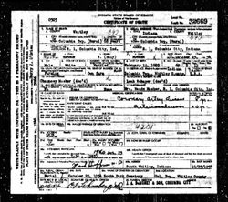
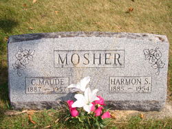
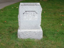
Harmon S Mosher
| Birth | : | 12 Feb 1885 Columbia Township, Whitley County, Indiana, USA |
| Death | : | 25 Oct 1954 Columbia City, Whitley County, Indiana, USA |
| Burial | : | San Marcos Cemetery, San Marcos, San Diego County, USA |
| Coordinate | : | 33.1598280, -117.1502850 |
| Plot | : | Section 3, Row 6, Grave 3/2 |
| Description | : | Mosher, Harmon Columbia City Post - Whitley County, Indiana Saturday October 23, 1954 Harmon Mosher, well known Columbia township farmer, died this morning at 7:30 at his home. Mr. Mosher had been ill since 1931 of a chronic heart ailment which had forced his partial retirement. His death occurred on the farm three miles west on the Old Yellowstone Trail where he had resided all of his life with the exception of 1906-1907 when he resided at Mulvane, Kansas where he owned and operated a feed mill. It was then that he lost a leg in a mill accident. |
frequently asked questions (FAQ):
-
Where is Harmon S Mosher's memorial?
Harmon S Mosher's memorial is located at: San Marcos Cemetery, San Marcos, San Diego County, USA.
-
When did Harmon S Mosher death?
Harmon S Mosher death on 25 Oct 1954 in Columbia City, Whitley County, Indiana, USA
-
Where are the coordinates of the Harmon S Mosher's memorial?
Latitude: 33.1598280
Longitude: -117.1502850
Family Members:
Parent
Spouse
Siblings
Flowers:


Nearby Cemetories:
1. San Marcos Cemetery
San Marcos, San Diego County, USA
Coordinate: 33.1598280, -117.1502850
2. Grace Episcopal Church Cemetery
San Marcos, San Diego County, USA
Coordinate: 33.1433296, -117.1652832
3. San Marcos Lutheran Church Columbarium
San Marcos, San Diego County, USA
Coordinate: 33.1479360, -117.2067170
4. First United Methodist Church Columbarium
Escondido, San Diego County, USA
Coordinate: 33.1197710, -117.0786030
5. Trinity Episcopal Church Columbarium
Escondido, San Diego County, USA
Coordinate: 33.1186300, -117.0699000
6. Meadowlark Pioneer Memorial Cemetery
San Marcos, San Diego County, USA
Coordinate: 33.1100998, -117.2253036
7. Meadowlark Community Church Columbarium
San Marcos, San Diego County, USA
Coordinate: 33.1122030, -117.2273590
8. Community Lutheran Church Columbarium
Escondido, San Diego County, USA
Coordinate: 33.1597140, -117.0295190
9. Oak Hill Memorial Park
Escondido, San Diego County, USA
Coordinate: 33.1292000, -117.0271988
10. Valley Center Cemetery
Valley Center, San Diego County, USA
Coordinate: 33.2388992, -117.0317001
11. San Diego Zoo Safari Park
Escondido, San Diego County, USA
Coordinate: 33.0944900, -117.0024200
12. Olivenhain Cemetery
Encinitas, San Diego County, USA
Coordinate: 33.0325510, -117.2420400
13. Eternal Hills Memorial Park
Oceanside, San Diego County, USA
Coordinate: 33.1927850, -117.3289340
14. San Luis Rey Pioneer Cemetery
Oceanside, San Diego County, USA
Coordinate: 33.2285995, -117.3193970
15. San Pasqual Indian Cemetery
San Pasqual, San Diego County, USA
Coordinate: 33.0923996, -116.9798965
16. Rancho Bernardo Presbyterian Church Columbarium
Rancho Bernardo, San Diego County, USA
Coordinate: 33.0204391, -117.0612717
17. Valley Creek Farm Burial Site
Valley Center, San Diego County, USA
Coordinate: 33.2684790, -117.0123020
18. Mission San Luis Rey Cemetery
Oceanside, San Diego County, USA
Coordinate: 33.2322800, -117.3191500
19. All Saints Cemetery
San Luis Rey, San Diego County, USA
Coordinate: 33.2340012, -117.3214035
20. Rancho Coastal Humane Society
Encinitas, San Diego County, USA
Coordinate: 33.0413980, -117.2841380
21. Incarnation Lutheran Church Columbarium
Poway, San Diego County, USA
Coordinate: 33.0194200, -117.0510600
22. Church of The Nativity Columbarium
Rancho Santa Fe, San Diego County, USA
Coordinate: 32.9971120, -117.1978040
23. Buena Vista Cemetery
Oceanside, San Diego County, USA
Coordinate: 33.1758995, -117.3511963
24. King of Kings Lutheran Church Columbarium
Oceanside, San Diego County, USA
Coordinate: 33.1997500, -117.3482260