
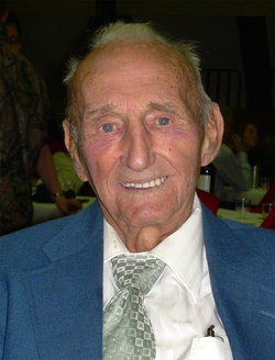


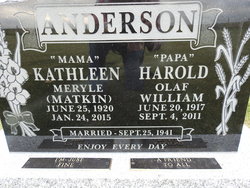

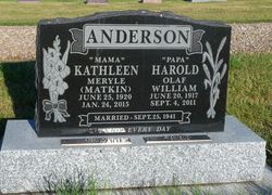
Harold Olaf William Anderson
| Birth | : | 20 Jun 1917 Lethbridge, Lethbridge Census Division, Alberta, Canada |
| Death | : | 4 Sep 2011 Milk River, Lethbridge Census Division, Alberta, Canada |
| Burial | : | Milk River Cemetery, Milk River, Lethbridge Census Division, Canada |
| Coordinate | : | 49.1442000, -112.0658700 |
| Description | : | HAROLD OLAF WILLIAM ANDERSON "…be a friend to man" June 20, 1917 – Sept 4, 2011 With tender hearts we announce the peaceful passing of our beloved husband, father, grandfather, great grandfather, and brother, Harold W. Anderson, on Sunday, Sept 4, in Milk River. Surrounded by family, "Papa" returned to Heaven. He is lovingly remembered by his wife of nearly 70 years, Kathleen Anderson; his daughter, Wendy (Ken) Brown; his 8 grandchildren: Lori Brown, Aaron (Christine) Brown, Traci (Joshua) Sherwood, Michael Brown, Kathleen Brown, Peter (Kelly) Brown, Chantelle Brown, Nola (James) Haynes and his 3 great grandchildren: Taylor, Nathan and Andrew Sherwood; his sister,... Read More |
frequently asked questions (FAQ):
-
Where is Harold Olaf William Anderson's memorial?
Harold Olaf William Anderson's memorial is located at: Milk River Cemetery, Milk River, Lethbridge Census Division, Canada.
-
When did Harold Olaf William Anderson death?
Harold Olaf William Anderson death on 4 Sep 2011 in Milk River, Lethbridge Census Division, Alberta, Canada
-
Where are the coordinates of the Harold Olaf William Anderson's memorial?
Latitude: 49.1442000
Longitude: -112.0658700
Family Members:
Parent

Spouse
Siblings


Nearby Cemetories:
1. Milk River Cemetery
Milk River, Lethbridge Census Division, Canada
Coordinate: 49.1442000, -112.0658700
2. Sweet Grass Cemetery
Sweet Grass, Toole County, USA
Coordinate: 48.9972120, -111.9966140
3. Holy Angels Cemetery Community
Coutts, Lethbridge Census Division, Canada
Coordinate: 48.9989440, -111.9649050
4. Coutts Cemetery
Coutts, Lethbridge Census Division, Canada
Coordinate: 48.9989690, -111.9647810
5. Hillside Hutterite Colony Cemetery
Toole County, USA
Coordinate: 48.9788000, -112.0740000
6. Warner Memorial Cemetery
Warner, Lethbridge Census Division, Canada
Coordinate: 49.2914900, -112.2246800
7. Allerston Cemetery
Milk River, Lethbridge Census Division, Canada
Coordinate: 49.1451500, -111.7664000
8. Rimrock Colony Cemetery
Toole County, USA
Coordinate: 48.8985000, -112.0980000
9. Masinasin Cemetery
Milk River, Lethbridge Census Division, Canada
Coordinate: 49.1302328, -111.6527199
10. Sunburst Cemetery
Sunburst, Toole County, USA
Coordinate: 48.8847800, -111.8743800
11. Glacier Colony Cemetery
Glacier Colony, Glacier County, USA
Coordinate: 48.8313000, -112.2154000
12. Zenith Colony Cemetery
Cut Bank, Glacier County, USA
Coordinate: 48.8678000, -112.3442000
13. Nutter Ranch Cemetery
Sunburst, Toole County, USA
Coordinate: 48.9668200, -111.6365320
14. New Dayton Community Cemetery
New Dayton, Lethbridge Census Division, Canada
Coordinate: 49.4254300, -112.3601800
15. Prairie Round Cemetery
Lucky Strike, Lethbridge Census Division, Canada
Coordinate: 49.2249600, -111.5523800
16. Wrentham Cemetery
Wrentham, Lethbridge Census Division, Canada
Coordinate: 49.5231200, -112.1574800
17. Prairie Home Hutterite Colony Cemetery
Wrentham, Lethbridge Census Division, Canada
Coordinate: 49.5291670, -111.9608330
18. Dahlen Family Homestead Cemetery
Kevin, Toole County, USA
Coordinate: 48.7504200, -112.1016200
19. Wolf Creek Hutterite Colony Cemetery
Stirling, Lethbridge Census Division, Canada
Coordinate: 49.4119142, -112.5163705
20. East Raymond Hutterite Colony Cemetery
Raymond, Lethbridge Census Division, Canada
Coordinate: 49.4185305, -112.5791329
21. Glendale Colony Cemetery
Glendale Colony, Glacier County, USA
Coordinate: 48.8380000, -112.5457000
22. Horizon Colony Cemetery
Cut Bank, Glacier County, USA
Coordinate: 48.7156000, -112.2290000
23. Stirling Mennonite Church Cemetery
Stirling, Lethbridge Census Division, Canada
Coordinate: 49.4607570, -112.5387970
24. Stirling Cemetery
Stirling, Lethbridge Census Division, Canada
Coordinate: 49.5093400, -112.5380000