
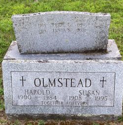
Harold Olmstead
| Birth | : | 13 Aug 1900 Stamford, Fairfield County, Connecticut, USA |
| Death | : | 3 Nov 1984 Woodsville, Grafton County, New Hampshire, USA |
| Burial | : | Pine Grove Cemetery, Woodsville, Grafton County, USA |
| Coordinate | : | 44.1380997, -72.0188980 |
| Description | : | My Grand Uncle on my mother's side. Married Susanna Avery in 1924 according to her son, Charles and had four children: Calista Jean Olmstead (1927-2008) Harold Olmstead Jr. (1930-2011) Charles Eugene Olmstead II (1933-still living) Nelson Howard Olmstead (1945-2009) |
frequently asked questions (FAQ):
-
Where is Harold Olmstead's memorial?
Harold Olmstead's memorial is located at: Pine Grove Cemetery, Woodsville, Grafton County, USA.
-
When did Harold Olmstead death?
Harold Olmstead death on 3 Nov 1984 in Woodsville, Grafton County, New Hampshire, USA
-
Where are the coordinates of the Harold Olmstead's memorial?
Latitude: 44.1380997
Longitude: -72.0188980
Family Members:
Parent

Spouse

Children
Flowers:


Nearby Cemetories:
1. Pine Grove Cemetery
Woodsville, Grafton County, USA
Coordinate: 44.1380997, -72.0188980
2. Wells River Cemetery
Wells River, Orange County, USA
Coordinate: 44.1535988, -72.0547028
3. Horse Meadow Cemetery
North Haverhill, Grafton County, USA
Coordinate: 44.1068880, -72.0405500
4. Horse Meadow Annex Cemetery
North Haverhill, Grafton County, USA
Coordinate: 44.1056820, -72.0408260
5. Carbee Cemetery
Bath, Grafton County, USA
Coordinate: 44.1724640, -72.0466980
6. West Bath Cemetery
Bath, Grafton County, USA
Coordinate: 44.1750930, -71.9865080
7. Swiftwater Cemetery
Bath, Grafton County, USA
Coordinate: 44.1303400, -71.9574300
8. Saint Joseph Cemetery
Bath, Grafton County, USA
Coordinate: 44.1803017, -72.0524979
9. Bath Village Cemetery
Bath, Grafton County, USA
Coordinate: 44.1693500, -71.9617800
10. Boltonville Cemetery
Boltonville, Orange County, USA
Coordinate: 44.1575012, -72.0877991
11. Oxbow Cemetery
Newbury, Orange County, USA
Coordinate: 44.0881830, -72.0486670
12. Carbee District Cemetery
Bath, Grafton County, USA
Coordinate: 44.1881040, -72.0521310
13. Abbott Cemetery
North Haverhill, Grafton County, USA
Coordinate: 44.0821730, -72.0186420
14. Center Haverhill Cemetery
Center Haverhill, Grafton County, USA
Coordinate: 44.0770650, -71.9868740
15. Bedel Cemetery
Bath, Grafton County, USA
Coordinate: 44.2075000, -72.0455560
16. Pettyboro District Cemetery
Pettyboro, Grafton County, USA
Coordinate: 44.2038310, -71.9620880
17. Old Scotch Cemetery
Ryegate, Caledonia County, USA
Coordinate: 44.1969000, -72.0928600
18. Upper Smith Road Cemetery
Bath, Grafton County, USA
Coordinate: 44.2202780, -72.0075000
19. Town House Cemetery
Newbury Center, Orange County, USA
Coordinate: 44.1066322, -72.1256943
20. Manchester Family Cemetery
Ryegate, Caledonia County, USA
Coordinate: 44.2153625, -72.0713120
21. West Cemetery
Benton, Grafton County, USA
Coordinate: 44.1033700, -71.9014000
22. Pinehurst Cemetery
Ryegate, Caledonia County, USA
Coordinate: 44.1856003, -72.1280975
23. Jefferson Hill Cemetery
Newbury, Orange County, USA
Coordinate: 44.1658400, -72.1424200
24. Blue Mountain Cemetery
Ryegate Corner, Caledonia County, USA
Coordinate: 44.2081000, -72.1058700