
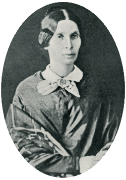

Harriet Gore Handy Tingle Stevenson
| Birth | : | 18 May 1804 Maryland, USA |
| Death | : | 30 Apr 1853 Pocomoke City, Worcester County, Maryland, USA |
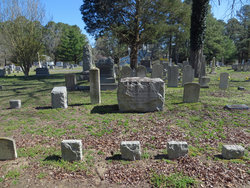
| Burial | : | Pitts Creek Presbyterian Cemetery, Pocomoke City, Worcester County, USA |
| Coordinate | : | 38.0793686, -75.5653076 |
| Description | : | Harriet G. H. Stevenson was buried in the family's private burial plot between the Methodist Episcopal Church and the River, and her remains and tomb and those of her son James T., were later removed to the Pitts Creek Presbyterian Cemetery. Harriett was the daughter of Judge William Tingle of Snow Hill, MD and his wife, Sally Long. She married John Slemmons Stevenson on 23 May 1827 in Worcester County, Maryland. They were the parents of: 1) Sarah Ann (23 Apr 1828—1860) 2) Edward William (15 Feb 1830— 3) Elizabeth Grace (3 Sep 1831—1903) 4) David Long (26 Feb 1833—28 Aug 1912) 5) John Henry (20 Oct... Read More |
frequently asked questions (FAQ):
-
Where is Harriet Gore Handy Tingle Stevenson's memorial?
Harriet Gore Handy Tingle Stevenson's memorial is located at: Pitts Creek Presbyterian Cemetery, Pocomoke City, Worcester County, USA.
-
When did Harriet Gore Handy Tingle Stevenson death?
Harriet Gore Handy Tingle Stevenson death on 30 Apr 1853 in Pocomoke City, Worcester County, Maryland, USA
-
Where are the coordinates of the Harriet Gore Handy Tingle Stevenson's memorial?
Latitude: 38.0793686
Longitude: -75.5653076
Family Members:
Spouse
Children
Flowers:


Nearby Cemetories:
1. Pitts Creek Presbyterian Cemetery
Pocomoke City, Worcester County, USA
Coordinate: 38.0793686, -75.5653076
2. Bethany United Methodist Church Cemetery
Pocomoke City, Worcester County, USA
Coordinate: 38.0754420, -75.5655290
3. Saint Marys Cemetery
Pocomoke City, Worcester County, USA
Coordinate: 38.0744019, -75.5661011
4. First Baptist Cemetery
Pocomoke City, Worcester County, USA
Coordinate: 38.0774220, -75.5471510
5. Mount Zion United Methodist Church Cemetery
Pocomoke City, Worcester County, USA
Coordinate: 38.0762850, -75.5464160
6. Salem Methodist Church Cemetery
Pocomoke City, Worcester County, USA
Coordinate: 38.0663986, -75.5802994
7. Tindleys Chapel Community and Memorial Park
West Pocomoke, Somerset County, USA
Coordinate: 38.0971781, -75.5663652
8. Holy Name of Jesus Churchyard
Pocomoke City, Worcester County, USA
Coordinate: 38.0626898, -75.5521236
9. Bratten Family Plot
Cokesbury, Somerset County, USA
Coordinate: 38.1051500, -75.5504100
10. Trinity Cemetery
Pocomoke City, Worcester County, USA
Coordinate: 38.0614014, -75.5994034
11. Quinton Cemetery
West Pocomoke, Somerset County, USA
Coordinate: 38.0964012, -75.6085968
12. Georgetown Baptist Church Cemetery
Snow Hill, Worcester County, USA
Coordinate: 38.0915580, -75.5160020
13. Cokesbury United Methodist Church Cemetery
Cokesbury, Somerset County, USA
Coordinate: 38.1248100, -75.5765140
14. Christ Church Cemetery
Westover, Somerset County, USA
Coordinate: 38.0795259, -75.6316964
15. Goodwill Cemetery
Goodwill, Worcester County, USA
Coordinate: 38.0667000, -75.5000000
16. Costen Family Plot
Dublin, Somerset County, USA
Coordinate: 38.1315440, -75.5930350
17. Pitts Creek Baptist Church Cemetery
Pocomoke City, Worcester County, USA
Coordinate: 38.0349000, -75.6131560
18. Old Shiloh Cemetery
Worcester County, USA
Coordinate: 38.1044006, -75.4882965
19. Old Shiloh Cemetery
Pocomoke City, Worcester County, USA
Coordinate: 38.1044960, -75.4878110
20. Pitts Creek Cemetery
Pocomoke City, Worcester County, USA
Coordinate: 38.0200005, -75.6108017
21. Saint James Cemetery
Pocomoke City, Worcester County, USA
Coordinate: 38.0083008, -75.5836029
22. Shiloh Cemetery
Worcester County, USA
Coordinate: 38.0974998, -75.4760971
23. Holly Grove Mennonite Church Cemetery
Westover, Somerset County, USA
Coordinate: 38.0827612, -75.6655717
24. Nelson Cemetery
New Church, Accomack County, USA
Coordinate: 38.0017724, -75.5392648