
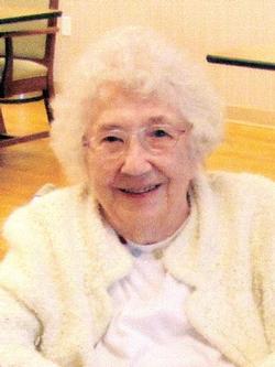

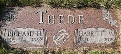
Harriett Mae Cramblet Thede
| Birth | : | 17 Jul 1921 Pine River, Cass County, Minnesota, USA |
| Death | : | 24 Nov 2015 Boone County, Iowa, USA |
| Burial | : | Boone Memorial Gardens Cemetery, Boone, Boone County, USA |
| Coordinate | : | 42.0449982, -93.9152985 |
| Description | : | Harriett Thede, age 94, of Boone and the Westhaven Community, died November 24, 2015, at Westhaven. Harriett Mae Thede was born in Pine River, Minnesota, the daughter of Joshua and Ethel (Smith) Cramblet. She graduated from high school in Alliance, Nebraska. On May 10, 1947, Harriett married Richard Thede in Cozad, Nebraska. For many years, Harriett worked for the Iowa Department of Transportation in Ames as a financial secretary, retiring in 1979. She was a member of First Baptist Church and she and Richard were soldiers with the Boone Salvation Army. Harriett loved music and she formed ‘Harriett Thede’s Gospel Group’ which traveled 14... Read More |
frequently asked questions (FAQ):
-
Where is Harriett Mae Cramblet Thede's memorial?
Harriett Mae Cramblet Thede's memorial is located at: Boone Memorial Gardens Cemetery, Boone, Boone County, USA.
-
When did Harriett Mae Cramblet Thede death?
Harriett Mae Cramblet Thede death on 24 Nov 2015 in Boone County, Iowa, USA
-
Where are the coordinates of the Harriett Mae Cramblet Thede's memorial?
Latitude: 42.0449982
Longitude: -93.9152985
Family Members:
Parent

Spouse
Siblings
Flowers:


Nearby Cemetories:
1. Boone Memorial Gardens Cemetery
Boone, Boone County, USA
Coordinate: 42.0449982, -93.9152985
2. Biblical College Cemetery
Boone, Boone County, USA
Coordinate: 42.0456009, -93.9113998
3. Sacred Heart Cemetery
Boone, Boone County, USA
Coordinate: 42.0485992, -93.9163971
4. Rose Hill Cemetery
Boone, Boone County, USA
Coordinate: 42.0419006, -93.9408035
5. Latham Cemetery
Boone, Boone County, USA
Coordinate: 42.0489006, -93.8878021
6. Linwood Park Cemetery
Boone, Boone County, USA
Coordinate: 42.0550003, -93.8850021
7. Oakwood Cemetery
Moingona, Boone County, USA
Coordinate: 42.0219002, -93.9396973
8. Sarah Dinwoodie Cemetery
Worth Township, Boone County, USA
Coordinate: 42.0278000, -93.8697000
9. Hollaway Cemetery
Moingona, Boone County, USA
Coordinate: 42.0138720, -93.9530080
10. Quincy Cemetery
Boone, Boone County, USA
Coordinate: 42.0074997, -93.9503021
11. Bass Point Cemetery
Boone, Boone County, USA
Coordinate: 42.0992012, -93.8957977
12. Bluff Creek Cemetery
Boone, Boone County, USA
Coordinate: 42.0774994, -93.9796982
13. Buckley Cemetery
Boone, Boone County, USA
Coordinate: 42.0999810, -93.9418960
14. Squire Boone Cemetery
Luther, Boone County, USA
Coordinate: 42.0032997, -93.8531036
15. Hickory Grove Cemetery
Boone County, USA
Coordinate: 42.1074982, -93.9507980
16. Sparks Cemetery
Boone County, USA
Coordinate: 41.9728012, -93.9191971
17. Pleasant Hill Cemetery
Boone, Boone County, USA
Coordinate: 41.9618988, -93.9492035
18. Hull Cemetery
Luther, Boone County, USA
Coordinate: 41.9603004, -93.8664017
19. Saint Johns Catholic Cemetery
Ogden, Boone County, USA
Coordinate: 42.0344000, -94.0407000
20. Glenwood Cemetery
Ogden, Boone County, USA
Coordinate: 42.0340000, -94.0440000
21. Swede Valley Lutheran Church Cemetery
Ogden, Boone County, USA
Coordinate: 41.9770000, -94.0285000
22. Schlicht Cemetery
Fraser, Boone County, USA
Coordinate: 42.1444200, -93.9780100
23. Boone County Poor Farm Cemetery
Boone County, USA
Coordinate: 42.1591100, -93.9159000
24. Maas Cemetery
Boone County, USA
Coordinate: 42.0908012, -94.0618973