
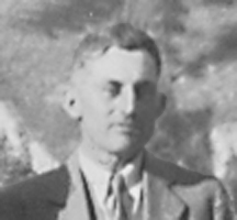
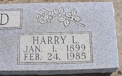
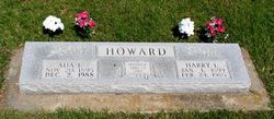
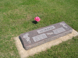
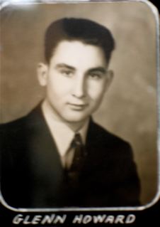
Harry Lee Howard
| Birth | : | 1 Jan 1899 Mulvane, Sumner County, Kansas, USA |
| Death | : | 24 Feb 1985 Yates Center, Woodson County, Kansas, USA |
| Burial | : | Indianapolis Cemetery, Rose Hill, Mahaska County, USA |
| Coordinate | : | 41.4053001, -92.4364014 |
| Plot | : | Block 14, Lot 29, Grave S1/3 |
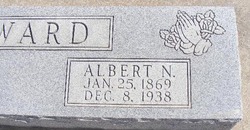
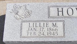
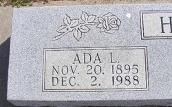
| Description | : | Obituary from Wichita Eagle: "Yates Center, Kans., Feb. 26, 1985 "Harry L. Howard, 86, retired farmer, died Sunday. Services at 10:30 a.m., Wednesday, Campbell Funeral Home. Mulvane Cemetery 3 p.m. "Survivors: wife, Ada L.; sons, . . . [two]; daughters, . . . , and Betty Patterson of Yates Center. 11 grandchildren and 12 great grandchildren. " Obituary from unnamed newspaper, probably Yates Center News: Harry Lee Howard Harry Lee Howard, son of Albert and Lillie Smith Howard, was born at Mulvane,... Read More |
frequently asked questions (FAQ):
-
Where is Harry Lee Howard's memorial?
Harry Lee Howard's memorial is located at: Indianapolis Cemetery, Rose Hill, Mahaska County, USA.
-
When did Harry Lee Howard death?
Harry Lee Howard death on 24 Feb 1985 in Yates Center, Woodson County, Kansas, USA
-
Where are the coordinates of the Harry Lee Howard's memorial?
Latitude: 41.4053001
Longitude: -92.4364014
Family Members:
Parent
Spouse
Siblings

Children

Flowers:


Nearby Cemetories:
1. Indianapolis Cemetery
Rose Hill, Mahaska County, USA
Coordinate: 41.4053001, -92.4364014
2. Tinsley Cemetery
Mahaska County, USA
Coordinate: 41.3941994, -92.4783020
3. Bedwell Cemetery
Monroe Township, Mahaska County, USA
Coordinate: 41.3667400, -92.4637400
4. Rice Cemetery
What Cheer, Keokuk County, USA
Coordinate: 41.3793983, -92.3891983
5. Coal Creek Cemetery
What Cheer, Keokuk County, USA
Coordinate: 41.4392520, -92.3843340
6. Hopewell Cemetery
Rose Hill, Mahaska County, USA
Coordinate: 41.3502998, -92.4494019
7. Waddell Cemetery
Keokuk County, USA
Coordinate: 41.3574982, -92.3874969
8. Mormon Point Cemetery
Mahaska County, USA
Coordinate: 41.4344406, -92.5080566
9. Turner-Tinkerville-Wapalo Cemetery
Rose Hill, Mahaska County, USA
Coordinate: 41.3426130, -92.4177970
10. Roberts Cemetery
Mahaska County, USA
Coordinate: 41.3793983, -92.5235977
11. Highland Cemetery
What Cheer, Keokuk County, USA
Coordinate: 41.3936005, -92.3407974
12. McFarlan Cemetery
What Cheer, Keokuk County, USA
Coordinate: 41.4085999, -92.3371964
13. Wymore Cemetery
Rose Hill, Mahaska County, USA
Coordinate: 41.3499985, -92.5069427
14. Saint Josephs Cemetery
What Cheer, Keokuk County, USA
Coordinate: 41.4007988, -92.3300018
15. Sixteen Cemetery
Thornburg, Keokuk County, USA
Coordinate: 41.4622002, -92.3538971
16. Hewitt Cemetery
Delta, Keokuk County, USA
Coordinate: 41.3277874, -92.3807409
17. Jackson Cemetery
Rose Hill, Mahaska County, USA
Coordinate: 41.3191986, -92.4730988
18. Springfield Cemetery
Delta, Keokuk County, USA
Coordinate: 41.3386002, -92.3531036
19. Old Rose Hill Cemetery
Rose Hill, Mahaska County, USA
Coordinate: 41.3209991, -92.4929962
20. Ruby Cemetery
Lacey, Mahaska County, USA
Coordinate: 41.3633320, -92.5527550
21. Barnes City Cemetery
Barnes City, Mahaska County, USA
Coordinate: 41.5036390, -92.4746930
22. Saint Martin Evangelical Lutheran Cemetery
Keokuk County, USA
Coordinate: 41.4100075, -92.2971268
23. Humes Cemetery
Thornburg, Keokuk County, USA
Coordinate: 41.4085999, -92.2968979
24. Union Mills Cemetery
Union Mills, Mahaska County, USA
Coordinate: 41.4482994, -92.5643997