
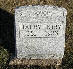
Harry Randol Perry
| Birth | : | 2 Apr 1881 Clarence, Shelby County, Missouri, USA |
| Death | : | 1928 Clarence, Shelby County, Missouri, USA |
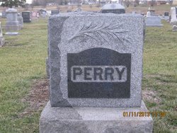
| Burial | : | Maplewood Cemetery, Clarence, Shelby County, USA |
| Coordinate | : | 39.7508011, -92.2572021 |
| Plot | : | AOUW Block 3 Row 3 Lot 24s |
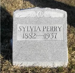
| Description | : | Clarence, Shelby, Missouri, 1928 Farmer Dies While Plowing. Harry Perry, Prominent Farmer, a Victim of Heart Trouble. Harry Perry, of south of Clarence, dropped dead while plowing corn Monday morning, his death was due to heart trouble. He was riding on a cultivator plowing corn when he was seen to fall from the plow about nine o'clock. Harry Randol Perry, son of Oliver Commodore Perry and Ellen S. Perry, was born April 2, 1881, near Clarence. October 7, 1913 he was married to Sylvia Straub, of Liberty, who with their two little daughters, Doris Irene and Marie Ellen, are left to mourn his passing.... Read More |
frequently asked questions (FAQ):
-
Where is Harry Randol Perry's memorial?
Harry Randol Perry's memorial is located at: Maplewood Cemetery, Clarence, Shelby County, USA.
-
When did Harry Randol Perry death?
Harry Randol Perry death on 1928 in Clarence, Shelby County, Missouri, USA
-
Where are the coordinates of the Harry Randol Perry's memorial?
Latitude: 39.7508011
Longitude: -92.2572021
Family Members:
Parent

Spouse
Siblings

Flowers:


Nearby Cemetories:
1. Maplewood Cemetery
Clarence, Shelby County, USA
Coordinate: 39.7508011, -92.2572021
2. Clarence City Cemetery
Clarence, Shelby County, USA
Coordinate: 39.7493750, -92.2624800
3. Saint Patricks Cemetery
Clarence, Shelby County, USA
Coordinate: 39.7352982, -92.2714005
4. Hopper Cemetery
Shelby County, USA
Coordinate: 39.8083000, -92.2683029
5. Amish Cemetery
Macon County, USA
Coordinate: 39.7858009, -92.3208008
6. Hawkins Cemetery
Shelby County, USA
Coordinate: 39.8111000, -92.2874985
7. Bethel Christian Church Cemetery
Anabel, Macon County, USA
Coordinate: 39.8018200, -92.3252200
8. Patton Cemetery
Hagers Grove, Shelby County, USA
Coordinate: 39.8155700, -92.2022800
9. Ebenezer Cemetery
Hagers Grove, Shelby County, USA
Coordinate: 39.8302994, -92.2652969
10. Walker Cemetery
Macon County, USA
Coordinate: 39.6823640, -92.3117360
11. Winn Family Cemetery
Macon County, USA
Coordinate: 39.7589684, -92.3646774
12. Hagers Grove Cemetery
Hagers Grove, Shelby County, USA
Coordinate: 39.8305000, -92.2236000
13. Ewing Cemetery
Macon County, USA
Coordinate: 39.7616997, -92.3688965
14. Union Grove Cemetery
Clarence, Shelby County, USA
Coordinate: 39.6630360, -92.2602920
15. Ten Mile Baptist Church Cemetery
Ten Mile, Macon County, USA
Coordinate: 39.8082120, -92.3440980
16. Bethlehem Cemetery
Macon, Macon County, USA
Coordinate: 39.7070007, -92.3570023
17. Brown Cemetery
Macon County, USA
Coordinate: 39.7499140, -92.3723280
18. Sage Cemetery
Macon County, USA
Coordinate: 39.6738570, -92.3175640
19. Graves Chapel Cemetery
Anabel, Macon County, USA
Coordinate: 39.6815900, -92.3337200
20. Bacon Chapel Cemetery
Shelbyville, Shelby County, USA
Coordinate: 39.7511487, -92.1368436
21. Morris Cemetery
Shelby County, USA
Coordinate: 39.8227997, -92.1808014
22. Mount Hope Cemetery
Shelby County, USA
Coordinate: 39.7930984, -92.1442032
23. Harris Graveyard
Woodville, Macon County, USA
Coordinate: 39.6863850, -92.3543810
24. Mitts Cemetery
Macon County, USA
Coordinate: 39.8466988, -92.2913971