
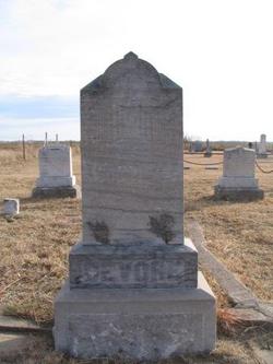

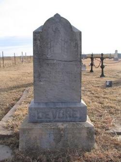
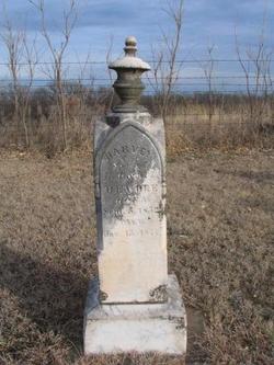
Harvey Jack DeVore
| Birth | : | 27 Jan 1828 Athens, Athens County, Ohio, USA |
| Death | : | 20 Dec 1914 Harper County, Kansas, USA |
| Burial | : | Woodlands Cemetery, Gillingham, Medway Unitary Authority, England |
| Coordinate | : | 51.3839989, 0.5680000 |
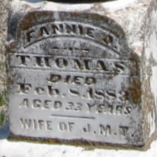
| Description | : | Harvey was the third of 6 children to Benjamin DeVore and Harriet. Ben was born in Pennsylvania and Harriet born in Virginia. Harvey's siblings were: Willis, William, Allen, Charlette, and Franklin. Harvey married Naomi Tucker on 27 Feb. 1848. Harvey and Naomi had 9 children. Correct me if I'm wrong: Fanny J. Thomas, Mary Jane Wolf, Louisa Samantha Wells, Charolette, Franklin DeVore, William alexander DeVore and Zeralada Belle Butler. I put the females with their marriage last names. If i'm wrong let me know! Both Harvey and Naomia are buried at the DeVore Cemetery plus his father Benjamin and others. |
frequently asked questions (FAQ):
-
Where is Harvey Jack DeVore's memorial?
Harvey Jack DeVore's memorial is located at: Woodlands Cemetery, Gillingham, Medway Unitary Authority, England.
-
When did Harvey Jack DeVore death?
Harvey Jack DeVore death on 20 Dec 1914 in Harper County, Kansas, USA
-
Where are the coordinates of the Harvey Jack DeVore's memorial?
Latitude: 51.3839989
Longitude: 0.5680000
Family Members:
Parent
Spouse
Siblings

Children
Flowers:


Nearby Cemetories:
1. Woodlands Cemetery
Gillingham, Medway Unitary Authority, England
Coordinate: 51.3839989, 0.5680000
2. Grange Road Cemetery
Gillingham, Medway Unitary Authority, England
Coordinate: 51.3902512, 0.5639850
3. St Mary Magdalene Churchyard
Gillingham, Medway Unitary Authority, England
Coordinate: 51.3903530, 0.5622230
4. St. Barnabas Church
Gillingham, Medway Unitary Authority, England
Coordinate: 51.3801400, 0.5505370
5. St. Augustine's Church
Gillingham, Medway Unitary Authority, England
Coordinate: 51.3745050, 0.5474930
6. Christ Church Cemetery
Chatham, Medway Unitary Authority, England
Coordinate: 51.3716730, 0.5462690
7. Chatham Naval Memorial
Chatham, Medway Unitary Authority, England
Coordinate: 51.3836479, 0.5321670
8. St George Churchyard
Chatham, Medway Unitary Authority, England
Coordinate: 51.3974070, 0.5346770
9. Chatham Burial Ground
Chatham, Medway Unitary Authority, England
Coordinate: 51.3849900, 0.5272600
10. Brompton War Memorial
Chatham, Medway Unitary Authority, England
Coordinate: 51.3932140, 0.5293660
11. St Mary Churchyard
Chatham, Medway Unitary Authority, England
Coordinate: 51.3874550, 0.5244280
12. Chatham Unitarian Church
Chatham, Medway Unitary Authority, England
Coordinate: 51.3826090, 0.5195850
13. Chatham Palmerston Road Cemetery
Chatham, Medway Unitary Authority, England
Coordinate: 51.3678600, 0.5267300
14. Chatham Maidstone Road Cemetery
Chatham, Medway Unitary Authority, England
Coordinate: 51.3703300, 0.5227600
15. St Margaret Churchyard
Rainham, Medway Unitary Authority, England
Coordinate: 51.3629990, 0.6085000
16. St. Werburgh Churchyard
Hoo St Werburgh, Medway Unitary Authority, England
Coordinate: 51.4176500, 0.5634340
17. Fort Pitt Military Cemetery
Rochester, Medway Unitary Authority, England
Coordinate: 51.3769790, 0.5114570
18. St Philip and St James Churchyard
Upnor, Medway Unitary Authority, England
Coordinate: 51.4106250, 0.5250480
19. Rochester Baptist Church
Rochester, Medway Unitary Authority, England
Coordinate: 51.3871570, 0.5052370
20. St Nicholas Churchyard
Rochester, Medway Unitary Authority, England
Coordinate: 51.3894170, 0.5035320
21. Rochester Cathedral
Rochester, Medway Unitary Authority, England
Coordinate: 51.3889750, 0.5031160
22. Rochester Castle Moat Burial Ground
Rochester, Medway Unitary Authority, England
Coordinate: 51.3894140, 0.5024580
23. St. Nicholas's Cemetery
Rochester, Medway Unitary Authority, England
Coordinate: 51.3780081, 0.5021076
24. All Saints Churchyard
Frindsbury, Medway Unitary Authority, England
Coordinate: 51.4004440, 0.5058970