
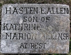
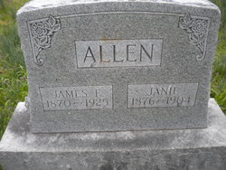
Hasten E. Allen
| Birth | : | Feb 1884 Missouri, USA |
| Death | : | unknown |
| Burial | : | Tecumseh Cemetery, Tecumseh, Johnson County, USA |
| Coordinate | : | 40.3645000, -96.1800000 |
| Description | : | Son of Marion Allen and Nancy (Huff) Allen. No dates on stone. Memorial originally posted with the incorrect death date (belonging to Frederick Haston Allen). |
frequently asked questions (FAQ):
-
Where is Hasten E. Allen's memorial?
Hasten E. Allen's memorial is located at: Tecumseh Cemetery, Tecumseh, Johnson County, USA.
-
When did Hasten E. Allen death?
Hasten E. Allen death on unknown in
-
Where are the coordinates of the Hasten E. Allen's memorial?
Latitude: 40.3645000
Longitude: -96.1800000
Family Members:
Parent
Siblings
Flowers:


Nearby Cemetories:
1. Tecumseh Cemetery
Tecumseh, Johnson County, USA
Coordinate: 40.3645000, -96.1800000
2. Saint Andrews Cemetery
Tecumseh, Johnson County, USA
Coordinate: 40.3918991, -96.1999969
3. Spring Creek Cemetery
Johnson County, USA
Coordinate: 40.3992004, -96.1222000
4. Grandview Cemetery
Elk Creek, Johnson County, USA
Coordinate: 40.3274994, -96.1042023
5. Mount Hope Cemetery
Elk Creek, Johnson County, USA
Coordinate: 40.2976000, -96.1406000
6. Saint Pauls United Church of Christ Cemetery
Tecumseh, Johnson County, USA
Coordinate: 40.2996000, -96.2742000
7. Saint Frederick Cemetery
Johnson, Nemaha County, USA
Coordinate: 40.3671989, -96.0475006
8. Holy Rosary Catholic Cemetery
Saint Mary, Johnson County, USA
Coordinate: 40.4280000, -96.2905000
9. Saint Peters Lutheran Church Cemetery
Steinauer, Pawnee County, USA
Coordinate: 40.2555000, -96.1801000
10. Mount Hope Church Cemetery
Cook, Johnson County, USA
Coordinate: 40.4775000, -96.1233000
11. Vesta Cemetery
Johnson County, USA
Coordinate: 40.3630981, -96.3414001
12. Martin Luther Church Cemetery
Nemaha County, USA
Coordinate: 40.3345040, -96.0098670
13. Saint Matthews Lutheran Cemetery
Johnson, Nemaha County, USA
Coordinate: 40.4073060, -96.0086500
14. Rinne Cemetery
Pawnee County, USA
Coordinate: 40.2472000, -96.2742004
15. Johnson Cemetery
Johnson, Nemaha County, USA
Coordinate: 40.4142000, -96.0052300
16. Trinity Lutheran Cemetery
Nemaha County, USA
Coordinate: 40.3058014, -96.0093994
17. Zion Lutheran Church Cemetery
Johnson, Nemaha County, USA
Coordinate: 40.4287000, -96.0099000
18. Clear Creek Cemetery
Table Rock, Pawnee County, USA
Coordinate: 40.2193985, -96.1391983
19. Livingston Cemetery
Cook, Johnson County, USA
Coordinate: 40.5080986, -96.1235962
20. Cook Cemetery
Cook, Johnson County, USA
Coordinate: 40.5168991, -96.1797028
21. Helena Cemetery
Johnson County, USA
Coordinate: 40.5085983, -96.2457962
22. Saint James Lutheran Cemetery
Nemaha County, USA
Coordinate: 40.2757500, -96.0161500
23. Grace Lutheran Church Cemetery
Cook, Johnson County, USA
Coordinate: 40.5178000, -96.1799500
24. Mount Zion Cemetery
Nemaha County, USA
Coordinate: 40.2761002, -96.0113983