
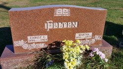
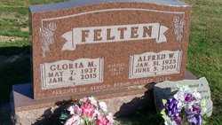
| Birth | : | 5 Aug 1918 Cherokee County, Iowa, USA |
| Death | : | 13 Jun 1990 Aurelia, Cherokee County, Iowa, USA |
| Burial | : | Mountain View Memorial Park, Boulder, Boulder County, USA |
| Coordinate | : | 40.0391300, -105.2503100 |
| Plot | : | Blk 5N, lot 1, grv 5 |
| Description | : | Married 31 Jan 1940 in Peterson, Buena Vista Co., Iowa at St. John's Lutheran Church to Clarence Sump Married 2nd after the death of her 1st husband Ervan Oliver Judson on 22 Dec 1979 in Cherokee, Cherokee Co., Iowa at the home of the bride to be. |
frequently asked questions (FAQ):
-
Where is Helen Berniece Felten Sump's memorial?
Helen Berniece Felten Sump's memorial is located at: Mountain View Memorial Park, Boulder, Boulder County, USA.
-
When did Helen Berniece Felten Sump death?
Helen Berniece Felten Sump death on 13 Jun 1990 in Aurelia, Cherokee County, Iowa, USA
-
Where are the coordinates of the Helen Berniece Felten Sump's memorial?
Latitude: 40.0391300
Longitude: -105.2503100
Family Members:
Parent

Spouse

Siblings
Flowers:


Nearby Cemetories:
1. Mountain View Memorial Park
Boulder, Boulder County, USA
Coordinate: 40.0391300, -105.2503100
2. Saint Johns Episcopal Church Columbarium
Boulder, Boulder County, USA
Coordinate: 40.0206000, -105.2780000
3. Saint Aidans Episcopal Church Columbarium
Boulder, Boulder County, USA
Coordinate: 40.0085000, -105.2628000
4. Valmont Cemetery
Valmont, Boulder County, USA
Coordinate: 40.0293999, -105.2071991
5. Poor Farm Cemetery
Boulder, Boulder County, USA
Coordinate: 40.0454950, -105.2054940
6. Grace Lutheran Church Columbarium
Boulder, Boulder County, USA
Coordinate: 40.0056000, -105.2766000
7. Columbia Cemetery
Boulder, Boulder County, USA
Coordinate: 40.0083008, -105.2825012
8. Saint Andrews Presbyterian Church Columbarium
Boulder, Boulder County, USA
Coordinate: 39.9993000, -105.2465000
9. Green Mountain Cemetery
Boulder, Boulder County, USA
Coordinate: 39.9947014, -105.2671967
10. Sacred Heart of Mary Cemetery
Boulder, Boulder County, USA
Coordinate: 39.9891663, -105.1958313
11. Niwot Cemetery
Niwot, Boulder County, USA
Coordinate: 40.1130981, -105.1847000
12. Sunshine Cemetery
Sunshine, Boulder County, USA
Coordinate: 40.0598450, -105.3651581
13. Salina Cemetery
Salina, Boulder County, USA
Coordinate: 40.0568000, -105.3801000
14. Ryssby Cemetery
Longmont, Boulder County, USA
Coordinate: 40.1396190, -105.2055190
15. Eldorado Springs Cemetery
Eldorado Springs, Boulder County, USA
Coordinate: 39.9336510, -105.2709500
16. Superior Cemetery
Superior, Boulder County, USA
Coordinate: 39.9514008, -105.1557999
17. Jamestown Cemetery
Jamestown, Boulder County, USA
Coordinate: 40.1111310, -105.3792340
18. Coal Creek Cemetery
Louisville, Boulder County, USA
Coordinate: 39.9728000, -105.1140000
19. Gold Hill Cemetery
Gold Hill, Boulder County, USA
Coordinate: 40.0567017, -105.4103012
20. Louisville Cemetery
Louisville, Boulder County, USA
Coordinate: 39.9730988, -105.1091995
21. Lafayette Cemetery
Lafayette, Boulder County, USA
Coordinate: 40.0009000, -105.0925000
22. Monarch Number 2 Coal Mine Monument
Broomfield, Broomfield County, USA
Coordinate: 39.9365270, -105.1378080
23. Pratt Cemetery
Longmont, Boulder County, USA
Coordinate: 40.1419000, -105.1221000
24. Burlington Cemetery
Longmont, Boulder County, USA
Coordinate: 40.1417007, -105.1200027