


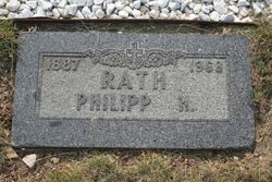
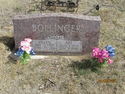
Helen Betty Rath Bollinger
| Birth | : | 2 May 1925 Jordan, Garfield County, Montana, USA |
| Death | : | 23 Jun 2016 Jordan, Garfield County, Montana, USA |
| Burial | : | Pioneer Cemetery, Jordan, Garfield County, USA |
| Coordinate | : | 47.3244019, -106.9238968 |
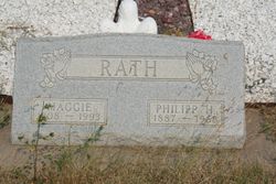
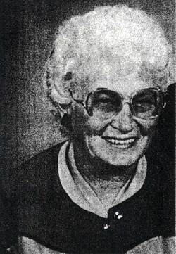
| Description | : | Helen Rath Bollinger, 91, of Jordan, MT passed away Thursday, June 23, 2016 at the Garfield County Health Center in Jordan, MT. She entered this world on May 2, 1925 at Jordan, Montana, the 1st born of Maggie and Phillip Rath. She married Arthur Bollinger on January 28, 1941. Art and Helen lived in Jordan their entire life. Helen worked at various jobs while raising her 3 daughters. She always felt honored having been one of the first cooks when Garfield County Schools started their lunch program. She was an avid Mustangs fan, especially loving basketball, spending many years and traveling many... Read More |
frequently asked questions (FAQ):
-
Where is Helen Betty Rath Bollinger's memorial?
Helen Betty Rath Bollinger's memorial is located at: Pioneer Cemetery, Jordan, Garfield County, USA.
-
When did Helen Betty Rath Bollinger death?
Helen Betty Rath Bollinger death on 23 Jun 2016 in Jordan, Garfield County, Montana, USA
-
Where are the coordinates of the Helen Betty Rath Bollinger's memorial?
Latitude: 47.3244019
Longitude: -106.9238968
Family Members:
Parent
Spouse
Siblings


Flowers:


Nearby Cemetories:
1. Pioneer Cemetery
Jordan, Garfield County, USA
Coordinate: 47.3244019, -106.9238968
2. Greenridge Cemetery
Jordan, Garfield County, USA
Coordinate: 47.3389015, -106.8946991
3. Hinther Cemetery
Garfield County, USA
Coordinate: 47.2685000, -107.0218000
4. Butte Creek Cemetery
Garfield County, USA
Coordinate: 47.4777985, -107.2341995
5. Steve Forks Cemetery
Garfield County, USA
Coordinate: 47.2627983, -107.3321991
6. Cohagen Cemetery
Cohagen, Garfield County, USA
Coordinate: 47.0772018, -106.6232986
7. Darnall-Armbruster-Hubbard Family Cemetery
Garfield County, USA
Coordinate: 47.6407000, -107.0645200
8. Neudorfer Cemetery
Jordan, Garfield County, USA
Coordinate: 47.2095000, -106.2772000
9. Hearts at Peace Cemetery
Brusett, Garfield County, USA
Coordinate: 47.5441900, -107.5399200
10. Wolf Cemetery
Garfield County, USA
Coordinate: 47.1528015, -107.5924988
11. Vanstel Cemetery
Rosebud County, USA
Coordinate: 46.7872009, -106.8942032
12. Haglunds Ritchie Cemetery
McCone County, USA
Coordinate: 47.3246994, -106.0639038
13. Biebers Cemetery
McCone County, USA
Coordinate: 47.2386100, -106.0348800
14. Biebers Cemetery
McCone County, USA
Coordinate: 47.2257600, -106.0220400
15. Watkins Cemetery
McCone County, USA
Coordinate: 47.1808014, -105.9811020
16. Coon Cemetery
Garfield County, USA
Coordinate: 47.3263790, -107.9323320
17. Gilfeather Cemetery
Benzien, Garfield County, USA
Coordinate: 47.2348310, -107.9476920
18. Fort Peck Cemetery
Valley County, USA
Coordinate: 48.0069008, -106.4599991
19. Rock Springs Cemetery
Rock Springs, Rosebud County, USA
Coordinate: 46.7847800, -106.1411500
20. Fort Peck Dam Disaster Memorial
Valley County, USA
Coordinate: 48.0083000, -106.4003000
21. Brockway Cemetery
McCone County, USA
Coordinate: 47.2963982, -105.7514038
22. Brost Cemetery
McCone County, USA
Coordinate: 47.2971992, -105.7457962
23. Galpin Cemetery
Valley County, USA
Coordinate: 48.0732994, -106.4692001
24. Sumatra Cemetery
Rosebud County, USA
Coordinate: 46.6136017, -107.5674973