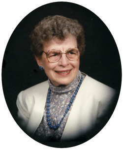
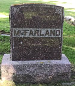
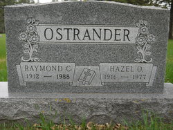
Helen Elaine Ortberg McFarland
| Birth | : | 13 Oct 1919 Raymond Township, Clark County, South Dakota, USA |
| Death | : | 3 May 2008 Watertown, Codington County, South Dakota, USA |
| Burial | : | Naracoorte Cemetery, Naracoorte, Naracoorte Lucindale Council, Australia |
| Coordinate | : | -36.9460270, 140.7302250 |
| Description | : | Helen Goodroad, age 88, was the daughter of Edgar and Edith (Carroll) Ortberg. She graduated from Ash Consolidated High School in 1937. She married Ervin McFarland in June 1944, married Raymond Ostrander in 1979, married Leroy Goodroad in December 1991. She was preceded in death by her parents, three husbands, her sister, Gladys LaBay, and two step-children. She is survived by her children, Connie Mausbach and Muriel Behrens, her siblings, Conrad Ortberg and Norma Weelborg, four grandchildren, five great-grandchildren, and numerous step-children, step-grandchildren, and step-great-grandchildren. Funeral services were held at First Congregational United Church of Christ. |
frequently asked questions (FAQ):
-
Where is Helen Elaine Ortberg McFarland's memorial?
Helen Elaine Ortberg McFarland's memorial is located at: Naracoorte Cemetery, Naracoorte, Naracoorte Lucindale Council, Australia.
-
When did Helen Elaine Ortberg McFarland death?
Helen Elaine Ortberg McFarland death on 3 May 2008 in Watertown, Codington County, South Dakota, USA
-
Where are the coordinates of the Helen Elaine Ortberg McFarland's memorial?
Latitude: -36.9460270
Longitude: 140.7302250
Family Members:
Flowers:
Nearby Cemetories:
1. Naracoorte Cemetery
Naracoorte, Naracoorte Lucindale Council, Australia
Coordinate: -36.9460270, 140.7302250
2. Hynam Cemetery
Naracoorte Lucindale Council, Australia
Coordinate: -36.9393410, 140.8490120
3. Moyhall Homestead
Naracoorte Lucindale Council, Australia
Coordinate: -37.0585750, 140.6699470
4. Burnside Cemetery
Naracoorte, Naracoorte Lucindale Council, Australia
Coordinate: -36.7925600, 140.6600300
5. Kybybolite Cemetery
Kybybolite, Naracoorte Lucindale Council, Australia
Coordinate: -36.8815610, 140.9291740
6. Lucindale Cemetery
Lucindale, Naracoorte Lucindale Council, Australia
Coordinate: -36.9696190, 140.3797090
7. Apsley Cemetery
Apsley, West Wimmera Shire, Australia
Coordinate: -36.9589380, 141.0837570
8. Frances Cemetery
Frances, Naracoorte Lucindale Council, Australia
Coordinate: -36.7032530, 140.9614290
9. Minimay Cemetery
Minimay, West Wimmera Shire, Australia
Coordinate: -36.7228070, 141.1613810
10. Penola Old Cemetery
Penola, Wattle Range Council, Australia
Coordinate: -37.3670740, 140.8412400
11. Penola Cemetery
Penola, Wattle Range Council, Australia
Coordinate: -37.4009210, 140.8362800
12. Edenhope Cemetery
Edenhope, West Wimmera Shire, Australia
Coordinate: -37.0421400, 141.3039580
13. Dergholm Cemetery
Dergholm, West Wimmera Shire, Australia
Coordinate: -37.3717520, 141.2253000
14. Karnak Cemetery
Karnak, West Wimmera Shire, Australia
Coordinate: -36.8234670, 141.4826510
15. Kalangadoo Cemetery
Kalangadoo, Wattle Range Council, Australia
Coordinate: -37.5694190, 140.7045780
16. Chetwynd Cemetery
Chetwynd, West Wimmera Shire, Australia
Coordinate: -37.2791510, 141.3951660
17. Goroke Public Cemetery
Goroke, West Wimmera Shire, Australia
Coordinate: -36.7137300, 141.4900600
18. Kaniva Cemetery
Kaniva, West Wimmera Shire, Australia
Coordinate: -36.3566100, 141.1826590
19. Heathfield Cemetery
Lake Mundi, Glenelg Shire, Australia
Coordinate: -37.5713233, 141.1436213
20. Millicent Cemetery
Millicent, Wattle Range Council, Australia
Coordinate: -37.6184335, 140.3770980
21. Harrow Cemetery
Harrow, Southern Grampians Shire, Australia
Coordinate: -37.1566380, 141.6217120
22. Beachport Cemetery
Beachport, Wattle Range Council, Australia
Coordinate: -37.4725340, 140.0475120
23. Yarrock Woolshed Cemetery
Yarrock, West Wimmera Shire, Australia
Coordinate: -36.2865680, 141.2059870
24. Tarrayoukyan Cemetery
Tarrayoukyan, Southern Grampians Shire, Australia
Coordinate: -37.3253840, 141.5809310


