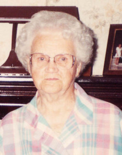
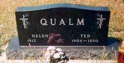
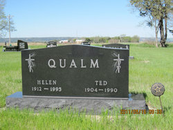
Helen Mae Rasmussen Qualm
| Birth | : | 7 Sep 1912 Bovee, Charles Mix County, South Dakota, USA |
| Death | : | 7 Jul 1995 Platte, Charles Mix County, South Dakota, USA |
| Burial | : | East Bangor Cemetery, East Bangor, Northampton County, USA |
| Coordinate | : | 40.8793200, -75.1778300 |
| Description | : | Helen was a school teacher for 14 years. |
frequently asked questions (FAQ):
-
Where is Helen Mae Rasmussen Qualm's memorial?
Helen Mae Rasmussen Qualm's memorial is located at: East Bangor Cemetery, East Bangor, Northampton County, USA.
-
When did Helen Mae Rasmussen Qualm death?
Helen Mae Rasmussen Qualm death on 7 Jul 1995 in Platte, Charles Mix County, South Dakota, USA
-
Where are the coordinates of the Helen Mae Rasmussen Qualm's memorial?
Latitude: 40.8793200
Longitude: -75.1778300
Family Members:
Parent
Spouse
Siblings
Children
Flowers:
Nearby Cemetories:
1. East Bangor Cemetery
East Bangor, Northampton County, USA
Coordinate: 40.8793200, -75.1778300
2. Gethsemane Ministries Church Cemetery
Bangor, Northampton County, USA
Coordinate: 40.8655200, -75.2038200
3. Stier's Cemetery
Stier, Northampton County, USA
Coordinate: 40.8985920, -75.1529650
4. Johnsonville Cemetery
Johnsonville, Northampton County, USA
Coordinate: 40.9008000, -75.1555400
5. Our Lady of Mount Carmel Catholic Cemetery
Roseto, Northampton County, USA
Coordinate: 40.8751000, -75.2138000
6. Lutheran Cemetery
Bangor, Northampton County, USA
Coordinate: 40.8653000, -75.2103000
7. Saint Johns Cemetery
Bangor, Northampton County, USA
Coordinate: 40.8642006, -75.2114029
8. Roseto Presbyterian Cemetery
Roseto, Northampton County, USA
Coordinate: 40.8803600, -75.2186630
9. New Catholic Cemetery
Roseto, Northampton County, USA
Coordinate: 40.8831200, -75.2214300
10. North Bangor Cemetery
Upper Mount Bethel Township, Northampton County, USA
Coordinate: 40.9011000, -75.2121000
11. Miller Cemetery
Northampton County, USA
Coordinate: 40.8418999, -75.1718979
12. Old Union Cemetery
Stone Church, Northampton County, USA
Coordinate: 40.8656150, -75.1290120
13. Saint Pauls Cemetery
Stone Church, Northampton County, USA
Coordinate: 40.8643900, -75.1284120
14. Reformed Cemetery
Stone Church, Northampton County, USA
Coordinate: 40.8593200, -75.1313900
15. Flicksville Cemetery
Flicksville, Northampton County, USA
Coordinate: 40.8418200, -75.1999900
16. Richmond Methodist Church Cemetery
Richmond, Northampton County, USA
Coordinate: 40.8477000, -75.1419000
17. Saint Josephs Cemetery
West Bangor, Northampton County, USA
Coordinate: 40.8785450, -75.2410080
18. Saint Roch's Parish Church Cemetery
West Bangor, Northampton County, USA
Coordinate: 40.8785720, -75.2417030
19. Old Beck Cemetery
Mount Bethel, Northampton County, USA
Coordinate: 40.8965000, -75.1177000
20. Centreville Cemetery
Upper Mount Bethel Township, Northampton County, USA
Coordinate: 40.8811790, -75.1122551
21. Fairview Cemetery
Pen Argyl, Northampton County, USA
Coordinate: 40.8614006, -75.2397003
22. Saint Elizabeths Cemetery
Pen Argyl, Northampton County, USA
Coordinate: 40.8686000, -75.2433000
23. Mount Bethel Presbyterian Cemetery
Mount Bethel, Northampton County, USA
Coordinate: 40.8999230, -75.1159790
24. Ackermanville United Methodist Church Cemetery
Ackermanville, Northampton County, USA
Coordinate: 40.8363000, -75.2178300


