
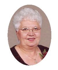
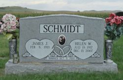
Helen Wald Schmidt
| Birth | : | 19 Jul 1937 Logan County, North Dakota, USA |
| Death | : | 13 Dec 2007 Hazelton, Emmons County, North Dakota, USA |
| Burial | : | Ceres Memorial Park, Ceres, Stanislaus County, USA |
| Coordinate | : | 37.5958214, -120.9634399 |
| Description | : | Helen Schmidt, 70, Hazelton, ND, died December 13, 2007 at her home surrounded by her family. Helen was born on July 19, 1937 in rural Logan County the daughter of Conrad and Margaret (Schmidt) Wald. She was raised and attended school in Logan County. On October 5, 1955, she married James J. Schmidt at St. Michael's Catholic Church. For one year they farmed north of Napoleon, then moved and purchased his father's farm south of Kintyre. She was a parishioner of St. Michael's Catholic Church of rural Linton. She was a member of Altar... Read More |
frequently asked questions (FAQ):
-
Where is Helen Wald Schmidt's memorial?
Helen Wald Schmidt's memorial is located at: Ceres Memorial Park, Ceres, Stanislaus County, USA.
-
When did Helen Wald Schmidt death?
Helen Wald Schmidt death on 13 Dec 2007 in Hazelton, Emmons County, North Dakota, USA
-
Where are the coordinates of the Helen Wald Schmidt's memorial?
Latitude: 37.5958214
Longitude: -120.9634399
Family Members:
Parent

Siblings
Flowers:


Nearby Cemetories:
1. Ceres Memorial Park
Ceres, Stanislaus County, USA
Coordinate: 37.5958214, -120.9634399
2. Saint Stanislaus Catholic Cemetery
Modesto, Stanislaus County, USA
Coordinate: 37.6473610, -120.9808440
3. Modesto Pioneer Cemetery
Modesto, Stanislaus County, USA
Coordinate: 37.6473350, -120.9829040
4. Modesto Citizens Cemetery
Modesto, Stanislaus County, USA
Coordinate: 37.6472930, -120.9845570
5. Acacia Memorial Park
Modesto, Stanislaus County, USA
Coordinate: 37.6481080, -120.9836610
6. Modesto County Cemetery
Modesto, Stanislaus County, USA
Coordinate: 37.6492400, -120.9813800
7. Lakewood Memorial Park
Hughson, Stanislaus County, USA
Coordinate: 37.6199760, -120.8975983
8. Good Shepherd Catholic Cemetery
Modesto, Stanislaus County, USA
Coordinate: 37.6853130, -121.0672890
9. Wood Colony Cemetery
Salida, Stanislaus County, USA
Coordinate: 37.6893730, -121.0682144
10. Turlock Memorial Park
Turlock, Stanislaus County, USA
Coordinate: 37.4937592, -120.8659821
11. Denair Cemetery
Denair, Stanislaus County, USA
Coordinate: 37.5293999, -120.8199997
12. Saint Francis Episcopal Church Columbarium
Turlock, Stanislaus County, USA
Coordinate: 37.5014300, -120.8368400
13. Burwood Cemetery
Escalon, San Joaquin County, USA
Coordinate: 37.7616997, -120.9593964
14. Langworth Cemetery
Oakdale, Stanislaus County, USA
Coordinate: 37.7580986, -120.8957977
15. Grayson Cemetery
Grayson, Stanislaus County, USA
Coordinate: 37.5594559, -121.1802826
16. Martin Cemetery
Waterford, Stanislaus County, USA
Coordinate: 37.6684360, -120.7582160
17. Patterson District Cemetery
Patterson, Stanislaus County, USA
Coordinate: 37.5268135, -121.1728287
18. North Hilmar Cemetery
Hilmar, Merced County, USA
Coordinate: 37.4146614, -120.8864288
19. Oakdale Citizens Cemetery
Oakdale, Stanislaus County, USA
Coordinate: 37.7624600, -120.8388800
20. Ripon Cemetery
Ripon, San Joaquin County, USA
Coordinate: 37.7420311, -121.1238708
21. Oaklawn Memorial Park
Oakdale, Stanislaus County, USA
Coordinate: 37.7711945, -120.8486862
22. Saint John's Catholic Cemetery
Escalon, San Joaquin County, USA
Coordinate: 37.7994537, -121.0705185
23. South Hilmar Cemetery
Hilmar, Merced County, USA
Coordinate: 37.3802681, -120.8868408
24. Valley Home Memorial Park
Oakdale, Stanislaus County, USA
Coordinate: 37.8275528, -120.9333267