
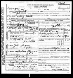

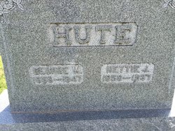
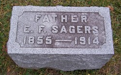
Henrietta Josephine “Nettie” Sagers Hute
| Birth | : | 14 Nov 1858 Ironhills, Jackson County, Iowa, USA |
| Death | : | 9 Feb 1937 Maquoketa, Jackson County, Iowa, USA |
| Burial | : | East Iron Hill Cemetery, Farmers Creek Township, Jackson County, USA |
| Coordinate | : | 42.1465797, -90.7591019 |
| Description | : | Mrs Nettie Hute Of Maquoketa Dies At the Age of 78 MAQUOKETA, la., Feb. 10. (Special) Mrs Nettie J. Hute, 78, wife of George Hute, died at her home here Tuesday night, following an illness of several weeks. Funeral services will be held Friday at 1 p. m. in the family home in Maquoketa and at 2 p. m. in the East Iron Hill church. The Rev. G. F. Barsalou will officiate, and burial will be in East Iron Hill cemetery. She was born Nov. 14, 1858 and married John Sloan Feb. 1, 1877. On Sept. 10, 1882 she married... Read More |
frequently asked questions (FAQ):
-
Where is Henrietta Josephine “Nettie” Sagers Hute's memorial?
Henrietta Josephine “Nettie” Sagers Hute's memorial is located at: East Iron Hill Cemetery, Farmers Creek Township, Jackson County, USA.
-
When did Henrietta Josephine “Nettie” Sagers Hute death?
Henrietta Josephine “Nettie” Sagers Hute death on 9 Feb 1937 in Maquoketa, Jackson County, Iowa, USA
-
Where are the coordinates of the Henrietta Josephine “Nettie” Sagers Hute's memorial?
Latitude: 42.1465797
Longitude: -90.7591019
Family Members:
Parent
Spouse
Siblings
Children

Flowers:


Nearby Cemetories:
1. East Iron Hill Cemetery
Farmers Creek Township, Jackson County, USA
Coordinate: 42.1465797, -90.7591019
2. West Iron Hill Cemetery
Jackson County, USA
Coordinate: 42.1460000, -90.7686000
3. Willison Cemetery
Jackson County, USA
Coordinate: 42.1646000, -90.7783000
4. Streets Cemetery
Ironhills, Jackson County, USA
Coordinate: 42.1796989, -90.7692032
5. Esgate Cemetery
Maquoketa, Jackson County, USA
Coordinate: 42.1292000, -90.7142029
6. Sutton Cemetery
Fulton, Jackson County, USA
Coordinate: 42.1677000, -90.7143000
7. Crabb Cemetery
Crab Town, Jackson County, USA
Coordinate: 42.1749992, -90.8022003
8. Tracy Cemetery
Jackson County, USA
Coordinate: 42.1805992, -90.8067017
9. Said Cemetery
Fulton, Jackson County, USA
Coordinate: 42.1980000, -90.7578000
10. Tilton Cemetery
Jackson County, USA
Coordinate: 42.1236000, -90.6798000
11. Hickory Grove Cemetery
Emeline, Jackson County, USA
Coordinate: 42.1719017, -90.8600006
12. Reel Cemetery
Baldwin, Jackson County, USA
Coordinate: 42.1049995, -90.8510971
13. Pence Cemetery
Baldwin, Jackson County, USA
Coordinate: 42.0746994, -90.8106003
14. Sweezy Cemetery
Otter Creek, Jackson County, USA
Coordinate: 42.2005997, -90.6699982
15. Buckhorn Waterford Cemetery
Buckhorn, Jackson County, USA
Coordinate: 42.0607986, -90.7517014
16. Saint Aloysius Cemetery
South Garry Owen, Jackson County, USA
Coordinate: 42.2257996, -90.8052979
17. Hershberger Cemetery
Baldwin, Jackson County, USA
Coordinate: 42.0772309, -90.8418011
18. Holy Trinity Catholic Cemetery
Baldwin, Jackson County, USA
Coordinate: 42.0770000, -90.8420000
19. Ozark Cemetery
Ozark, Jackson County, USA
Coordinate: 42.2005000, -90.8735000
20. Saint Lawrence Cemetery
Zwingle, Jackson County, USA
Coordinate: 42.2412000, -90.6956000
21. Canton Cemetery
Canton, Jones County, USA
Coordinate: 42.1647072, -90.9020386
22. Goddard Cemetery
Maquoketa, Jackson County, USA
Coordinate: 42.0391998, -90.7335968
23. Mount Hope Cemetery
Maquoketa, Jackson County, USA
Coordinate: 42.0615616, -90.6619720
24. Bridgeport Cemetery
Maquoketa, Jackson County, USA
Coordinate: 42.0906000, -90.6267000