

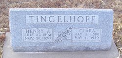
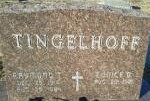
Henry Aloys Tingelhoff
| Birth | : | 27 Jul 1892 West Point, Cuming County, Nebraska, USA |
| Death | : | 28 Nov 1970 Lexington, Dawson County, Nebraska, USA |
| Burial | : | Saint Anns Cemetery, Lexington, Dawson County, USA |
| Coordinate | : | 40.7789001, -99.7114029 |
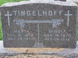
| Description | : | Henry A. Tingelhoff, 78, retired farmer, formerly of West Point died Sat. Nov. 28, 1970 at his home.Funeral mass for Mr. Tingelhoff was Monday, Nov. 30, in St. Ann's Catholic Church and the Rev. Robert Warner officiated. Interment was in St. Ann's cemetery and the following were pallbearers; Fred Racek, Don Parsch, Lewis Straka, Clarence Larson, Eugene Conney and Joe Harding. The Tingelhoffs moved to Lexington from West Point in 1927 and farmed near there until 1961 when they retired and moved to Lexington. Henry A. Tingelhoff, son of Minolph and Mary (Wortman) Tingelhoff was born July 27, 1892 at... Read More |
frequently asked questions (FAQ):
-
Where is Henry Aloys Tingelhoff's memorial?
Henry Aloys Tingelhoff's memorial is located at: Saint Anns Cemetery, Lexington, Dawson County, USA.
-
When did Henry Aloys Tingelhoff death?
Henry Aloys Tingelhoff death on 28 Nov 1970 in Lexington, Dawson County, Nebraska, USA
-
Where are the coordinates of the Henry Aloys Tingelhoff's memorial?
Latitude: 40.7789001
Longitude: -99.7114029
Family Members:
Parent

Spouse
Siblings

Children

Flowers:


Nearby Cemetories:
1. Greenwood Cemetery
Lexington, Dawson County, USA
Coordinate: 40.7956467, -99.7286682
2. First United Methodist Church Columbarium
Lexington, Dawson County, USA
Coordinate: 40.7810000, -99.7397000
3. Evergreen Cemetery
Lexington, Dawson County, USA
Coordinate: 40.7639008, -99.6791992
4. Mount Hope Cemetery
Dawson County, USA
Coordinate: 40.8293991, -99.6733017
5. Hewitt Cemetery
Lexington, Dawson County, USA
Coordinate: 40.8588982, -99.7769012
6. Robb Cemetery
Smithfield, Gosper County, USA
Coordinate: 40.6710691, -99.6996001
7. Buffalo Grove Presbyterian Church Cemetery
Buffalo, Dawson County, USA
Coordinate: 40.8721000, -99.8270000
8. Hillside Cemetery
Dawson County, USA
Coordinate: 40.8946991, -99.7869034
9. Plum Creek Massacre Cemetery
Phelps County, USA
Coordinate: 40.6726840, -99.6058220
10. Grace Cemetery
Cozad, Dawson County, USA
Coordinate: 40.8602982, -99.8644028
11. Overton Cemetery
Overton, Dawson County, USA
Coordinate: 40.7317009, -99.5222015
12. Saint Johns Lutheran Cemetery
Lexington, Dawson County, USA
Coordinate: 40.9019012, -99.8458023
13. Quakerville Cemetery
Gosper County, USA
Coordinate: 40.6189003, -99.8097000
14. Adullam Cemetery
Bertrand, Phelps County, USA
Coordinate: 40.6265000, -99.5856000
15. Cozad Cemetery
Cozad, Dawson County, USA
Coordinate: 40.8605995, -99.9475021
16. Elwood Cemetery
Elwood, Gosper County, USA
Coordinate: 40.5999300, -99.8397300
17. Platte Valley Cemetery
Phelps County, USA
Coordinate: 40.6425018, -99.5028000
18. Keely Cemetery
Smithfield, Gosper County, USA
Coordinate: 40.5727500, -99.6563500
19. Saint Patricks Cemetery
Eddyville, Dawson County, USA
Coordinate: 40.9747009, -99.6093979
20. Sandstrom Cemetery
Phelps County, USA
Coordinate: 40.5983009, -99.5661011
21. Jewell Cemetery
Sumner, Dawson County, USA
Coordinate: 40.9599991, -99.5646973
22. Hope Lutheran Cemetery
Smithfield, Gosper County, USA
Coordinate: 40.5667500, -99.6800000
23. Fairview Cemetery
Dawson County, USA
Coordinate: 40.7719002, -99.9955978
24. Cottonwood Cemetery
Dawson County, USA
Coordinate: 40.9322014, -99.9197006