
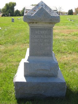

Henry Claus Schoenjahn
| Birth | : | 12 Jun 1847 Germany |
| Death | : | 24 Apr 1915 Crawford County, Iowa, USA |
| Burial | : | Westside Cemetery, Westside, Crawford County, USA |
| Coordinate | : | 42.0602989, -95.0922012 |
| Plot | : | Block D Lot 85 Plot 3 |
| Description | : | Henry Claus Schoenjahn (son of A. G. Schoenjahn and Anna Stolberry) was born 12 Jun 1847 in Aschberg Hoffnear Plan, Germany, and died 24 Apr 1915 in Westside IA. He married Paulina Gradert on Jan 1873 in Bryant IA, daughter of John Gradert and Juliane Hoeft. Henry Claus Schoenjahn worked as a carpenter on a bridge gang as the main line of the Chicago & Northwestern R.R. was being laid from Chicago to Omaha. While working in the vicinity of Westside, he was pleased with the farmland of the area and purchased 120 acres. He then brought his wife from Clinton... Read More |
frequently asked questions (FAQ):
-
Where is Henry Claus Schoenjahn's memorial?
Henry Claus Schoenjahn's memorial is located at: Westside Cemetery, Westside, Crawford County, USA.
-
When did Henry Claus Schoenjahn death?
Henry Claus Schoenjahn death on 24 Apr 1915 in Crawford County, Iowa, USA
-
Where are the coordinates of the Henry Claus Schoenjahn's memorial?
Latitude: 42.0602989
Longitude: -95.0922012
Family Members:
Spouse
Children

Flowers:


Nearby Cemetories:
1. Westside Cemetery
Westside, Crawford County, USA
Coordinate: 42.0602989, -95.0922012
2. Saint Johns Catholic Cemetery
Arcadia, Carroll County, USA
Coordinate: 42.0855406, -95.0341577
3. Hayes Township Cemetery
Westside, Crawford County, USA
Coordinate: 42.0083199, -95.1216583
4. Saint Anns Cemetery
Vail, Crawford County, USA
Coordinate: 42.0513992, -95.1868973
5. Arcadia Cemetery
Arcadia Township, Carroll County, USA
Coordinate: 42.1000680, -95.0130550
6. Vail Cemetery
Vail, Crawford County, USA
Coordinate: 42.0647011, -95.2102966
7. Saint Augustine Cemetery
Halbur, Carroll County, USA
Coordinate: 42.0066986, -94.9744034
8. King Cemetery
Vail, Crawford County, USA
Coordinate: 42.1007996, -95.2319031
9. Saint Francis Cemetery
Maple River, Carroll County, USA
Coordinate: 42.0969009, -94.9372025
10. Wheatland Cemetery
Carroll County, USA
Coordinate: 42.1814003, -95.0582962
11. Iowa Township Cemetery
Aspinwall, Crawford County, USA
Coordinate: 41.9216995, -95.1113968
12. Holy Angels Cemetery
Carroll County, USA
Coordinate: 42.0014000, -94.9141998
13. Saint Bernards Cemetery
Breda, Carroll County, USA
Coordinate: 42.1786003, -94.9732971
14. Sacred Heart Cemetery
Manning, Carroll County, USA
Coordinate: 41.9132500, -95.0540000
15. Manning Cemetery
Manning, Carroll County, USA
Coordinate: 41.8990000, -95.0620000
16. Our Lady Of Mount Carmel Cemetery
Mount Carmel, Carroll County, USA
Coordinate: 42.1547012, -94.9088974
17. Deloit Cemetery
Deloit, Crawford County, USA
Coordinate: 42.1075325, -95.3136520
18. South Wall Lake Cemetery
Wall Lake, Sac County, USA
Coordinate: 42.2318993, -95.0911026
19. Carroll City Cemetery
Carroll, Carroll County, USA
Coordinate: 42.0560963, -94.8599856
20. Mount Olivet Cemetery
Carroll, Carroll County, USA
Coordinate: 42.0536340, -94.8595510
21. Saint John Lutheran Church Cemetery
Crawford County, USA
Coordinate: 42.1780000, -95.2650000
22. Old Catholic Cemetery
Denison, Crawford County, USA
Coordinate: 42.0043983, -95.3189011
23. Sacred Heart Cemetery
Templeton, Carroll County, USA
Coordinate: 41.9138746, -94.9460994
24. Immanuel Presbyterian Cemetery
Carnarvon, Sac County, USA
Coordinate: 42.2392006, -95.0224991