Henry Clay Baker
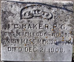
| Birth | : | 30 Mar 1830 Franklin County, Massachusetts, USA |
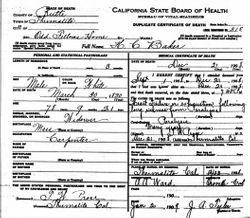
| Death | : | 21 Dec 1908 Thermalito, Butte County, California, USA |
| Burial | : | Tate Township Cemetery, Bethel, Clermont County, USA |
| Coordinate | : | 38.9592018, -84.0742035 |
| Inscription | : | b. Mass |
frequently asked questions (FAQ):
-
Where is Henry Clay Baker's memorial?
Henry Clay Baker's memorial is located at: Tate Township Cemetery, Bethel, Clermont County, USA.
-
When did Henry Clay Baker death?
Henry Clay Baker death on 21 Dec 1908 in Thermalito, Butte County, California, USA
-
Where are the coordinates of the Henry Clay Baker's memorial?
Latitude: 38.9592018
Longitude: -84.0742035
Family Members:
Parent
Siblings
Flowers:
Nearby Cemetories:
1. Tate Township Cemetery
Bethel, Clermont County, USA
Coordinate: 38.9592018, -84.0742035
2. Early Settlers Burying Ground
Bethel, Clermont County, USA
Coordinate: 38.9591600, -84.0741600
3. Bredwell Cemetery
Tate Township, Clermont County, USA
Coordinate: 38.9356300, -84.0776600
4. Hunt Cemetery
Bethel, Clermont County, USA
Coordinate: 38.9400830, -84.0558330
5. Brown Family Cemetery
Bethel, Clermont County, USA
Coordinate: 38.9838390, -84.0811730
6. Reed Cemetery
Bethel, Clermont County, USA
Coordinate: 38.9889330, -84.0799330
7. Swing Family Cemetery
Bethel, Clermont County, USA
Coordinate: 38.9750220, -84.1083140
8. Clover Cemetery
Williamsburg, Clermont County, USA
Coordinate: 38.9986800, -84.0416700
9. Sugartree Cemetery
Tate Township, Clermont County, USA
Coordinate: 38.9682999, -84.1343994
10. Moyer Cemetery
Pike Township, Brown County, USA
Coordinate: 38.9876670, -84.0249760
11. Brooks Family Cemetery
Hamersville, Brown County, USA
Coordinate: 38.9710999, -84.0010986
12. Earhart Cemetery
Locust Ridge, Brown County, USA
Coordinate: 38.9899700, -84.0057560
13. Wells Family Cemetery
Bethel, Clermont County, USA
Coordinate: 38.8976170, -84.0776170
14. Frazee Farm Cemetery
Saltair, Clermont County, USA
Coordinate: 38.9330000, -84.1491920
15. Concord Church Cemetery
Concord, Clermont County, USA
Coordinate: 39.0235600, -84.0743500
16. Neal Cemetery
Clark Township, Brown County, USA
Coordinate: 38.9614280, -83.9860690
17. Old Bethel M.E. Churchyard
Bethel, Clermont County, USA
Coordinate: 39.0076700, -84.1390100
18. Monroe Presbyterian Cemetery
Nicholsville, Clermont County, USA
Coordinate: 38.9682999, -84.1635971
19. Hamersville Cemetery
Hamersville, Brown County, USA
Coordinate: 38.9275017, -83.9927979
20. Nicholsville Cemetery
Nicholsville, Clermont County, USA
Coordinate: 38.9575539, -84.1699753
21. New Harmony Cemetery
New Harmony, Brown County, USA
Coordinate: 39.0149994, -84.0081024
22. Point Isabel Cemetery
Moscow, Clermont County, USA
Coordinate: 38.8985300, -84.1340200
23. Altman-Swope Cemetery
Wiggonsville, Clermont County, USA
Coordinate: 38.8871540, -84.1248330
24. Armacost Cemetery
Point Isabel, Clermont County, USA
Coordinate: 38.9022580, -84.1566810


