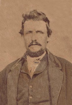
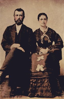
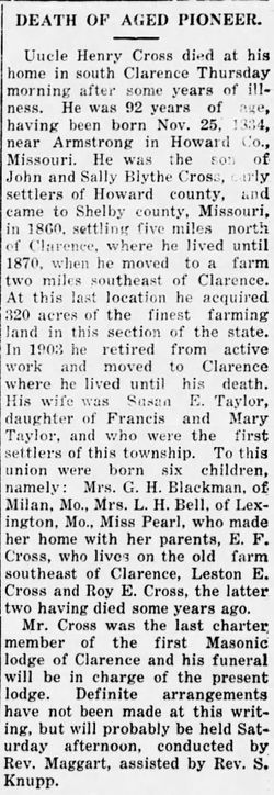
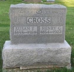
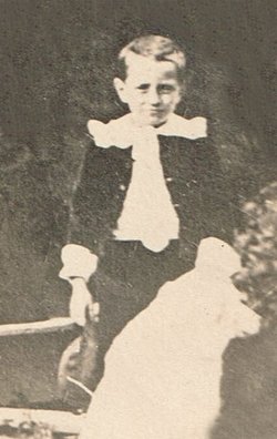
Henry Clay Cross
| Birth | : | 25 Nov 1834 Roanoke, Howard County, Missouri, USA |
| Death | : | 6 Jan 1927 Clarence, Shelby County, Missouri, USA |
| Burial | : | Washington Township Cemetery, Duncombe, Webster County, USA |
| Coordinate | : | 42.4707900, -94.0002000 |
| Plot | : | AOUW Block 1 Row 8 Lot 68n |
| Description | : | Henry Clay Cross was representative of the pioneer families who settled Missouri. He moved to Shelby County in about 1860. He was the son of John Cross and Sallie Blythe Cross. They moved to Howard County, MO in 1818 from Kentucky. Mr. Cross was a farmer and had over 320 acres, including over 500 fruit trees of various kinds. He was a large producer of stock and farm products. He was a well known and well respected citizen. (Courtesy of The History of Monroe and Shelby Counties, National Historical Co., 1884). |
frequently asked questions (FAQ):
-
Where is Henry Clay Cross's memorial?
Henry Clay Cross's memorial is located at: Washington Township Cemetery, Duncombe, Webster County, USA.
-
When did Henry Clay Cross death?
Henry Clay Cross death on 6 Jan 1927 in Clarence, Shelby County, Missouri, USA
-
Where are the coordinates of the Henry Clay Cross's memorial?
Latitude: 42.4707900
Longitude: -94.0002000
Family Members:
Parent
Spouse
Siblings
Children
Nearby Cemetories:
1. Washington Township Cemetery
Duncombe, Webster County, USA
Coordinate: 42.4707900, -94.0002000
2. Saint Josephs Cemetery
Duncombe, Webster County, USA
Coordinate: 42.4789009, -93.9922028
3. Washington Cemetery
Duncombe, Webster County, USA
Coordinate: 42.4277992, -93.9916992
4. Colfax Cemetery
Webster County, USA
Coordinate: 42.5224991, -94.0194016
5. Blanchard Cemetery
Webster County, USA
Coordinate: 42.4021988, -93.9997025
6. Holaday Creek Cemetery
Webster County, USA
Coordinate: 42.4472008, -94.0886002
7. Border Plains Cemetery
Border Plains, Webster County, USA
Coordinate: 42.3917000, -94.0448000
8. Ober and Scott Cemetery
Duncombe, Webster County, USA
Coordinate: 42.3841390, -93.9982856
9. Hartman Cemetery
Lehigh, Webster County, USA
Coordinate: 42.3666397, -93.9835627
10. Otho Cemetery
Otho, Webster County, USA
Coordinate: 42.4025002, -94.1153030
11. Fort Dodge Memorial Park
Fort Dodge, Webster County, USA
Coordinate: 42.5032997, -94.1472015
12. West Lawn Cemetery
Lehigh, Webster County, USA
Coordinate: 42.3616982, -94.0678024
13. Homer Cemetery
Homer, Hamilton County, USA
Coordinate: 42.3680992, -93.9088974
14. Community Church Cemetery
Kamrar, Hamilton County, USA
Coordinate: 42.4556000, -93.8342000
15. Calvary Cemetery
Webster City, Hamilton County, USA
Coordinate: 42.4556007, -93.8341980
16. Graceland Cemetery
Webster City, Hamilton County, USA
Coordinate: 42.4578018, -93.8308029
17. Teters Family Cemetery
Vincent, Webster County, USA
Coordinate: 42.6005700, -94.0034200
18. McGuire Bend Cemetery
Dayton, Webster County, USA
Coordinate: 42.3410000, -93.9880000
19. Oak Grove Cemetery
Lehigh, Webster County, USA
Coordinate: 42.3438988, -94.0475006
20. Newark Township Cemetery
Vincent, Webster County, USA
Coordinate: 42.6021996, -94.0408020
21. Trails End Cemetery
Webster City, Hamilton County, USA
Coordinate: 42.4587810, -93.8128710
22. Oakland Cemetery
Fort Dodge, Webster County, USA
Coordinate: 42.5214005, -94.1800003
23. Corpus Christi Cemetery
Fort Dodge, Webster County, USA
Coordinate: 42.5243988, -94.1802979
24. North Lawn Cemetery
Fort Dodge, Webster County, USA
Coordinate: 42.5290000, -94.1778000

