Henry Corbin Flanders
| Birth | : | 7 Jul 1921 |
| Death | : | 26 May 2008 |
| Burial | : | Collinsville Cemetery, Collinsville, Whitsunday Region, Australia |
| Coordinate | : | -20.5690210, 147.8369070 |
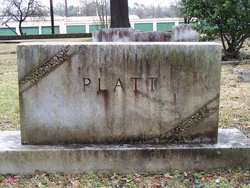
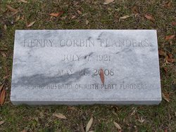
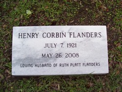
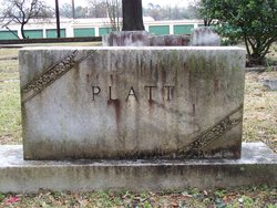
| Inscription | : | Platt Henry Corbin Flanders July 7 1921 May 6 2008 Loving husband of Ruth Platt Flanders |
| Description | : | Georgetown: Henry Corbin Flanders, 86, died Monday, May 26, 2008 at his residence. Mr. Flanders was born in Swainsboro, Ga. on July 7, 1921, a son of the late Willie M. Flanders and Georgie Smith Flanders. He grew up in Swainsboro and graduated from high school there. Mr. Flanders served in the Army Air Corps during World War II. He lived in Charleston prior to moving to Georgetown. Mr. Flanders retired as the manager of the Colonial Stores, Inc. grocery store in Georgetown. He was a member of Duncan Memorial United Methodist Church and was a former member of the church Board... Read More |
frequently asked questions (FAQ):
-
Where is Henry Corbin Flanders's memorial?
Henry Corbin Flanders's memorial is located at: Collinsville Cemetery, Collinsville, Whitsunday Region, Australia.
-
When did Henry Corbin Flanders death?
Henry Corbin Flanders death on 26 May 2008 in
-
Where are the coordinates of the Henry Corbin Flanders's memorial?
Latitude: -20.5690210
Longitude: 147.8369070
Family Members:
Spouse
Flowers:
Nearby Cemetories:
1. Collinsville Cemetery
Collinsville, Whitsunday Region, Australia
Coordinate: -20.5690210, 147.8369070
2. Cunningham Family Cemetery
Collinsville, Whitsunday Region, Australia
Coordinate: -20.4982000, 147.6299000
3. Bowen Flemington Road Cemetery
Bowen, Whitsunday Region, Australia
Coordinate: -20.0059100, 148.2123100
4. Stone Island Homestead Cemetery
Bowen, Whitsunday Region, Australia
Coordinate: -20.0361500, 148.2790300
5. Bowen General Cemetery
Bowen, Whitsunday Region, Australia
Coordinate: -20.0014860, 148.2321260
6. Proserpine General Cemetery
Proserpine, Whitsunday Region, Australia
Coordinate: -20.3953000, 148.5638000
7. Proserpine Lawn Cemetery
Proserpine, Whitsunday Region, Australia
Coordinate: -20.3929770, 148.5636941
8. St Paul's Anglican Church Columbarium Wall
Proserpine, Whitsunday Region, Australia
Coordinate: -20.4016710, 148.5800580
9. Mount Coolon Cemetery
Mount Coolon, Whitsunday Region, Australia
Coordinate: -21.3870730, 147.3336270
10. Finch Hatton Cemetery
Finch Hatton, Mackay Region, Australia
Coordinate: -21.1417670, 148.6587180
11. Home Hill General Cemetery
Home Hill, Burdekin Shire, Australia
Coordinate: -19.6630800, 147.4259200
12. St Helens Anglican Church Columbarium Wall
Home Hill, Burdekin Shire, Australia
Coordinate: -19.6572720, 147.4130880
13. Ravenswood Cemetery
Ravenswood, Charters Towers Region, Australia
Coordinate: -20.1116040, 146.8872210
14. Pinnacle Cemetery
Pinnacle, Mackay Region, Australia
Coordinate: -21.1474530, 148.7124820
15. Mount Britton Cemetery
Nebo, Isaac Region, Australia
Coordinate: -21.4041410, 148.5417400
16. Ayr Cemetery
Ayr, Burdekin Shire, Australia
Coordinate: -19.5641000, 147.3909940
17. Jolimont Cemetery
Kuttabul, Mackay Region, Australia
Coordinate: -21.0330800, 148.9045300
18. Mirani Cemetery
Mirani, Mackay Region, Australia
Coordinate: -21.1610090, 148.8515450
19. Hampden Cemetery
Hampden, Mackay Region, Australia
Coordinate: -21.0619800, 148.9343390
20. Double Peaks Cemetery
Mackay Region, Australia
Coordinate: -21.1994530, 148.8914720
21. Marian Cemetery
Marian, Mackay Region, Australia
Coordinate: -21.1469138, 148.9642882
22. Mandarana Cemetery
Mackay, Mackay Region, Australia
Coordinate: -21.0906510, 149.0389450
23. Giru-Woodstock Road Homestead Cemetery
Giru, Burdekin Shire, Australia
Coordinate: -19.5477500, 147.0598300
24. Walkerston Cemetery
Walkerston, Mackay Region, Australia
Coordinate: -21.1613710, 149.0785820


