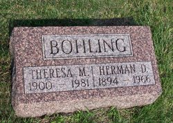
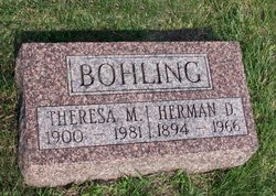
Herman Dietrich Bohling
| Birth | : | 14 Aug 1894 Auburn, Nemaha County, Nebraska, USA |
| Death | : | 29 Mar 1966 Auburn, Nemaha County, Nebraska, USA |
| Burial | : | Mica Creek Cemetery, Rockford, Spokane County, USA |
| Coordinate | : | 47.5217018, -117.1093979 |
| Description | : | Son of Wilhelm Bohling and Maria Ottens, he was born on a farm in the Hickory Grove community near Auburn, NE. He was one of 6 children. He was baptized on September 11, 1894, at St. Paul Hickory Grove Lutheran Church, in rural Auburn, Nebr. and confirmed in the same church on April 26, 1908. In his later years he transferred his membership to St. Paul's Lutheran Church in Auburn, NE. and was a member for over 40 years. Herman was married on Feb. 14, 1917, at St. Matthews Lutheran Church, in Johnson, Nebr.... Read More |
frequently asked questions (FAQ):
-
Where is Herman Dietrich Bohling's memorial?
Herman Dietrich Bohling's memorial is located at: Mica Creek Cemetery, Rockford, Spokane County, USA.
-
When did Herman Dietrich Bohling death?
Herman Dietrich Bohling death on 29 Mar 1966 in Auburn, Nemaha County, Nebraska, USA
-
Where are the coordinates of the Herman Dietrich Bohling's memorial?
Latitude: 47.5217018
Longitude: -117.1093979
Family Members:
Parent
Spouse
Siblings
Children
Flowers:
Nearby Cemetories:
1. Mica Creek Cemetery
Rockford, Spokane County, USA
Coordinate: 47.5217018, -117.1093979
2. Mica Peak Cemetery
Saxby, Spokane County, USA
Coordinate: 47.5078011, -117.0764008
3. Evergreen Cemetery
Freeman, Spokane County, USA
Coordinate: 47.5181790, -117.1886620
4. Mica Cemetery
Mica, Spokane County, USA
Coordinate: 47.5433006, -117.2146988
5. Fairview Cemetery
Rockford, Spokane County, USA
Coordinate: 47.4421997, -117.1296997
6. Wood Memorial Cemetery
Valleyford, Spokane County, USA
Coordinate: 47.5071983, -117.2692032
7. Spring Valley Cemetery
Spring Valley, Spokane County, USA
Coordinate: 47.5150140, -117.2713870
8. Saltese Cemetery
Greenacres, Spokane County, USA
Coordinate: 47.6278000, -117.1660995
9. Mount Hope Cemetery
Mount Hope, Spokane County, USA
Coordinate: 47.4477997, -117.2382965
10. Spokane Valley Church of the Nazarene Columbarium
Spokane, Spokane County, USA
Coordinate: 47.6393000, -117.1948000
11. Chester Community Cemetery
Chester, Spokane County, USA
Coordinate: 47.6138802, -117.2486343
12. South Pines Cemetery
Spokane, Spokane County, USA
Coordinate: 47.6277000, -117.2261500
13. Butte Cemetery
Spokane County, USA
Coordinate: 47.3850000, -117.0577780
14. Pines Cemetery
Spokane Valley, Spokane County, USA
Coordinate: 47.6425018, -117.2416992
15. Fairfield Cemetery
Fairfield, Spokane County, USA
Coordinate: 47.3699989, -117.1402969
16. Worley Cemetery
Worley, Kootenai County, USA
Coordinate: 47.4199982, -116.9167023
17. Queen of Peace Cemetery
Spokane, Spokane County, USA
Coordinate: 47.5893200, -117.3409370
18. Saint Michaels Cemetery
Worley, Kootenai County, USA
Coordinate: 47.4098000, -116.9111100
19. Saint John Vianney Catholic Church Columbarium
Spokane, Spokane County, USA
Coordinate: 47.6619000, -117.2715000
20. Rosewood Cemetery
Fairfield, Spokane County, USA
Coordinate: 47.3474998, -117.1722031
21. Saint Josephs Cemetery
Trentwood, Spokane County, USA
Coordinate: 47.6996994, -117.1632996
22. Pleasant View Cemetery
Post Falls, Kootenai County, USA
Coordinate: 47.6961000, -117.0111000
23. Woodlawn Cemetery
Spokane, Spokane County, USA
Coordinate: 47.6492004, -117.3135986
24. Moran Cemetery
Spokane, Spokane County, USA
Coordinate: 47.5957985, -117.3685989


