
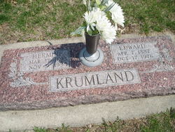
Hermine “Minnie” Brakenhoff Krumland
| Birth | : | 17 Mar 1893 Platte County, Nebraska, USA |
| Death | : | 9 Nov 1995 Columbus, Platte County, Nebraska, USA |
| Burial | : | Dodge Cemetery, Sutton, Worcester County, USA |
| Coordinate | : | 42.1573100, -71.7008100 |
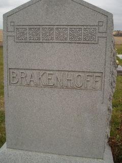
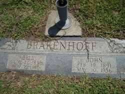
| Description | : | Daughter of Eilert and Rika (Becher) Brakenhoff. Married Edward Krunland on Oct 2, 1916 at St. John's church. per dia |
frequently asked questions (FAQ):
-
Where is Hermine “Minnie” Brakenhoff Krumland's memorial?
Hermine “Minnie” Brakenhoff Krumland's memorial is located at: Dodge Cemetery, Sutton, Worcester County, USA.
-
When did Hermine “Minnie” Brakenhoff Krumland death?
Hermine “Minnie” Brakenhoff Krumland death on 9 Nov 1995 in Columbus, Platte County, Nebraska, USA
-
Where are the coordinates of the Hermine “Minnie” Brakenhoff Krumland's memorial?
Latitude: 42.1573100
Longitude: -71.7008100
Family Members:
Parent

Spouse

Siblings
Children

Flowers:


Nearby Cemetories:
1. Dodge Cemetery
Sutton, Worcester County, USA
Coordinate: 42.1573100, -71.7008100
2. Orchard View Cemetery
Sutton, Worcester County, USA
Coordinate: 42.1613760, -71.7107900
3. Wilkinsonville Cemetery
Sutton, Worcester County, USA
Coordinate: 42.1716450, -71.7225750
4. Saint John's Episcopal Church Burial Site
Sutton, Worcester County, USA
Coordinate: 42.1745870, -71.7196110
5. Old Farnumsville Cemetery
Grafton, Worcester County, USA
Coordinate: 42.1728325, -71.6776581
6. Armsby Cemetery
Sutton, Worcester County, USA
Coordinate: 42.1516991, -71.7319031
7. Fairview Cemetery
Grafton, Worcester County, USA
Coordinate: 42.1666985, -71.6714020
8. Cooper Road Cemetery
Northbridge, Worcester County, USA
Coordinate: 42.1433790, -71.6636470
9. Titus-Lowe Burial Lot
Sutton, Worcester County, USA
Coordinate: 42.1324230, -71.7257150
10. Old Cemetery
Northbridge, Worcester County, USA
Coordinate: 42.1326040, -71.6723420
11. New Howard Cemetery
Sutton, Worcester County, USA
Coordinate: 42.1514620, -71.7475300
12. Old Howard Cemetery
Sutton, Worcester County, USA
Coordinate: 42.1513220, -71.7478470
13. Freegrace Marble Farm Cemetery
Sutton, Worcester County, USA
Coordinate: 42.1637500, -71.7507600
14. Lackey Cemetery
Northbridge, Worcester County, USA
Coordinate: 42.1181690, -71.6917240
15. Riverdale Cemetery
Northbridge, Worcester County, USA
Coordinate: 42.1366300, -71.6469300
16. Benson Cemetery
Northbridge, Worcester County, USA
Coordinate: 42.1359220, -71.6470820
17. Saint Philips Catholic Cemetery
Grafton, Worcester County, USA
Coordinate: 42.2028008, -71.7027969
18. Carpenter Cemetery
Sutton, Worcester County, USA
Coordinate: 42.1425500, -71.7599300
19. Sutton Center Cemetery
Sutton, Worcester County, USA
Coordinate: 42.1492540, -71.7632000
20. Fowler Cemetery
Northbridge, Worcester County, USA
Coordinate: 42.1463320, -71.6390170
21. Riverside Cemetery
Grafton, Worcester County, USA
Coordinate: 42.2057266, -71.6985550
22. Saint Patricks Cemetery
Northbridge, Worcester County, USA
Coordinate: 42.1292000, -71.6457977
23. Cole-Woodbury Cemetery
Sutton, Worcester County, USA
Coordinate: 42.1463310, -71.7676440
24. Millbury Cemetery
Millbury, Worcester County, USA
Coordinate: 42.1914940, -71.7515945