
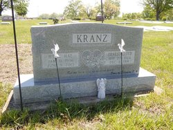
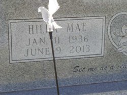
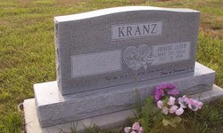
Hilda Mae Mauersberger Kranz
| Birth | : | 11 Jan 1936 Elgin, Comanche County, Oklahoma, USA |
| Death | : | 9 Jun 2013 Holton, Jackson County, Kansas, USA |
| Burial | : | Wetmore Cemetery, Wetmore, Nemaha County, USA |
| Coordinate | : | 39.6396800, -95.8108400 |
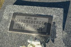
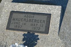
| Description | : | ************************************** Hilda Mae Kranz, 77, of Holton, died Sunday, June 9, 2013 at her home. She was born January 11, 1936 at Elgin, Oklahoma, the daughter of Emil and Addie Shumaker Mauersberger. The family moved to Wetmore, Kansas in 1936 where she attended the Shumaker Country School. She graduated from Wetmore High School in 1953. Hilda worked for the Wetmore Telephone Company. She also worked for Harrah's and later Prairie Band Casino at Mayetta. She was a member of the Larkinburg Christian Church. Hilda married Ernest "Lloyd" Kranz on August 17, 1957 at Holton. He died December 11, 1991. She was... Read More |
frequently asked questions (FAQ):
-
Where is Hilda Mae Mauersberger Kranz's memorial?
Hilda Mae Mauersberger Kranz's memorial is located at: Wetmore Cemetery, Wetmore, Nemaha County, USA.
-
When did Hilda Mae Mauersberger Kranz death?
Hilda Mae Mauersberger Kranz death on 9 Jun 2013 in Holton, Jackson County, Kansas, USA
-
Where are the coordinates of the Hilda Mae Mauersberger Kranz's memorial?
Latitude: 39.6396800
Longitude: -95.8108400
Family Members:
Parent
Spouse
Siblings
Children

Flowers:


Nearby Cemetories:
1. Wetmore Cemetery
Wetmore, Nemaha County, USA
Coordinate: 39.6396800, -95.8108400
2. Wolfley Cemetery
Goff, Nemaha County, USA
Coordinate: 39.6454400, -95.8633900
3. South Powhattan Cemetery
Powhattan, Brown County, USA
Coordinate: 39.6608009, -95.7596970
4. Netawaka Cemetery
Netawaka, Jackson County, USA
Coordinate: 39.6075300, -95.7223700
5. Pleasant Grove Cemetery
Jackson County, USA
Coordinate: 39.5664000, -95.7789000
6. Barnes Cemetery
Goff, Nemaha County, USA
Coordinate: 39.6960983, -95.8824997
7. Granada Cemetery
Granada, Nemaha County, USA
Coordinate: 39.7324982, -95.7988968
8. Ontario Cemetery
Nemaha County, USA
Coordinate: 39.5663795, -95.8885193
9. Fairview Cemetery
Goff, Nemaha County, USA
Coordinate: 39.6831017, -95.9383011
10. Grant-Mjessepe Cemetery
Horton, Brown County, USA
Coordinate: 39.6663000, -95.6576000
11. Comet Cemetery
Powhattan Township, Brown County, USA
Coordinate: 39.7542600, -95.7340400
12. Kennekuk Church Cemetery
Horton, Brown County, USA
Coordinate: 39.7074600, -95.6672300
13. Jessepe Indian Cemetery
Horton, Brown County, USA
Coordinate: 39.6715000, -95.6438000
14. Capioma Cemetery
Capioma, Nemaha County, USA
Coordinate: 39.7805099, -95.8205719
15. Carmel Cemetery
Circleville, Jackson County, USA
Coordinate: 39.4984400, -95.7967700
16. Circleville Cemetery
Circleville, Jackson County, USA
Coordinate: 39.5014000, -95.8664017
17. Pleasant Hill Cemetery
Corning, Nemaha County, USA
Coordinate: 39.6895800, -95.9907400
18. Grasshopper Burial Ground
Powhattan Township, Brown County, USA
Coordinate: 39.7578020, -95.6949820
19. Saint Augustine Catholic Cemetery
Capioma Township, Nemaha County, USA
Coordinate: 39.7904282, -95.7897034
20. Soldier Cemetery
Soldier, Jackson County, USA
Coordinate: 39.5417900, -95.9654800
21. Woodlawn Cemetery
Woodlawn, Nemaha County, USA
Coordinate: 39.7905998, -95.8638992
22. Spring Hill Cemetery
Whiting, Jackson County, USA
Coordinate: 39.6021996, -95.6121979
23. Jonach Cemetery
Nemaha County, USA
Coordinate: 39.7925700, -95.8646600
24. Saint Patricks Cemetery
Corning, Nemaha County, USA
Coordinate: 39.6521988, -96.0250015